Hicks Mountain Topo Map Nevada
To zoom in, hover over the map of Hicks Mountain
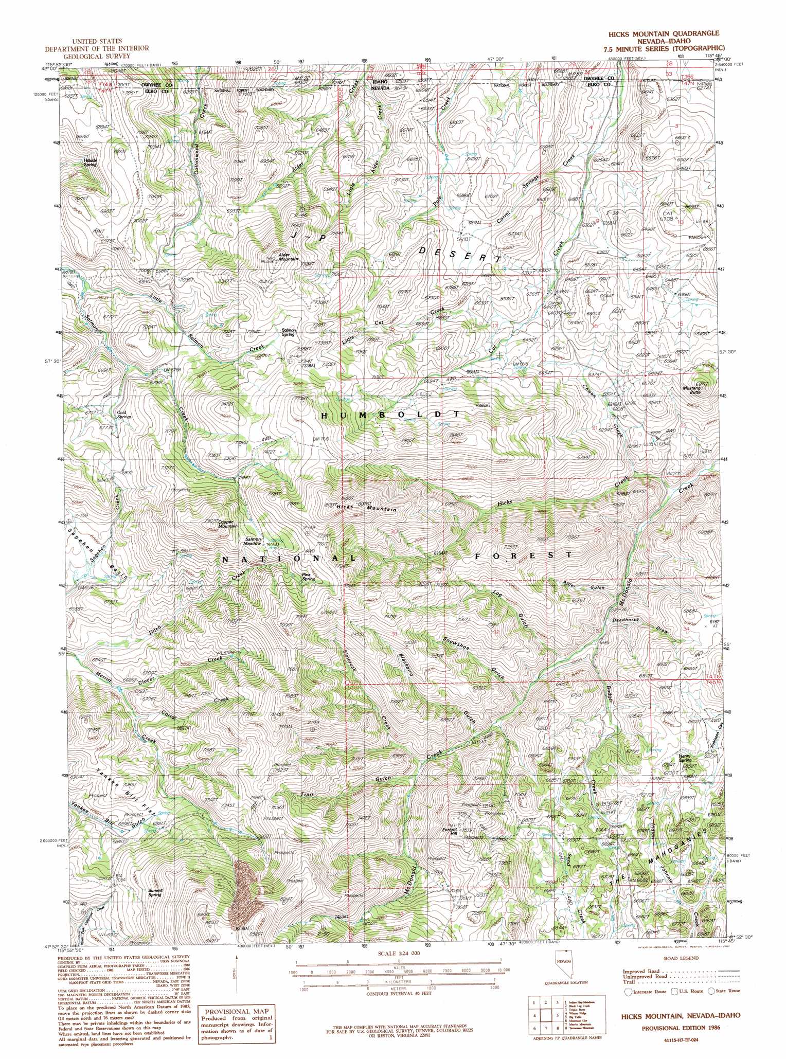
USGS Topo Quad 41115h7 - 1:24,000 scale
| Topo Map Name: | Hicks Mountain |
| USGS Topo Quad ID: | 41115h7 |
| Print Size: | ca. 21 1/4" wide x 27" high |
| Southeast Coordinates: | 41.875° N latitude / 115.75° W longitude |
| Map Center Coordinates: | 41.9375° N latitude / 115.8125° W longitude |
| U.S. States: | NV, ID |
| Filename: | o41115h7.jpg |
| Download Map JPG Image: | Hicks Mountain topo map 1:24,000 scale |
| Map Type: | Topographic |
| Topo Series: | 7.5´ |
| Map Scale: | 1:24,000 |
| Source of Map Images: | United States Geological Survey (USGS) |
| Alternate Map Versions: |
Hicks Mountain NV 1986, updated 1987 Download PDF Buy paper map Hicks Mountain NV 2012 Download PDF Buy paper map Hicks Mountain NV 2014 Download PDF Buy paper map |
| FStopo: | US Forest Service topo Hicks Mountain is available: Download FStopo PDF Download FStopo TIF |
1:24,000 Topo Quads surrounding Hicks Mountain
Riddle |
Buckhorn |
Antelope Creek |
Triguero Lake |
The Arch |
Three Forks |
Indian Hay Meadows |
Black Leg Creek |
Triplet Butte |
Cowan Reservoir |
Owyhee |
Winter Ridge |
Hicks Mountain |
Big Table |
Bearpaw Mountain |
Ungina Wongo |
Mountain City |
Merritt Mountain |
Tennessee Mountain |
Coon Creek |
Maggie Summit |
Badger Creek |
Wild Horse |
Cornwall Mountain |
Annie Creek |
> Back to 41115e1 at 1:100,000 scale
> Back to 41114a1 at 1:250,000 scale
> Back to U.S. Topo Maps home
Hicks Mountain topo map: Gazetteer
Hicks Mountain: Basins
Sagehen Basin elevation 1992m 6535′Hicks Mountain: Flats
Salmon Meadow elevation 2255m 7398′Yankee Bill Flat elevation 2101m 6893′
Hicks Mountain: Gaps
Yankee Bill Summit elevation 2145m 7037′Hicks Mountain: Mines
McDonalds Mine elevation 2068m 6784′Hicks Mountain: Ranges
Bruneau Range elevation 2091m 6860′Hicks Mountain: Springs
Cold Springs elevation 2072m 6797′Henry Spring elevation 2033m 6669′
Hillside Spring elevation 2066m 6778′
Pine Spring elevation 2204m 7230′
Salmon Spring elevation 2177m 7142′
Summit Spring elevation 2212m 7257′
Hicks Mountain: Streams
Badger Creek elevation 1867m 6125′Clover Creek elevation 1987m 6519′
Corral Creek elevation 2000m 6561′
Corral Springs Creek elevation 1868m 6128′
Cowan Creek elevation 1842m 6043′
Ditch Creek elevation 1954m 6410′
Hicks Creek elevation 1797m 5895′
Little Alder Creek elevation 1863m 6112′
Little Alder Creek elevation 1863m 6112′
Little Cat Creek elevation 1943m 6374′
Slaterock Creek elevation 1980m 6496′
Hicks Mountain: Summits
Alder Mountain elevation 2336m 7664′Copper Mountain elevation 2406m 7893′
Enright Hill elevation 2291m 7516′
Hicks Mountain elevation 2491m 8172′
Mustang Butte elevation 2082m 6830′
Hicks Mountain: Valleys
Alder Gulch elevation 1871m 6138′Blackbird Gulch elevation 1937m 6354′
Deadhorse Draw elevation 1861m 6105′
Log Gulch elevation 1880m 6167′
Schoolhouse Draw elevation 1815m 5954′
Snowshoe Gulch elevation 1933m 6341′
Trail Gulch elevation 1987m 6519′
Hicks Mountain digital topo map on disk
Buy this Hicks Mountain topo map showing relief, roads, GPS coordinates and other geographical features, as a high-resolution digital map file on DVD: