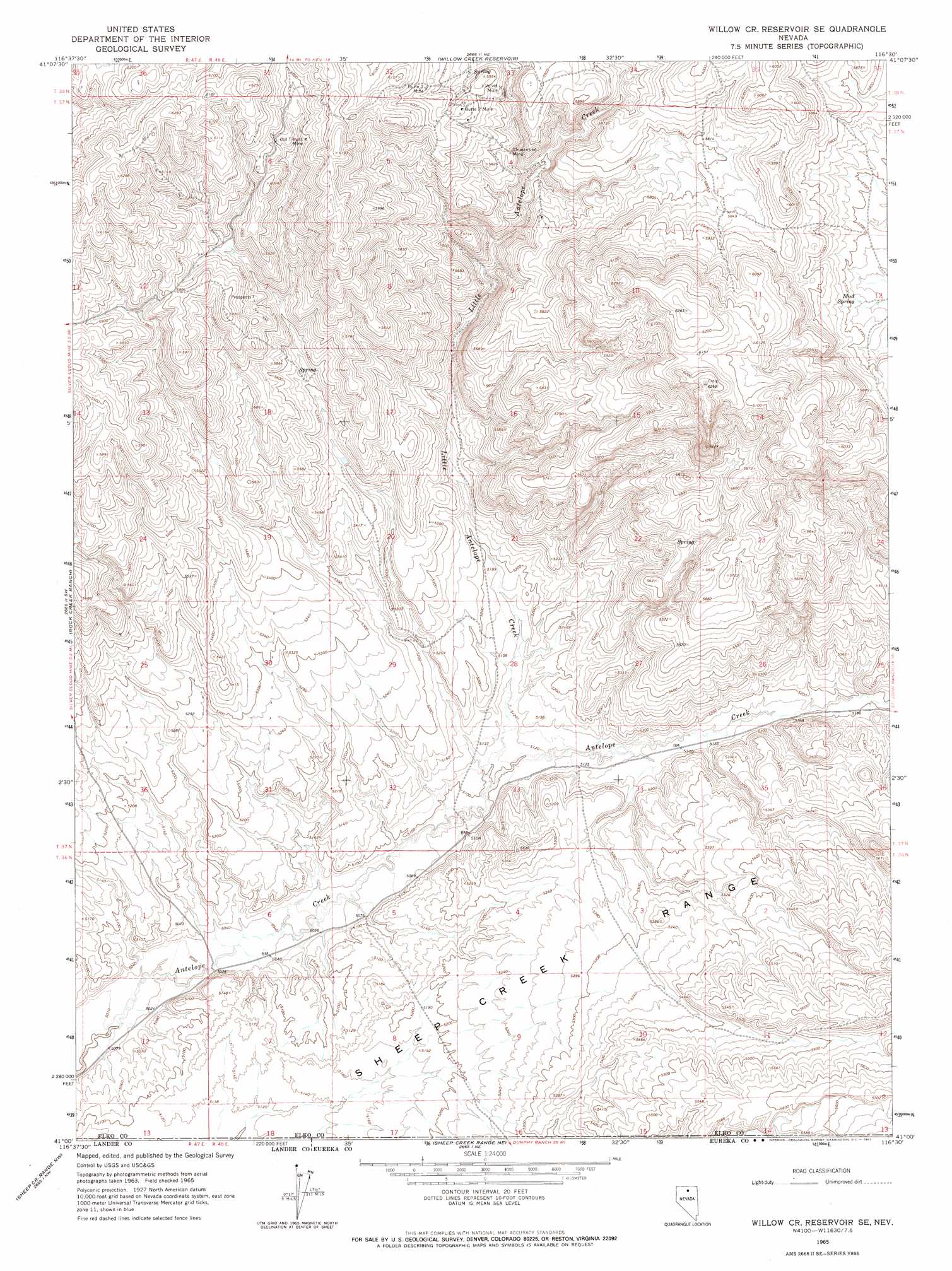
Willow Cr Reservoir Se Topo Map Nevada
To zoom in, hover over the map of Willow Cr Reservoir Se
USGS Topo Quad 41116a5 - 1:24,000 scale
| Topo Map Name: | Willow Cr Reservoir Se |
| USGS Topo Quad ID: | 41116a5 |
| Print Size: | ca. 21 1/4" wide x 27" high |
| Southeast Coordinates: | 41° N latitude / 116.5° W longitude |
| Map Center Coordinates: | 41.0625° N latitude / 116.5625° W longitude |
| U.S. State: | NV |
| Filename: | o41116a5.jpg |
| Download Map JPG Image: | Willow Cr Reservoir Se topo map 1:24,000 scale |
| Map Type: | Topographic |
| Topo Series: | 7.5´ |
| Map Scale: | 1:24,000 |
| Source of Map Images: | United States Geological Survey (USGS) |
| Alternate Map Versions: |
Willow Creek Reservoir SE NV 1965, updated 1967 Download PDF Buy paper map Willow Creek Reservoir SE NV 2012 Download PDF Buy paper map Willow Creek Reservoir SE NV 2014 Download PDF Buy paper map |
1:24,000 Topo Quads surrounding Willow Cr Reservoir Se
Oregon Canyon |
Scraper Springs |
Little Rock Creek |
Toe Jam Mountain |
Mount Blitzen |
Midas |
Squaw Valley Ranch |
Willow Creek Reservoir |
China Camp |
Sugarloaf Butte |
Sixmile Hill |
Rock Creek Ranch |
Willow Cr Reservoir Se |
Santa Renia Fields |
Beaver Peak |
Izzenhood Gap |
Sheep Creek Range Nw |
Sheep Creek Range Ne |
Rodeo Creek Nw |
Rodeo Creek Ne |
Izzenhood Spring |
Sheep Creek Range Sw |
Sheep Creek Range Se |
Rodeo Creek Sw |
Welches Canyon |
> Back to 41116a1 at 1:100,000 scale
> Back to 41116a1 at 1:250,000 scale
> Back to U.S. Topo Maps home
Willow Cr Reservoir Se topo map: Gazetteer
Willow Cr Reservoir Se: Arroyos
Antelope Draw elevation 1535m 5036′Willow Cr Reservoir Se: Mines
Butte One Mine elevation 1806m 5925′Butte Two Mine elevation 1808m 5931′
Clementine Mine elevation 1726m 5662′
Old Timers Mine elevation 1832m 6010′
Velvet Mine elevation 1755m 5757′
Willow Cr Reservoir Se: Springs
Mud Spring elevation 1734m 5688′Willow Cr Reservoir Se: Streams
North Antelope Creek elevation 1552m 5091′Willow Cr Reservoir Se digital topo map on disk
Buy this Willow Cr Reservoir Se topo map showing relief, roads, GPS coordinates and other geographical features, as a high-resolution digital map file on DVD: