Lake Mountain Topo Map Nevada
To zoom in, hover over the map of Lake Mountain
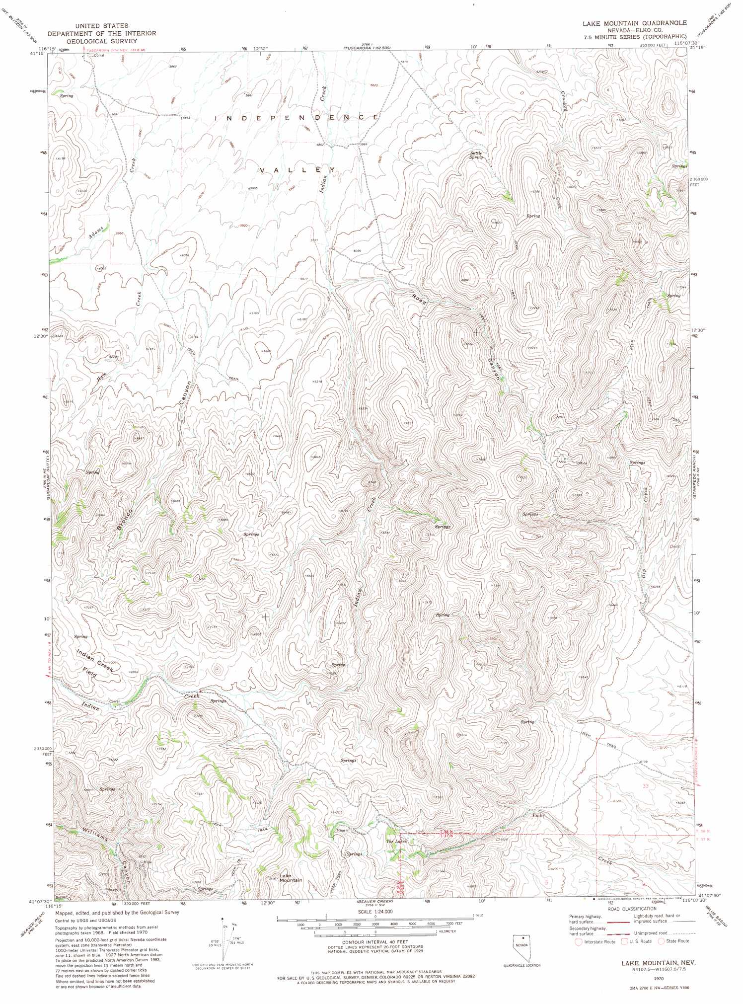
USGS Topo Quad 41116b2 - 1:24,000 scale
| Topo Map Name: | Lake Mountain |
| USGS Topo Quad ID: | 41116b2 |
| Print Size: | ca. 21 1/4" wide x 27" high |
| Southeast Coordinates: | 41.125° N latitude / 116.125° W longitude |
| Map Center Coordinates: | 41.1875° N latitude / 116.1875° W longitude |
| U.S. State: | NV |
| Filename: | o41116b2.jpg |
| Download Map JPG Image: | Lake Mountain topo map 1:24,000 scale |
| Map Type: | Topographic |
| Topo Series: | 7.5´ |
| Map Scale: | 1:24,000 |
| Source of Map Images: | United States Geological Survey (USGS) |
| Alternate Map Versions: |
Lake Mountain NV 1970, updated 1974 Download PDF Buy paper map Lake Mountain NV 1972, updated 1982 Download PDF Buy paper map Lake Mountain NV 2012 Download PDF Buy paper map Lake Mountain NV 2014 Download PDF Buy paper map |
1:24,000 Topo Quads surrounding Lake Mountain
Red Cow Creek |
Big Cottonwood Canyon |
Cottonwood Peak |
Jacks Peak |
California Mountain |
Toe Jam Mountain |
Mount Blitzen |
Tuscarora |
Water Pipe Canyon |
Mahala Creek West |
China Camp |
Sugarloaf Butte |
Lake Mountain |
Stampede Ranch |
Reed Station |
Santa Renia Fields |
Beaver Peak |
Beaver Creek |
Blue Basin |
Singletree Creek |
Rodeo Creek Nw |
Rodeo Creek Ne |
Swales Mountain Nw |
Swales Mountain |
Adobe Summit |
> Back to 41116a1 at 1:100,000 scale
> Back to 41116a1 at 1:250,000 scale
> Back to U.S. Topo Maps home
Lake Mountain topo map: Gazetteer
Lake Mountain: Flats
Indian Creek Field elevation 2161m 7089′Lake Mountain: Lakes
The Lakes elevation 2122m 6961′Lake Mountain: Springs
Suttle Spring elevation 1869m 6131′Lake Mountain: Streams
Ham Creek elevation 1781m 5843′Summit Creek elevation 1826m 5990′
Lake Mountain: Summits
Lake Mountain elevation 2409m 7903′Lake Mountain: Valleys
Bronco Canyon elevation 1793m 5882′Dry Canyon elevation 1789m 5869′
Road Canyon elevation 1826m 5990′
Lake Mountain digital topo map on disk
Buy this Lake Mountain topo map showing relief, roads, GPS coordinates and other geographical features, as a high-resolution digital map file on DVD: