Maggie Summit Topo Map Nevada
To zoom in, hover over the map of Maggie Summit
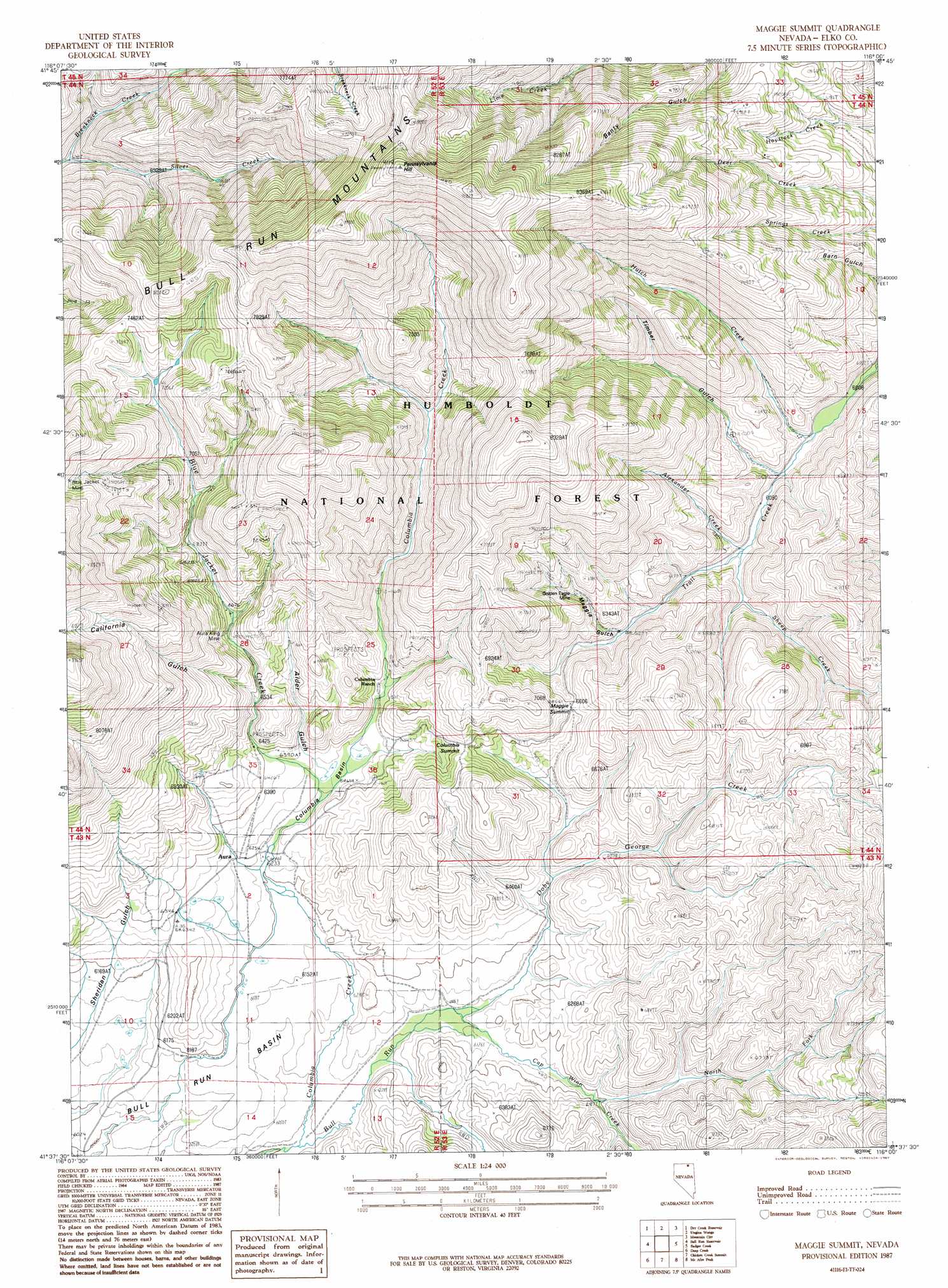
USGS Topo Quad 41116f1 - 1:24,000 scale
| Topo Map Name: | Maggie Summit |
| USGS Topo Quad ID: | 41116f1 |
| Print Size: | ca. 21 1/4" wide x 27" high |
| Southeast Coordinates: | 41.625° N latitude / 116° W longitude |
| Map Center Coordinates: | 41.6875° N latitude / 116.0625° W longitude |
| U.S. State: | NV |
| Filename: | o41116f1.jpg |
| Download Map JPG Image: | Maggie Summit topo map 1:24,000 scale |
| Map Type: | Topographic |
| Topo Series: | 7.5´ |
| Map Scale: | 1:24,000 |
| Source of Map Images: | United States Geological Survey (USGS) |
| Alternate Map Versions: |
Maggie Summit NV 1987, updated 1987 Download PDF Buy paper map Maggie Summit NV 2012 Download PDF Buy paper map Maggie Summit NV 2014 Download PDF Buy paper map |
| FStopo: | US Forest Service topo Maggie Summit is available: Download FStopo PDF Download FStopo TIF |
1:24,000 Topo Quads surrounding Maggie Summit
Groundhog Reservoir |
The Point |
Owyhee |
Winter Ridge |
Hicks Mountain |
Sheep Creek Reservoir |
Dry Creek Reservoir |
Ungina Wongo |
Mountain City |
Merritt Mountain |
Wilson Reservoir |
Bull Run Reservoir |
Maggie Summit |
Badger Creek |
Wild Horse |
Cornucopia Ridge |
Deep Creek |
Chicken Creek Summit |
Mcafee Peak |
Delaware Creek |
Big Cottonwood Canyon |
Cottonwood Peak |
Jacks Peak |
California Mountain |
North Fork |
> Back to 41116e1 at 1:100,000 scale
> Back to 41116a1 at 1:250,000 scale
> Back to U.S. Topo Maps home
Maggie Summit topo map: Gazetteer
Maggie Summit: Basins
Bull Run Basin elevation 1862m 6108′Columbia Basin elevation 1920m 6299′
Maggie Summit: Gaps
Columbia Summit elevation 2034m 6673′Maggie Summit: Mines
Aura King Mine elevation 2130m 6988′Big Four Mine elevation 1976m 6482′
Central Pacific Mine elevation 2152m 7060′
Columbia Queen Mine elevation 1976m 6482′
Golden Eagle Mine elevation 1979m 6492′
Humboldt Mine elevation 2320m 7611′
Infidel Mine elevation 2019m 6624′
Polaris Mine elevation 2178m 7145′
Porter Mine elevation 2152m 7060′
Town Treasure Mine elevation 2152m 7060′
Maggie Summit: Populated Places
Columbia (historical) elevation 1948m 6391′Maggie Summit: Post Offices
Aura Post Office (historical) elevation 1913m 6276′Columbia Post Office (historical) elevation 1948m 6391′
Maggie Summit: Streams
Alexander Creek elevation 1865m 6118′Blue Jacket Creek elevation 1915m 6282′
Cap Winn Creek elevation 1864m 6115′
Columbia Creek elevation 1837m 6026′
Doby George Creek elevation 1864m 6115′
Hutch Creek elevation 1846m 6056′
Maggie Gulch Creek elevation 1911m 6269′
North Fork Cape Winn Creek elevation 1886m 6187′
Sheep Creek elevation 1864m 6115′
Spring Creek elevation 1899m 6230′
Timber Gulch Creek elevation 1854m 6082′
Twin Creek elevation 1881m 6171′
Maggie Summit: Summits
Maggie Summit elevation 2024m 6640′Pennsylvania Hill elevation 2751m 9025′
Maggie Summit: Valleys
Alder Gulch elevation 1919m 6295′California Gulch elevation 2058m 6751′
Maggie Gulch elevation 1919m 6295′
Polaris Gulch elevation 2085m 6840′
Timber Gulch elevation 1855m 6085′
Maggie Summit digital topo map on disk
Buy this Maggie Summit topo map showing relief, roads, GPS coordinates and other geographical features, as a high-resolution digital map file on DVD: