Star Valley Ridge West Topo Map Nevada
To zoom in, hover over the map of Star Valley Ridge West
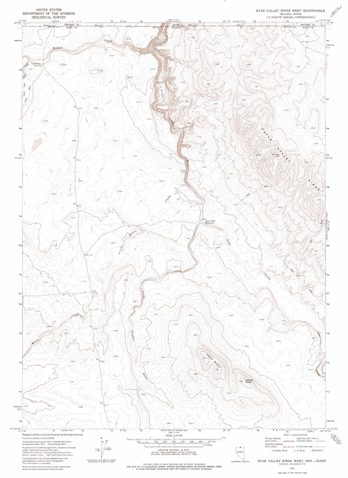
USGS Topo Quad 41116h8 - 1:24,000 scale
| Topo Map Name: | Star Valley Ridge West |
| USGS Topo Quad ID: | 41116h8 |
| Print Size: | ca. 21 1/4" wide x 27" high |
| Southeast Coordinates: | 41.875° N latitude / 116.875° W longitude |
| Map Center Coordinates: | 41.9375° N latitude / 116.9375° W longitude |
| U.S. States: | NV, ID |
| Filename: | o41116h8.jpg |
| Download Map JPG Image: | Star Valley Ridge West topo map 1:24,000 scale |
| Map Type: | Topographic |
| Topo Series: | 7.5´ |
| Map Scale: | 1:24,000 |
| Source of Map Images: | United States Geological Survey (USGS) |
| Alternate Map Versions: |
Star Valley Ridge West NV 1973, updated 1977 Download PDF Buy paper map Star Valley Ridge West NV 2012 Download PDF Buy paper map Star Valley Ridge West NV 2014 Download PDF Buy paper map |
1:24,000 Topo Quads surrounding Star Valley Ridge West
Stoney Corral |
Defeat Butte |
Spring Creek Basin |
Grassy Ridge |
Piute Basin West |
Lookout Lake |
Star Valley Knoll |
Star Valley |
Coyote Hole |
Bull Camp Butte |
Calico Butte |
Nadine Butte |
Star Valley Ridge West |
Star Valley Ridge East |
Rubber Hill |
Maiden Butte |
Maiden Butte Se |
Star Valley Ridge Sw |
Star Valley Ridge Se |
Twelvemile Flat |
Greeley Flat |
Button Lake |
Button Lake Well |
Corral Lake |
Silver Lake |
> Back to 41116e1 at 1:100,000 scale
> Back to 41116a1 at 1:250,000 scale
> Back to U.S. Topo Maps home
Star Valley Ridge West topo map: Gazetteer
Star Valley Ridge West: Reservoirs
Lake Creek Reservoir elevation 1558m 5111′Star Valley Ridge West: Streams
Calico Creek elevation 1554m 5098′Lake Creek elevation 1556m 5104′
Raven Creek elevation 1549m 5082′
Willow Creek elevation 1534m 5032′
Star Valley Ridge West: Summits
Indian Buttes elevation 1669m 5475′Nadine Butte elevation 1654m 5426′
Star Valley Ridge West digital topo map on disk
Buy this Star Valley Ridge West topo map showing relief, roads, GPS coordinates and other geographical features, as a high-resolution digital map file on DVD: