Red House Flat West Topo Map Nevada
To zoom in, hover over the map of Red House Flat West
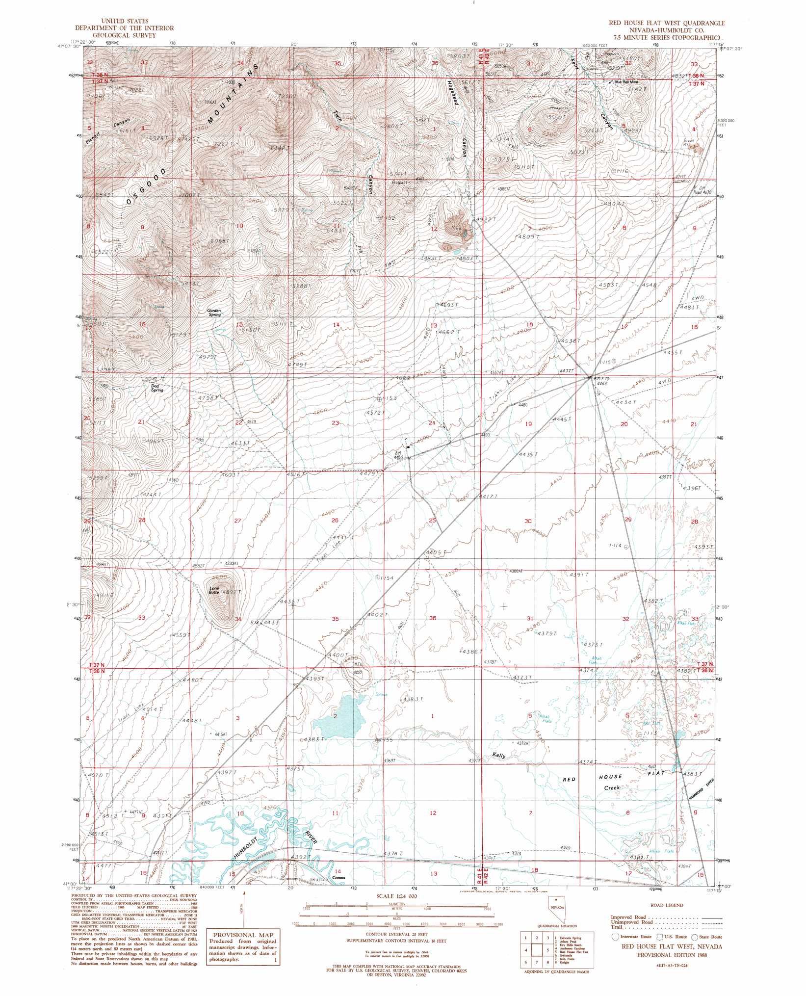
USGS Topo Quad 41117a3 - 1:24,000 scale
| Topo Map Name: | Red House Flat West |
| USGS Topo Quad ID: | 41117a3 |
| Print Size: | ca. 21 1/4" wide x 27" high |
| Southeast Coordinates: | 41° N latitude / 117.25° W longitude |
| Map Center Coordinates: | 41.0625° N latitude / 117.3125° W longitude |
| U.S. State: | NV |
| Filename: | o41117a3.jpg |
| Download Map JPG Image: | Red House Flat West topo map 1:24,000 scale |
| Map Type: | Topographic |
| Topo Series: | 7.5´ |
| Map Scale: | 1:24,000 |
| Source of Map Images: | United States Geological Survey (USGS) |
| Alternate Map Versions: |
Red House Flat West NV 1988, updated 1989 Download PDF Buy paper map Red House Flat West NV 2011 Download PDF Buy paper map Red House Flat West NV 2015 Download PDF Buy paper map |
1:24,000 Topo Quads surrounding Red House Flat West
Willow Point |
Hot Springs Peak |
Eden Valley |
Dry Hills North |
Kenny Creek |
Gumboot Lake |
Delvada Spring |
Adam Peak |
Dry Hills South |
The Knolls |
Golconda Butte |
Anderson Gardens |
Red House Flat West |
Red House Flat East |
Elevenmile Well |
Pole Creek |
Golconda |
Iron Point |
Knight |
Hot Pot |
Adelaide |
Goldrun Creek |
Brooks Spring |
Valmy |
Ellison |
> Back to 41117a1 at 1:100,000 scale
> Back to 41116a1 at 1:250,000 scale
> Back to U.S. Topo Maps home
Red House Flat West topo map: Gazetteer
Red House Flat West: Mines
Barite Mine elevation 1538m 5045′Blue Bell Mine elevation 1566m 5137′
Red House Flat West: Populated Places
Comus elevation 1335m 4379′Red House Flat West: Ranges
Osgood Mountains elevation 2401m 7877′Red House Flat West: Springs
Dog Spring elevation 1525m 5003′Garden Spring elevation 1563m 5127′
Red House Flat West: Streams
Kelly Creek elevation 1334m 4376′Spring Branch elevation 1334m 4376′
Red House Flat West: Summits
Lone Butte elevation 1472m 4829′Red House Flat West: Valleys
Felix Canyon elevation 1504m 4934′Hogshead Canyon elevation 1490m 4888′
Twin Canyon elevation 1384m 4540′
Red House Flat West digital topo map on disk
Buy this Red House Flat West topo map showing relief, roads, GPS coordinates and other geographical features, as a high-resolution digital map file on DVD: