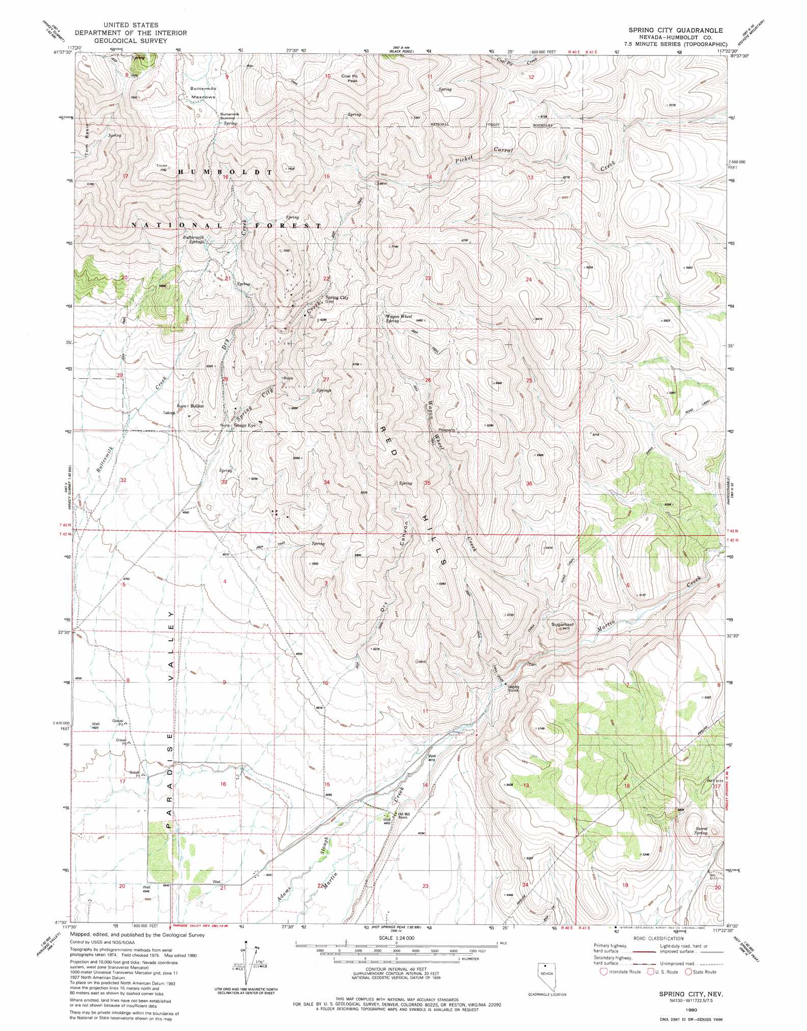
Spring City Topo Map Nevada
To zoom in, hover over the map of Spring City
USGS Topo Quad 41117e4 - 1:24,000 scale
| Topo Map Name: | Spring City |
| USGS Topo Quad ID: | 41117e4 |
| Print Size: | ca. 21 1/4" wide x 27" high |
| Southeast Coordinates: | 41.5° N latitude / 117.375° W longitude |
| Map Center Coordinates: | 41.5625° N latitude / 117.4375° W longitude |
| U.S. State: | NV |
| Filename: | o41117e4.jpg |
| Download Map JPG Image: | Spring City topo map 1:24,000 scale |
| Map Type: | Topographic |
| Topo Series: | 7.5´ |
| Map Scale: | 1:24,000 |
| Source of Map Images: | United States Geological Survey (USGS) |
| Alternate Map Versions: |
Spring City NV 1980, updated 1980 Download PDF Buy paper map Spring City NV 2011 Download PDF Buy paper map Spring City NV 2015 Download PDF Buy paper map |
| FStopo: | US Forest Service topo Spring City is available: Download FStopo PDF Download FStopo TIF |
1:24,000 Topo Quads surrounding Spring City
South Of Mcdermitt |
Buckskin Mountain |
Holloway Meadows |
Capitol Peak |
Maiden Butte |
White Rock Canyon |
Hinkey Summit |
Black Ridge |
Coyote Mountain |
Greeley Flat |
Santa Rosa Peak |
Mullinix Creek |
Spring City |
Hardscrabble |
Whiskey Springs |
Five Fingers |
Paradise Valley |
Little Poverty |
Fairbanks Canyon |
Chimney Reservoir |
Paradise Well |
Willow Point |
Hot Springs Peak |
Eden Valley |
Dry Hills North |
> Back to 41117e1 at 1:100,000 scale
> Back to 41116a1 at 1:250,000 scale
> Back to U.S. Topo Maps home
Spring City topo map: Gazetteer
Spring City: Dams
Sugarloaf Dam elevation 1423m 4668′Spring City: Flats
Buttermilk Meadows elevation 2239m 7345′Spring City: Gaps
Buttermilk Summit elevation 2244m 7362′Spring City: Populated Places
Gouge Eye elevation 1574m 5164′Queen City (historical) elevation 1418m 4652′
Spring City (historical) elevation 1847m 6059′
Spring City: Post Offices
Spring City Post Office (historical) elevation 1847m 6059′Spring City: Ranges
Red Hills elevation 1886m 6187′Spring City: Slopes
China Grade elevation 1448m 4750′Spring City: Springs
Buttermilk Springs elevation 1908m 6259′Secret Spring elevation 1633m 5357′
Wagon Wheel Spring elevation 1886m 6187′
Spring City: Streams
Coal Pit Creek elevation 1845m 6053′Dry Creek elevation 1576m 5170′
Spring City Creek elevation 1397m 4583′
Wagon Wheel Creek elevation 1430m 4691′
Spring City: Summits
Coal Pit Peak elevation 2467m 8093′Sugarloaf elevation 1649m 5410′
Spring City: Trails
China Road elevation 1549m 5082′Spring City: Valleys
Deadman Gulch elevation 1462m 4796′Dry Canyon elevation 1523m 4996′
Spring City Canyon elevation 1528m 5013′
Spring City digital topo map on disk
Buy this Spring City topo map showing relief, roads, GPS coordinates and other geographical features, as a high-resolution digital map file on DVD: