Hays Canyon Topo Map Nevada
To zoom in, hover over the map of Hays Canyon
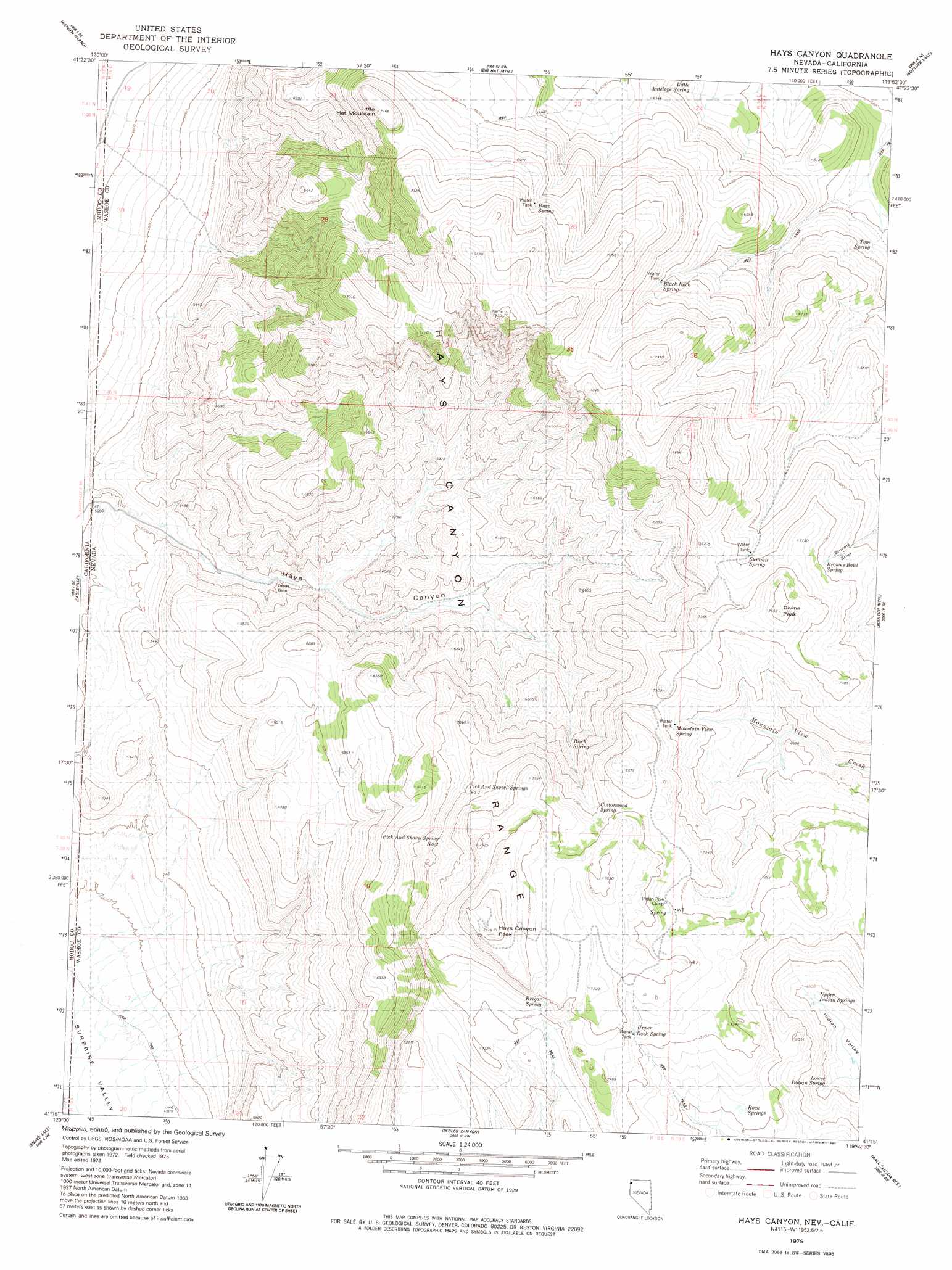
USGS Topo Quad 41119c8 - 1:24,000 scale
| Topo Map Name: | Hays Canyon |
| USGS Topo Quad ID: | 41119c8 |
| Print Size: | ca. 21 1/4" wide x 27" high |
| Southeast Coordinates: | 41.25° N latitude / 119.875° W longitude |
| Map Center Coordinates: | 41.3125° N latitude / 119.9375° W longitude |
| U.S. States: | NV, CA |
| Filename: | o41119c8.jpg |
| Download Map JPG Image: | Hays Canyon topo map 1:24,000 scale |
| Map Type: | Topographic |
| Topo Series: | 7.5´ |
| Map Scale: | 1:24,000 |
| Source of Map Images: | United States Geological Survey (USGS) |
| Alternate Map Versions: |
Hays Canyon NV 1979, updated 1980 Download PDF Buy paper map Hays Canyon NV 2011 Download PDF Buy paper map Hays Canyon NV 2015 Download PDF Buy paper map |
1:24,000 Topo Quads surrounding Hays Canyon
Cedarville |
Leonards Hot Springs |
Fortynine Mountain |
Vya |
Painted Point |
Warren Peak |
Hansen Island |
Big Hat Mountain |
Boulder Lake |
Powers Well |
Eagle Peak |
Eagleville |
Hays Canyon |
Boulder Mountain |
Pinto Springs |
Emerson Peak |
Snake Lake |
Pegleg Canyon |
Wall Canyon Reservoir |
Bordwell Spring |
Boot Lake |
Little Hat Mountain |
Duck Lake |
Juniper Springs |
Lost Creek Pass |
> Back to 41119a1 at 1:100,000 scale
> Back to 41118a1 at 1:250,000 scale
> Back to U.S. Topo Maps home
Hays Canyon topo map: Gazetteer
Hays Canyon: Basins
Browns Bowl elevation 2087m 6847′Hays Canyon: Gaps
Bert Fitz Summit elevation 2176m 7139′Devils Gate elevation 1634m 5360′
Hays Canyon: Ranges
Hays Canyon Range elevation 2174m 7132′Hays Canyon: Springs
Birch Spring elevation 2032m 6666′Black Rock Spring elevation 2021m 6630′
Bregar Spring elevation 2240m 7349′
Browns Bowl Spring elevation 2118m 6948′
Buzz Spring elevation 2123m 6965′
Cottonwood Spring elevation 2198m 7211′
Finley Number Four Spring elevation 1918m 6292′
Finley Number One Spring elevation 1654m 5426′
Finley Number Three Spring elevation 2047m 6715′
Hayes Spring elevation 1818m 5964′
Little Antelope Spring elevation 1860m 6102′
Lower Indian Spring elevation 1998m 6555′
Mountain View Spring elevation 2170m 7119′
Pick and Shovel Spring Number Two elevation 2167m 7109′
Pick and Shovel Springs Number One elevation 2137m 7011′
Rock Springs elevation 2143m 7030′
Summit Spring elevation 2125m 6971′
Tom Spring elevation 1862m 6108′
Upper Indian Springs elevation 2002m 6568′
Upper Rock Spring elevation 2212m 7257′
Hays Canyon: Summits
Divine Peak elevation 2272m 7454′Hays Canyon Peak elevation 2408m 7900′
Little Hat Mountain elevation 2180m 7152′
Hays Canyon digital topo map on disk
Buy this Hays Canyon topo map showing relief, roads, GPS coordinates and other geographical features, as a high-resolution digital map file on DVD: