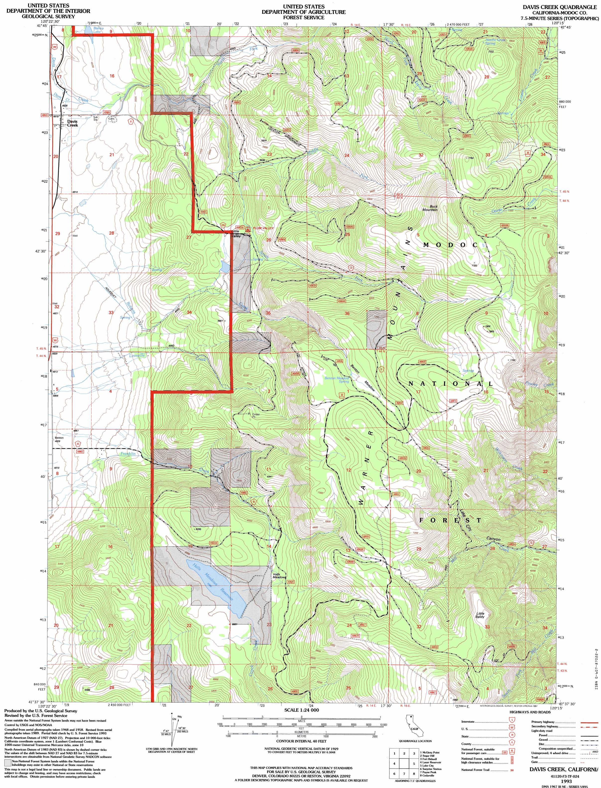
Davis Creek Topo Map California
To zoom in, hover over the map of Davis Creek
USGS Topo Quad 41120f3 - 1:24,000 scale
| Topo Map Name: | Davis Creek |
| USGS Topo Quad ID: | 41120f3 |
| Print Size: | ca. 21 1/4" wide x 27" high |
| Southeast Coordinates: | 41.625° N latitude / 120.25° W longitude |
| Map Center Coordinates: | 41.6875° N latitude / 120.3125° W longitude |
| U.S. State: | CA |
| Filename: | o41120f3.jpg |
| Download Map JPG Image: | Davis Creek topo map 1:24,000 scale |
| Map Type: | Topographic |
| Topo Series: | 7.5´ |
| Map Scale: | 1:24,000 |
| Source of Map Images: | United States Geological Survey (USGS) |
| Alternate Map Versions: |
Davis Creek CA 1990, updated 1990 Download PDF Buy paper map Davis Creek CA 1993, updated 1997 Download PDF Buy paper map Davis Creek CA 2012 Download PDF Buy paper map Davis Creek CA 2015 Download PDF Buy paper map |
| FStopo: | US Forest Service topo Davis Creek is available: Download FStopo PDF Download FStopo TIF |
1:24,000 Topo Quads surrounding Davis Creek
Pease Flat |
West Of Willow Ranch |
Willow Ranch |
Mount Bidwell |
Lake Annie |
Mcginty Reservoir |
Mcginty Point |
Sugar Hill |
Fort Bidwell |
Larkspur Hills |
Dead Horse Reservoir |
Lauer Reservoir |
Davis Creek |
Lake City |
Boyd Hot Spring |
Mahogany Ridge |
Surprise |
Payne Peak |
Cedarville |
Leonards Hot Springs |
Alturas |
Dorris Reservoir |
Shields Creek |
Warren Peak |
Hansen Island |
> Back to 41120e1 at 1:100,000 scale
> Back to 41120a1 at 1:250,000 scale
> Back to U.S. Topo Maps home
Davis Creek topo map: Gazetteer
Davis Creek: Basins
Little Valley elevation 1722m 5649′Davis Creek: Flats
Benton Meadow elevation 2160m 7086′Halls Meadows elevation 1842m 6043′
Davis Creek: Lakes
Bishop Lake elevation 1495m 4904′Davis Creek: Populated Places
Davis Creek elevation 1477m 4845′Davis Creek: Reservoirs
Halls Meadows Reservoir elevation 1829m 6000′Davis Creek: Springs
Benton Meadow Spring elevation 2157m 7076′Needle Grass Spring elevation 2137m 7011′
Davis Creek: Streams
Middle Fork Davis Creek elevation 1653m 5423′North Fork Davis Creek elevation 1742m 5715′
South Fork Davis Creek elevation 1576m 5170′
Davis Creek: Summits
Buck Mountain elevation 2417m 7929′Little Baldy elevation 2253m 7391′
Davis Creek digital topo map on disk
Buy this Davis Creek topo map showing relief, roads, GPS coordinates and other geographical features, as a high-resolution digital map file on DVD: