Dead Horse Reservoir Topo Map California
To zoom in, hover over the map of Dead Horse Reservoir
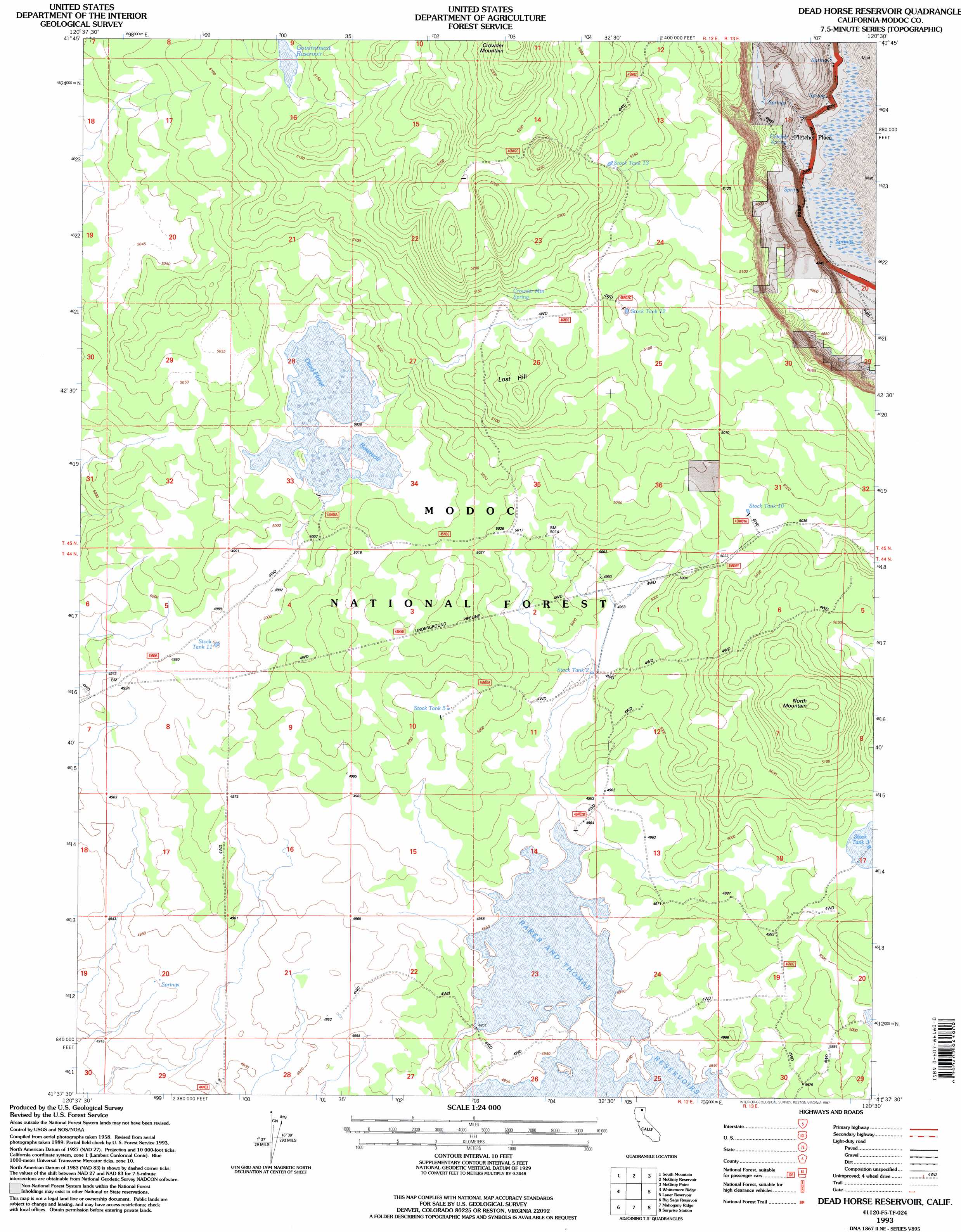
USGS Topo Quad 41120f5 - 1:24,000 scale
| Topo Map Name: | Dead Horse Reservoir |
| USGS Topo Quad ID: | 41120f5 |
| Print Size: | ca. 21 1/4" wide x 27" high |
| Southeast Coordinates: | 41.625° N latitude / 120.5° W longitude |
| Map Center Coordinates: | 41.6875° N latitude / 120.5625° W longitude |
| U.S. State: | CA |
| Filename: | o41120f5.jpg |
| Download Map JPG Image: | Dead Horse Reservoir topo map 1:24,000 scale |
| Map Type: | Topographic |
| Topo Series: | 7.5´ |
| Map Scale: | 1:24,000 |
| Source of Map Images: | United States Geological Survey (USGS) |
| Alternate Map Versions: |
Dead Horse Reservoir CA 1990, updated 1990 Download PDF Buy paper map Dead Horse Reservoir CA 1993, updated 1997 Download PDF Buy paper map Dead Horse Reservoir CA 2012 Download PDF Buy paper map Dead Horse Reservoir CA 2015 Download PDF Buy paper map |
| FStopo: | US Forest Service topo Dead Horse Reservoir is available: Download FStopo PDF Download FStopo TIF |
1:24,000 Topo Quads surrounding Dead Horse Reservoir
Weed Valley |
Beaver Mountain |
Pease Flat |
West Of Willow Ranch |
Willow Ranch |
Hager Basin |
South Mountain |
Mcginty Reservoir |
Mcginty Point |
Sugar Hill |
Boles Meadows East |
Whittemore Ridge |
Dead Horse Reservoir |
Lauer Reservoir |
Davis Creek |
Jacks Butte |
Big Sage Reservoir |
Mahogany Ridge |
Surprise |
Payne Peak |
Canby |
Rattlesnake Butte |
Alturas |
Dorris Reservoir |
Shields Creek |
> Back to 41120e1 at 1:100,000 scale
> Back to 41120a1 at 1:250,000 scale
> Back to U.S. Topo Maps home
Dead Horse Reservoir topo map: Gazetteer
Dead Horse Reservoir: Dams
Big Dobe North 129 Dam elevation 1508m 4947′Dead Horse Reservoir: Populated Places
Fletcher Place elevation 1450m 4757′Dead Horse Reservoir: Reservoirs
Dead Horse Reservoir elevation 1530m 5019′Government Reservoir elevation 1563m 5127′
Stock Tank 10 elevation 1536m 5039′
Stock Tank 11 elevation 1522m 4993′
Stock Tank 12 elevation 1559m 5114′
Stock Tank 13 elevation 1573m 5160′
Stock Tank 2 elevation 1519m 4983′
Stock Tank 3 elevation 1526m 5006′
Stock Tank 5 elevation 1525m 5003′
Dead Horse Reservoir: Springs
Crowder Mountain Spring elevation 1566m 5137′Fletcher Spring elevation 1446m 4744′
Dead Horse Reservoir: Summits
Lost Hill elevation 1573m 5160′North Mountain elevation 1571m 5154′
Dead Horse Reservoir digital topo map on disk
Buy this Dead Horse Reservoir topo map showing relief, roads, GPS coordinates and other geographical features, as a high-resolution digital map file on DVD: