Pittville Topo Map California
To zoom in, hover over the map of Pittville
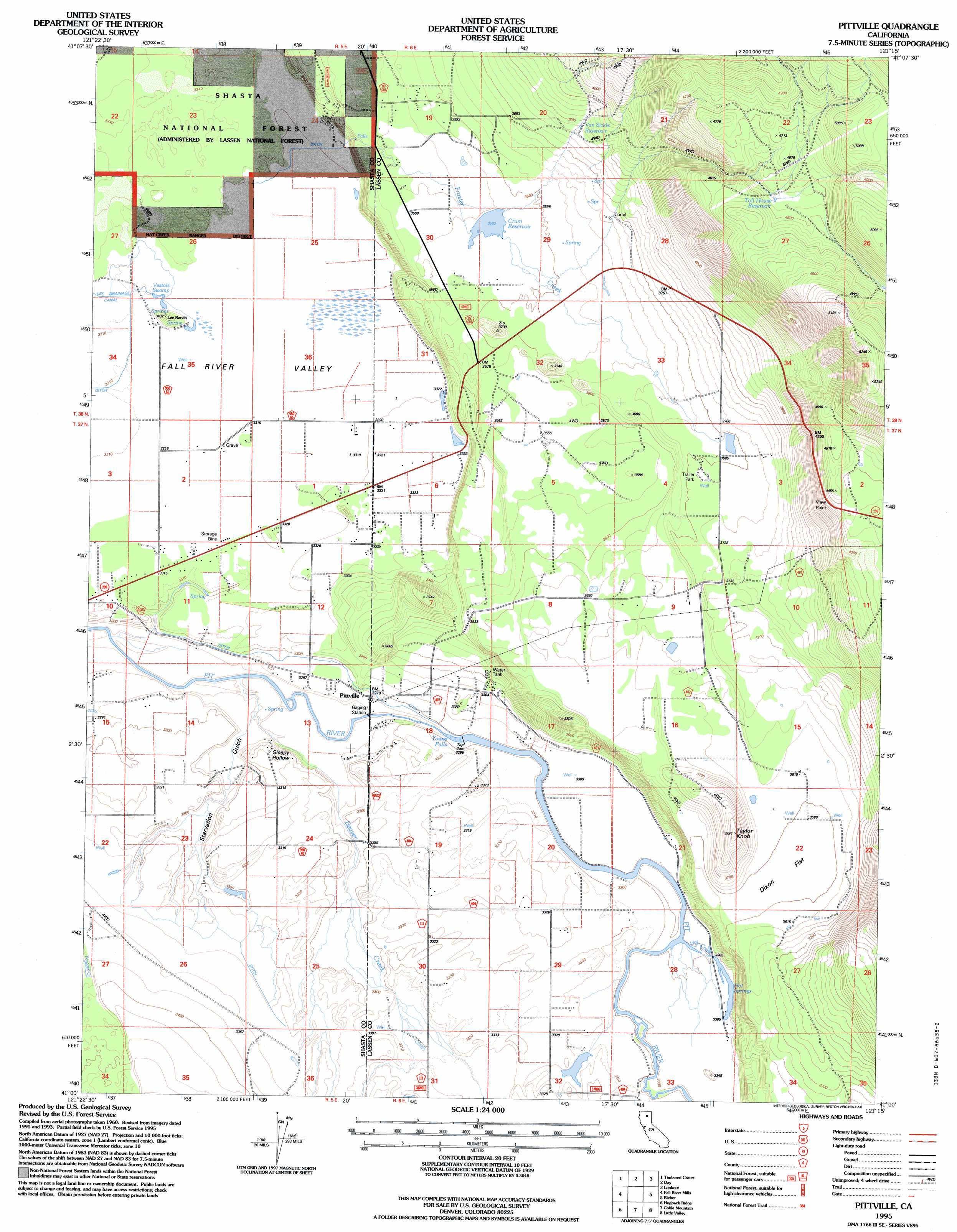
USGS Topo Quad 41121a3 - 1:24,000 scale
| Topo Map Name: | Pittville |
| USGS Topo Quad ID: | 41121a3 |
| Print Size: | ca. 21 1/4" wide x 27" high |
| Southeast Coordinates: | 41° N latitude / 121.25° W longitude |
| Map Center Coordinates: | 41.0625° N latitude / 121.3125° W longitude |
| U.S. State: | CA |
| Filename: | o41121a3.jpg |
| Download Map JPG Image: | Pittville topo map 1:24,000 scale |
| Map Type: | Topographic |
| Topo Series: | 7.5´ |
| Map Scale: | 1:24,000 |
| Source of Map Images: | United States Geological Survey (USGS) |
| Alternate Map Versions: |
Pittville CA 1990, updated 1990 Download PDF Buy paper map Pittville CA 1995, updated 1998 Download PDF Buy paper map Pittville CA 2012 Download PDF Buy paper map Pittville CA 2015 Download PDF Buy paper map |
| FStopo: | US Forest Service topo Pittville is available: Download FStopo PDF Download FStopo TIF |
1:24,000 Topo Quads surrounding Pittville
Indian Spring Mountain |
Whitehorse |
Egg Lake |
Donica Mountain |
Halls Canyon |
East Of Pondosa |
Timbered Crater |
Day |
Lookout |
Big Swamp |
Dana |
Fall River Mills |
Pittville |
Bieber |
Hog Valley |
Cassel |
Hogback Ridge |
Coble Mountain |
Little Valley |
Dixie Peak |
Burney Mountain East |
Murken Bench |
Jellico |
Corders Reservoir |
Straylor Lake |
> Back to 41121a1 at 1:100,000 scale
> Back to 41120a1 at 1:250,000 scale
> Back to U.S. Topo Maps home
Pittville topo map: Gazetteer
Pittville: Dams
Crum 1251 Dam elevation 1093m 3585′Mead Reservoir 1258 Dam elevation 1015m 3330′
Pittville: Falls
Young Falls elevation 1002m 3287′Pittville: Flats
Dixon Flat elevation 1096m 3595′Pittville: Populated Places
Pittville elevation 1001m 3284′Pittville: Reservoirs
Crum Reservoir elevation 1093m 3585′Toll House Reservoir elevation 1392m 4566′
Van Sickle Reservoir elevation 1154m 3786′
Pittville: Springs
Hot Springs elevation 1009m 3310′Pittville: Streams
Beaver Creek elevation 988m 3241′Frazier Creek elevation 1012m 3320′
Hot Creek elevation 1006m 3300′
Pittville: Summits
Taylor Knob elevation 1192m 3910′Pittville: Swamps
Vestals Swamp elevation 1011m 3316′Pittville: Valleys
Sleepy Hollow elevation 990m 3248′Starvation Gulch elevation 989m 3244′
Pittville digital topo map on disk
Buy this Pittville topo map showing relief, roads, GPS coordinates and other geographical features, as a high-resolution digital map file on DVD: