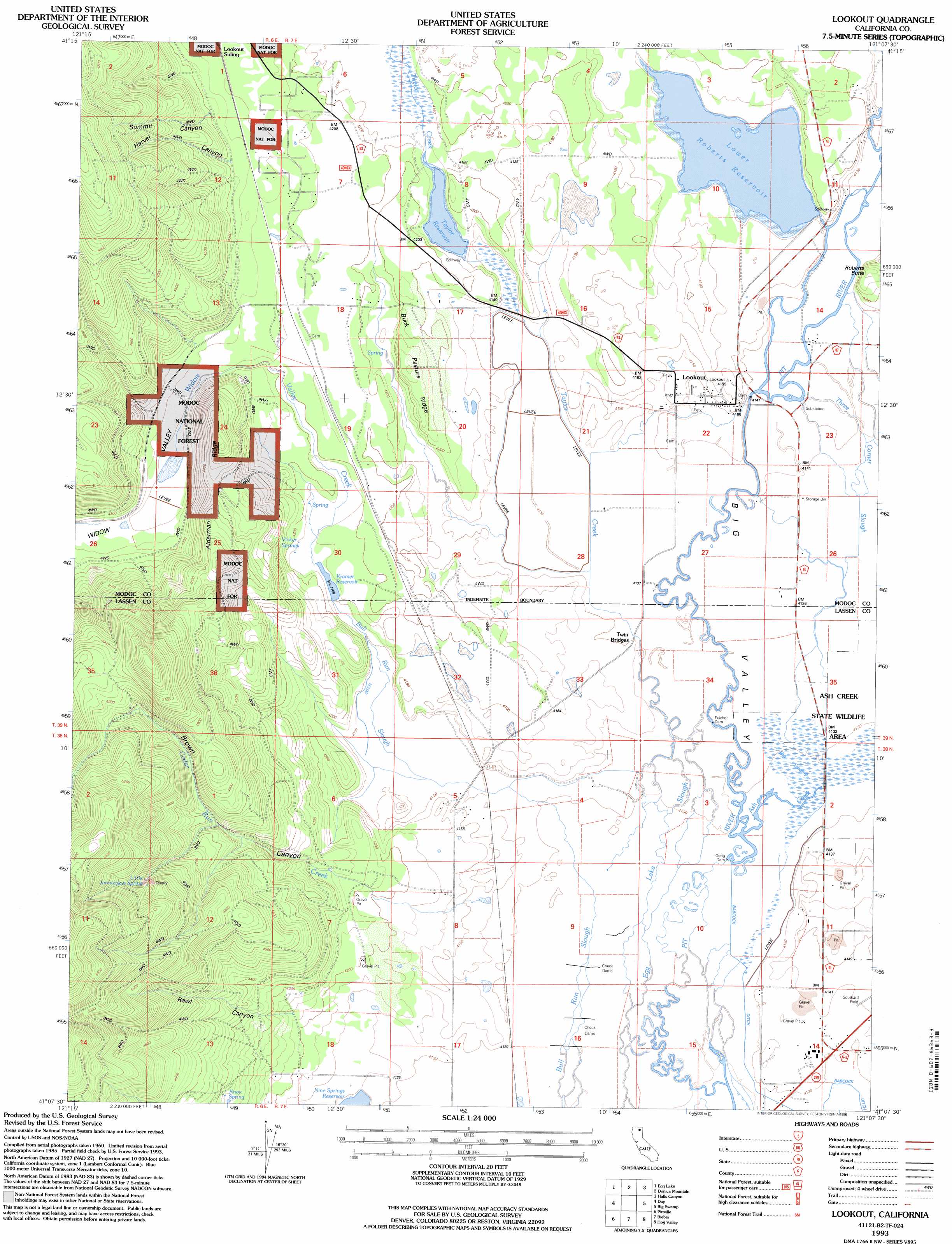
Lookout Topo Map California
To zoom in, hover over the map of Lookout
USGS Topo Quad 41121b2 - 1:24,000 scale
| Topo Map Name: | Lookout |
| USGS Topo Quad ID: | 41121b2 |
| Print Size: | ca. 21 1/4" wide x 27" high |
| Southeast Coordinates: | 41.125° N latitude / 121.125° W longitude |
| Map Center Coordinates: | 41.1875° N latitude / 121.1875° W longitude |
| U.S. State: | CA |
| Filename: | o41121b2.jpg |
| Download Map JPG Image: | Lookout topo map 1:24,000 scale |
| Map Type: | Topographic |
| Topo Series: | 7.5´ |
| Map Scale: | 1:24,000 |
| Source of Map Images: | United States Geological Survey (USGS) |
| Alternate Map Versions: |
Lookout CA 1990, updated 1990 Download PDF Buy paper map Lookout CA 1993, updated 1996 Download PDF Buy paper map Lookout CA 2012 Download PDF Buy paper map Lookout CA 2015 Download PDF Buy paper map |
| FStopo: | US Forest Service topo Lookout is available: Download FStopo PDF Download FStopo TIF |
1:24,000 Topo Quads surrounding Lookout
Border Mountain |
Hollenbeck |
Crank Mountain |
Happy Camp Mountain |
Washington Mountain |
Whitehorse |
Egg Lake |
Donica Mountain |
Halls Canyon |
Adin Pass |
Timbered Crater |
Day |
Lookout |
Big Swamp |
Adin |
Fall River Mills |
Pittville |
Bieber |
Hog Valley |
Letterbox Hill |
Hogback Ridge |
Coble Mountain |
Little Valley |
Dixie Peak |
Silva Flat Reservoir |
> Back to 41121a1 at 1:100,000 scale
> Back to 41120a1 at 1:250,000 scale
> Back to U.S. Topo Maps home
Lookout topo map: Gazetteer
Lookout: Canals
Babcock Ditch elevation 1259m 4130′Oilar Ditch elevation 1262m 4140′
Lookout: Dams
Fulcher Dam elevation 1260m 4133′Gerig Dam elevation 1259m 4130′
Kramer 156-006 Dam elevation 1272m 4173′
Lookout 164 Dam elevation 1263m 4143′
Roberts 157-002 Dam elevation 1267m 4156′
Taylor Creek Number 1 114 Dam elevation 1265m 4150′
Lookout: Populated Places
Lookout elevation 1263m 4143′Lookout: Ranges
Widow Valley Mountains elevation 1404m 4606′Lookout: Reservoirs
Kramer Reservoir elevation 1272m 4173′Lower Roberts Reservoir elevation 1267m 4156′
Taylor Reservoir elevation 1265m 4150′
Lookout: Ridges
Alderman Ridge elevation 1354m 4442′Buck Pasture Ridge elevation 1293m 4242′
Lookout: Springs
Knox Spring elevation 1335m 4379′Little Jimmerson Spring elevation 1497m 4911′
Vicker Springs elevation 1277m 4189′
Lookout: Streams
Ash Creek elevation 1259m 4130′Cedar Run Creek elevation 1264m 4146′
Taylor Creek elevation 1262m 4140′
Three Corner Slough elevation 1263m 4143′
Turner Creek elevation 1266m 4153′
Widow Valley Creek elevation 1273m 4176′
Lookout: Valleys
Brown Canyon elevation 1278m 4192′Harvel Canyon elevation 1311m 4301′
Rawl Canyon elevation 1294m 4245′
Summit Canyon elevation 1315m 4314′
Widow Valley elevation 1293m 4242′
Lookout digital topo map on disk
Buy this Lookout topo map showing relief, roads, GPS coordinates and other geographical features, as a high-resolution digital map file on DVD: