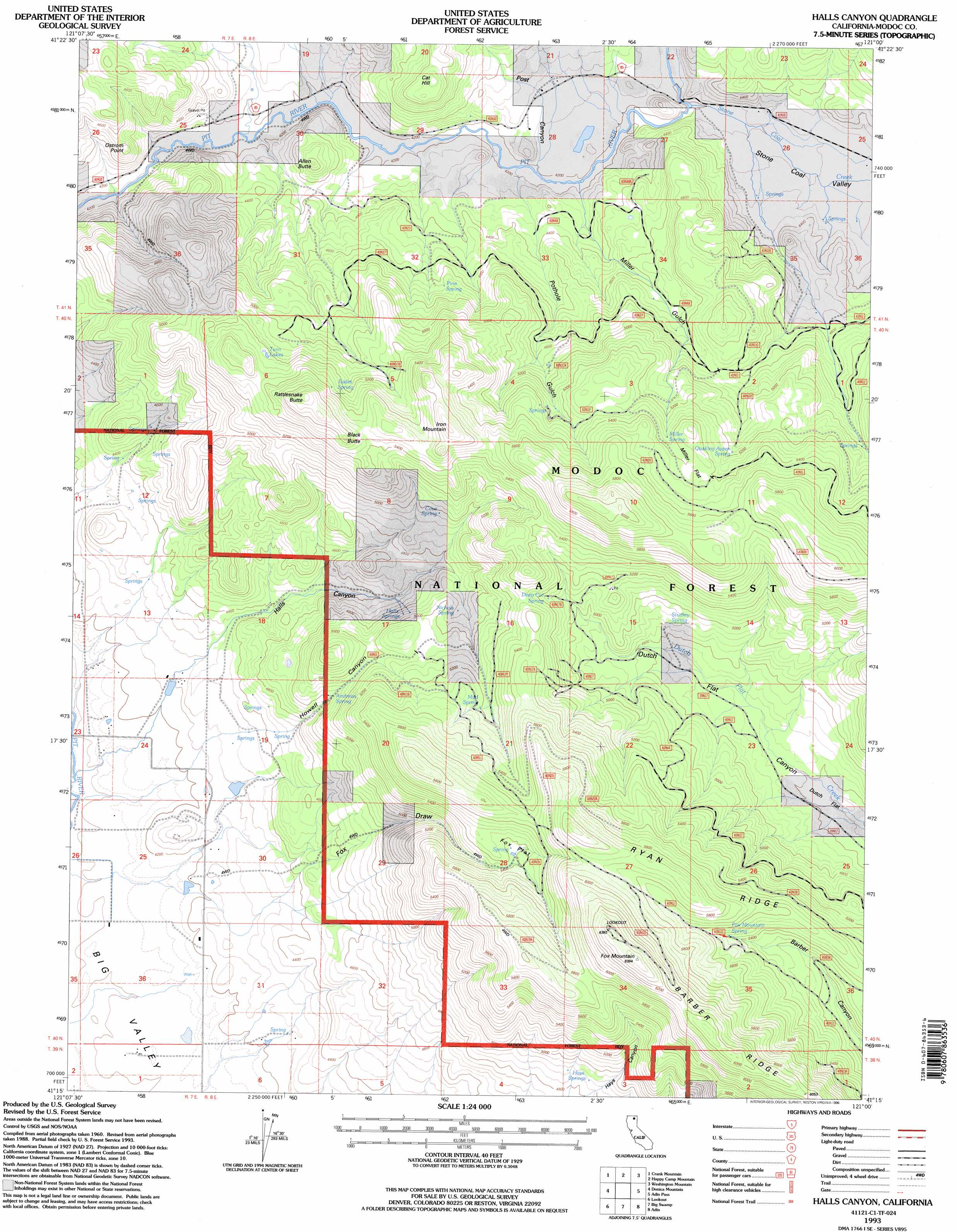
Halls Canyon Topo Map California
To zoom in, hover over the map of Halls Canyon
USGS Topo Quad 41121c1 - 1:24,000 scale
| Topo Map Name: | Halls Canyon |
| USGS Topo Quad ID: | 41121c1 |
| Print Size: | ca. 21 1/4" wide x 27" high |
| Southeast Coordinates: | 41.25° N latitude / 121° W longitude |
| Map Center Coordinates: | 41.3125° N latitude / 121.0625° W longitude |
| U.S. State: | CA |
| Filename: | o41121c1.jpg |
| Download Map JPG Image: | Halls Canyon topo map 1:24,000 scale |
| Map Type: | Topographic |
| Topo Series: | 7.5´ |
| Map Scale: | 1:24,000 |
| Source of Map Images: | United States Geological Survey (USGS) |
| Alternate Map Versions: |
Halls Canyon CA 1990, updated 1990 Download PDF Buy paper map Halls Canyon CA 1993, updated 1996 Download PDF Buy paper map Halls Canyon CA 2012 Download PDF Buy paper map Halls Canyon CA 2015 Download PDF Buy paper map |
| FStopo: | US Forest Service topo Halls Canyon is available: Download FStopo PDF Download FStopo TIF |
1:24,000 Topo Quads surrounding Halls Canyon
Kephart |
Spaulding Butte |
Knobcone Butte |
Ambrose |
Jacks Butte |
Hollenbeck |
Crank Mountain |
Happy Camp Mountain |
Washington Mountain |
Canby |
Egg Lake |
Donica Mountain |
Halls Canyon |
Adin Pass |
Hermit Butte |
Day |
Lookout |
Big Swamp |
Adin |
Ambrose Valley |
Pittville |
Bieber |
Hog Valley |
Letterbox Hill |
Lane Reservoir |
> Back to 41121a1 at 1:100,000 scale
> Back to 41120a1 at 1:250,000 scale
> Back to U.S. Topo Maps home
Halls Canyon topo map: Gazetteer
Halls Canyon: Flats
Dutch Flat elevation 1392m 4566′Fox Flat elevation 1646m 5400′
Miller Flat elevation 1659m 5442′
Halls Canyon: Lakes
Twin Lakes elevation 1594m 5229′Halls Canyon: Springs
Andrews Spring elevation 1459m 4786′Cove Spring elevation 1516m 4973′
Deep Cut Spring elevation 1574m 5164′
Eades Spring elevation 1619m 5311′
Fox Mountain Spring elevation 1670m 5479′
Halls Springs elevation 1500m 4921′
Hays Springs elevation 1478m 4849′
Miller Spring elevation 1629m 5344′
Mud Spring elevation 1583m 5193′
Nichols Spring elevation 1498m 4914′
Pine Spring elevation 1425m 4675′
Quaking Aspen Spring elevation 1575m 5167′
Studley Spring elevation 1480m 4855′
Halls Canyon: Streams
Stone Coal Creek elevation 1281m 4202′Stone Coal Valley elevation 1291m 4235′
Halls Canyon: Summits
Allen Butte elevation 1392m 4566′Black Butte elevation 1721m 5646′
Cat Hill elevation 1504m 4934′
Fox Mountain elevation 1943m 6374′
Iron Mountain elevation 1759m 5770′
Ostrom Point elevation 1405m 4609′
Rattlesnake Butte elevation 1760m 5774′
Halls Canyon: Valleys
Fox Draw elevation 1280m 4199′Halls Canyon elevation 1304m 4278′
Howell Canyon elevation 1346m 4416′
Miller Gulch elevation 1302m 4271′
Post Canyon elevation 1312m 4304′
Pothole Gulch elevation 1298m 4258′
Halls Canyon digital topo map on disk
Buy this Halls Canyon topo map showing relief, roads, GPS coordinates and other geographical features, as a high-resolution digital map file on DVD: