Copic Topo Map California
To zoom in, hover over the map of Copic
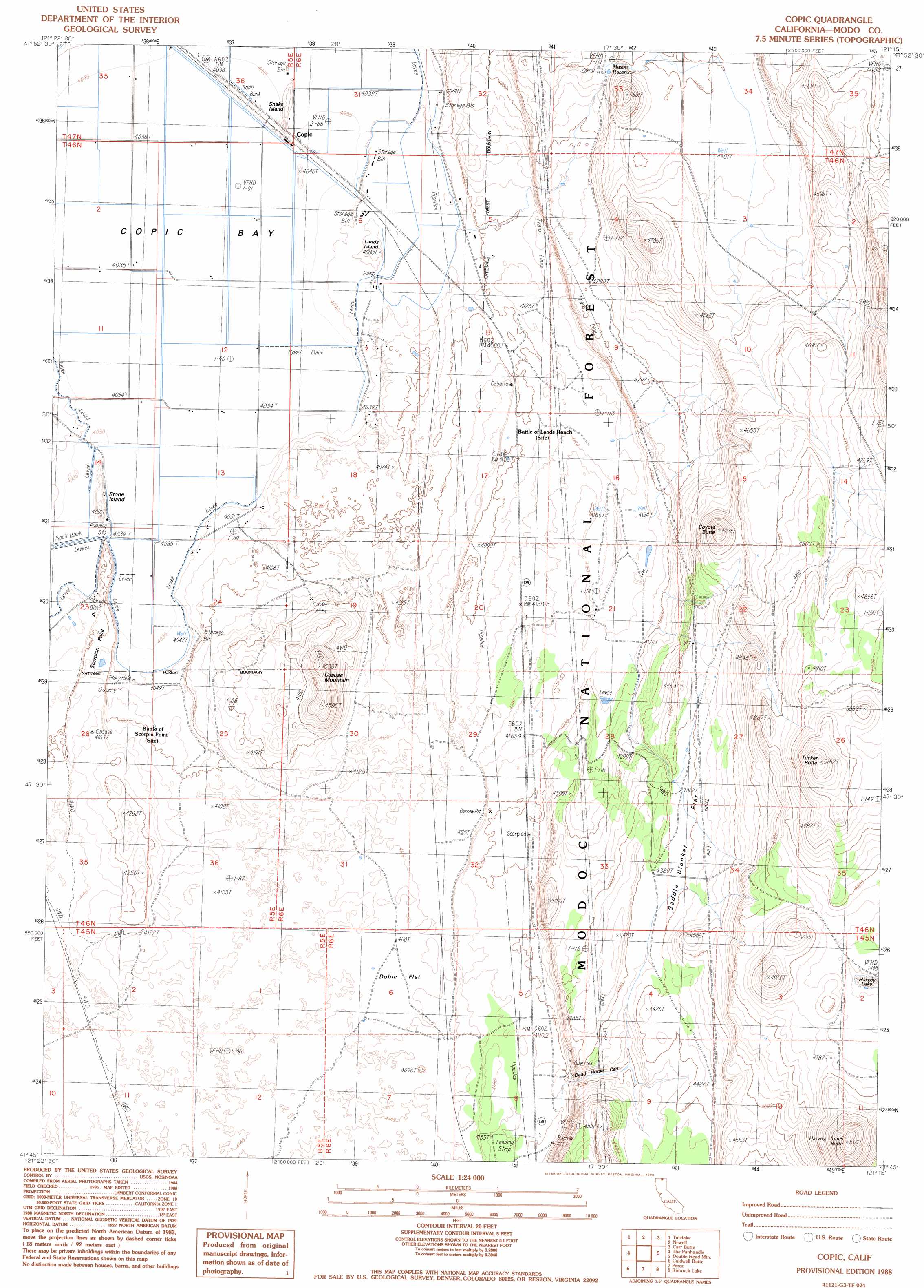
USGS Topo Quad 41121g3 - 1:24,000 scale
| Topo Map Name: | Copic |
| USGS Topo Quad ID: | 41121g3 |
| Print Size: | ca. 21 1/4" wide x 27" high |
| Southeast Coordinates: | 41.75° N latitude / 121.25° W longitude |
| Map Center Coordinates: | 41.8125° N latitude / 121.3125° W longitude |
| U.S. State: | CA |
| Filename: | o41121g3.jpg |
| Download Map JPG Image: | Copic topo map 1:24,000 scale |
| Map Type: | Topographic |
| Topo Series: | 7.5´ |
| Map Scale: | 1:24,000 |
| Source of Map Images: | United States Geological Survey (USGS) |
| Alternate Map Versions: |
Copic CA 1988, updated 1988 Download PDF Buy paper map Copic CA 1993, updated 1996 Download PDF Buy paper map Copic CA 2012 Download PDF Buy paper map Copic CA 2015 Download PDF Buy paper map |
| FStopo: | US Forest Service topo Copic is available: Download FStopo PDF Download FStopo TIF |
1:24,000 Topo Quads surrounding Copic
Merrill |
Malin |
Bryant Mountain |
Langell Valley |
Brady Butte |
Hatfield |
Tulelake |
Newell |
Carr Butte |
Sagebrush Butte |
Captain Jacks Stronghold |
The Panhandle |
Copic |
Double Head Mountain |
Pinnacle Lake |
Schonchin Butte |
Caldwell Butte |
Perez |
Rimrock Lake |
Lone Pine Butte |
Medicine Lake |
West Of Kephart |
Kephart |
Spaulding Butte |
Knobcone Butte |
> Back to 41121e1 at 1:100,000 scale
> Back to 41120a1 at 1:250,000 scale
> Back to U.S. Topo Maps home
Copic topo map: Gazetteer
Copic: Areas
Copic Bay elevation 1231m 4038′Copic: Capes
Scorpion Point elevation 1239m 4064′Copic: Flats
Dobie Flat elevation 1257m 4124′Saddle Blanket Flat elevation 1340m 4396′
Copic: Islands
Lands Island elevation 1241m 4071′Snake Island elevation 1231m 4038′
Stone Island elevation 1240m 4068′
Copic: Lakes
Harvey Lake elevation 1445m 4740′Copic: Populated Places
Copic elevation 1231m 4038′Cornell elevation 1257m 4124′
Copic: Reservoirs
Mason Reservoir elevation 1332m 4370′Copic: Summits
Casuse Mountain elevation 1365m 4478′Coyote Butte elevation 1455m 4773′
Harvey Jones Butte elevation 1575m 5167′
Tucker Butte elevation 1580m 5183′
Copic: Trails
Petroglyph Point Trail elevation 1238m 4061′Copic: Valleys
Dead Horse Canyon elevation 1304m 4278′Copic digital topo map on disk
Buy this Copic topo map showing relief, roads, GPS coordinates and other geographical features, as a high-resolution digital map file on DVD: