Lake Mccloud Topo Map California
To zoom in, hover over the map of Lake Mccloud
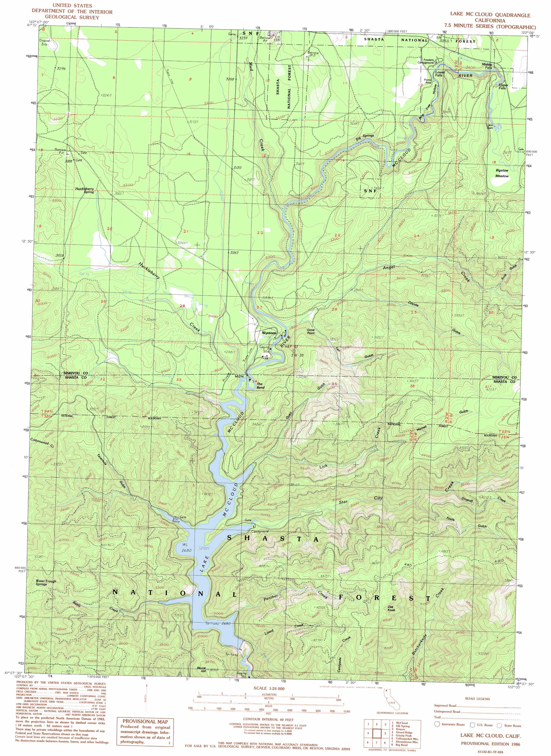
USGS Topo Quad 41122b1 - 1:24,000 scale
| Topo Map Name: | Lake Mccloud |
| USGS Topo Quad ID: | 41122b1 |
| Print Size: | ca. 21 1/4" wide x 27" high |
| Southeast Coordinates: | 41.125° N latitude / 122° W longitude |
| Map Center Coordinates: | 41.1875° N latitude / 122.0625° W longitude |
| U.S. State: | CA |
| Filename: | o41122b1.jpg |
| Download Map JPG Image: | Lake Mccloud topo map 1:24,000 scale |
| Map Type: | Topographic |
| Topo Series: | 7.5´ |
| Map Scale: | 1:24,000 |
| Source of Map Images: | United States Geological Survey (USGS) |
| Alternate Map Versions: |
Lake McCloud CA 1986, updated 1986 Download PDF Buy paper map Lake McCloud CA 1986, updated 1986 Download PDF Buy paper map Lake McCloud CA 1998, updated 2003 Download PDF Buy paper map Lake McCloud CA 2012 Download PDF Buy paper map Lake McCloud CA 2015 Download PDF Buy paper map |
| FStopo: | US Forest Service topo Lake McCloud is available: Download FStopo PDF Download FStopo TIF |
1:24,000 Topo Quads surrounding Lake Mccloud
Hotlum |
Mount Shasta |
Ash Creek Butte |
Rainbow Mountain |
Horse Peak |
City Of Mount Shasta |
Mccloud |
Elk Spring |
Kinyon |
Bartle |
Dunsmuir |
Girard Ridge |
Lake Mccloud |
Grizzly Peak |
Dead Horse Summit |
Tombstone Mountain |
Yellowjacket Mountain |
Shoeinhorse Mountain |
Big Bend |
Skunk Ridge |
Hanland Peak |
Bollibokka Mountain |
Goose Gap |
Roaring Creek |
Chalk Mountain |
> Back to 41122a1 at 1:100,000 scale
> Back to 41122a1 at 1:250,000 scale
> Back to U.S. Topo Maps home
Lake Mccloud topo map: Gazetteer
Lake Mccloud: Bends
The Bend elevation 818m 2683′Lake Mccloud: Capes
Cone Point elevation 983m 3225′Lake Mccloud: Dams
Lakin Dam elevation 1076m 3530′McCloud 97-123 Dam elevation 807m 2647′
Lake Mccloud: Falls
Lower Falls elevation 989m 3244′Middle Falls elevation 1032m 3385′
Upper Falls elevation 1047m 3435′
Lake Mccloud: Flats
Bigelow Meadow elevation 1080m 3543′Lake Mccloud: Populated Places
Rinckel elevation 818m 2683′Wyntoon elevation 868m 2847′
Lake Mccloud: Reservoirs
Lake McCloud elevation 807m 2647′Lake Mccloud: Springs
Big Springs elevation 969m 3179′Huckleberry Spring elevation 927m 3041′
Lake Mccloud: Streams
Angel Creek elevation 827m 2713′Battle Creek elevation 818m 2683′
Dropoff Creek elevation 1022m 3353′
Huckleberry Creek elevation 867m 2844′
Lick Creek elevation 818m 2683′
Lizard Creek elevation 754m 2473′
Lost Creek elevation 846m 2775′
Mud Creek elevation 892m 2926′
Panther Creek elevation 818m 2683′
Star City Creek elevation 818m 2683′
Lake Mccloud: Summits
Oak Knob elevation 1528m 5013′Skunk Hill elevation 1150m 3772′
Lake Mccloud: Valleys
Bigelow Gulch elevation 1093m 3585′Coyote Gulch elevation 883m 2896′
Fan Gulch elevation 860m 2821′
Fools Gulch elevation 1049m 3441′
Hornet Gulch elevation 1049m 3441′
Pine Tree Hollow elevation 1101m 3612′
Quail Gulch elevation 890m 2919′
Sunk Gulch elevation 1018m 3339′
Tarantula Gulch elevation 818m 2683′
Lake Mccloud digital topo map on disk
Buy this Lake Mccloud topo map showing relief, roads, GPS coordinates and other geographical features, as a high-resolution digital map file on DVD: