Mccloud Topo Map California
To zoom in, hover over the map of Mccloud
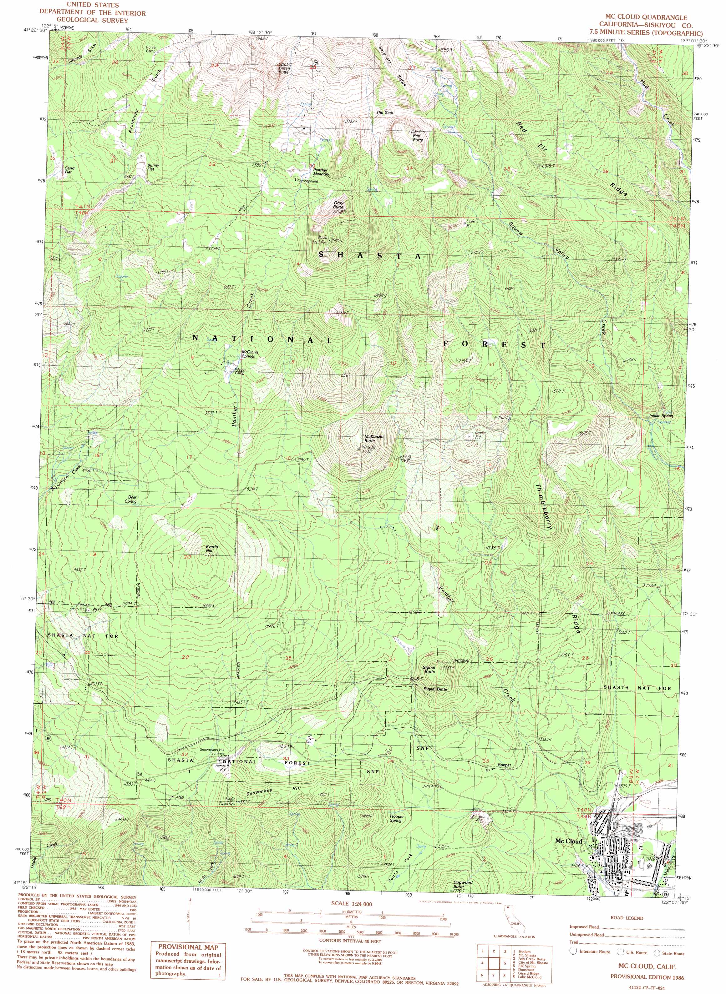
USGS Topo Quad 41122c2 - 1:24,000 scale
| Topo Map Name: | Mccloud |
| USGS Topo Quad ID: | 41122c2 |
| Print Size: | ca. 21 1/4" wide x 27" high |
| Southeast Coordinates: | 41.25° N latitude / 122.125° W longitude |
| Map Center Coordinates: | 41.3125° N latitude / 122.1875° W longitude |
| U.S. State: | CA |
| Filename: | o41122c2.jpg |
| Download Map JPG Image: | Mccloud topo map 1:24,000 scale |
| Map Type: | Topographic |
| Topo Series: | 7.5´ |
| Map Scale: | 1:24,000 |
| Source of Map Images: | United States Geological Survey (USGS) |
| Alternate Map Versions: |
McCloud CA 1986, updated 1986 Download PDF Buy paper map Mc Cloud CA 1998, updated 2003 Download PDF Buy paper map McCloud CA 2012 Download PDF Buy paper map McCloud CA 2015 Download PDF Buy paper map |
| FStopo: | US Forest Service topo McCloud is available: Download FStopo PDF Download FStopo TIF |
1:24,000 Topo Quads surrounding Mccloud
Lake Shastina |
Juniper Flat |
The Whaleback |
West Haight Mountain |
Tennant |
Weed |
Hotlum |
Mount Shasta |
Ash Creek Butte |
Rainbow Mountain |
Mount Eddy |
City Of Mount Shasta |
Mccloud |
Elk Spring |
Kinyon |
Seven Lakes Basin |
Dunsmuir |
Girard Ridge |
Lake Mccloud |
Grizzly Peak |
Chicken Hawk Hill |
Tombstone Mountain |
Yellowjacket Mountain |
Shoeinhorse Mountain |
Big Bend |
> Back to 41122a1 at 1:100,000 scale
> Back to 41122a1 at 1:250,000 scale
> Back to U.S. Topo Maps home
Mccloud topo map: Gazetteer
Mccloud: Flats
Bunny Flat elevation 2125m 6971′Panther Meadow elevation 2276m 7467′
Sand Flat elevation 2054m 6738′
Mccloud: Gaps
Snowmans Hill Summit elevation 1368m 4488′The Gate elevation 2414m 7919′
Mccloud: Populated Places
Hooper elevation 1140m 3740′McCloud elevation 1000m 3280′
Signal Butte elevation 1305m 4281′
Mccloud: Post Offices
McCloud Post Office elevation 996m 3267′Mccloud: Ridges
Red Fir Ridge elevation 2123m 6965′Thimbleberry Ridge elevation 1453m 4767′
Mccloud: Springs
Bear Spring elevation 1550m 5085′Hooper Spring elevation 1207m 3959′
Intake Spring elevation 1404m 4606′
McGinnis Springs elevation 1778m 5833′
Mccloud: Streams
Panther Creek elevation 1021m 3349′Mccloud: Summits
Dogwood Butte elevation 1299m 4261′Everitt Hill elevation 1726m 5662′
Gray Butte elevation 2441m 8008′
Green Butte elevation 2755m 9038′
McKenzie Butte elevation 1841m 6040′
Red Butte elevation 2530m 8300′
Red Hill elevation 2090m 6856′
Signal Butte elevation 1431m 4694′
Snowmans Hill elevation 1468m 4816′
Mccloud: Valleys
Avalanche Gulch elevation 2162m 7093′Mccloud digital topo map on disk
Buy this Mccloud topo map showing relief, roads, GPS coordinates and other geographical features, as a high-resolution digital map file on DVD: