South China Mountain Topo Map California
To zoom in, hover over the map of South China Mountain
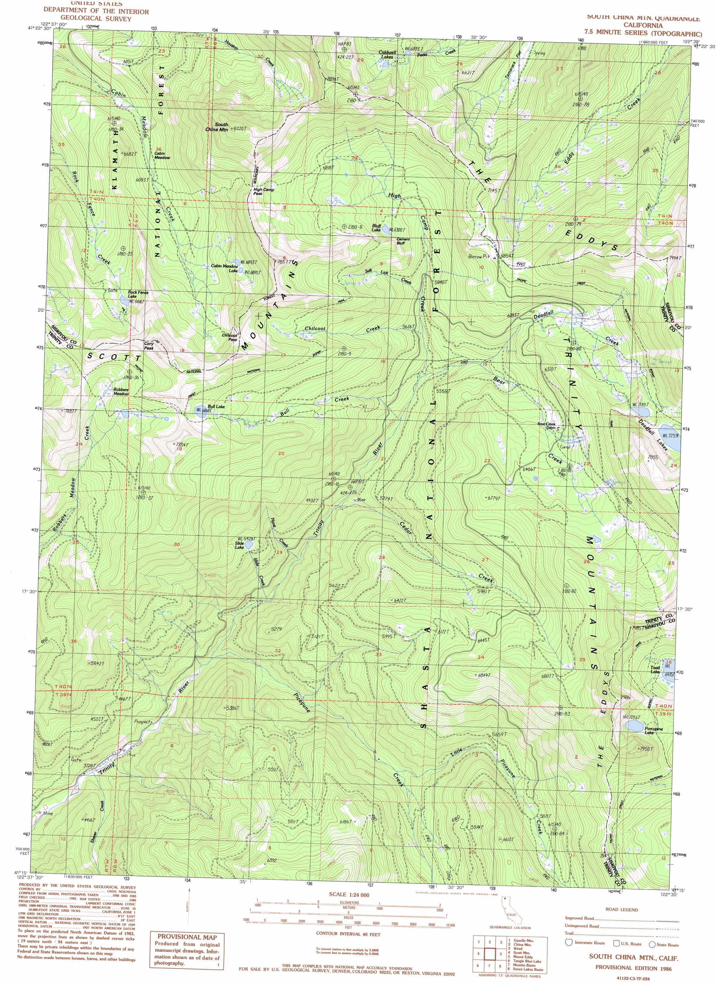
USGS Topo Quad 41122c5 - 1:24,000 scale
| Topo Map Name: | South China Mountain |
| USGS Topo Quad ID: | 41122c5 |
| Print Size: | ca. 21 1/4" wide x 27" high |
| Southeast Coordinates: | 41.25° N latitude / 122.5° W longitude |
| Map Center Coordinates: | 41.3125° N latitude / 122.5625° W longitude |
| U.S. State: | CA |
| Filename: | o41122c5.jpg |
| Download Map JPG Image: | South China Mountain topo map 1:24,000 scale |
| Map Type: | Topographic |
| Topo Series: | 7.5´ |
| Map Scale: | 1:24,000 |
| Source of Map Images: | United States Geological Survey (USGS) |
| Alternate Map Versions: |
South China Mtn. CA 1986, updated 1986 Download PDF Buy paper map South China Mountain CA 1998, updated 2003 Download PDF Buy paper map South China Mountain CA 2012 Download PDF Buy paper map South China Mountain CA 2015 Download PDF Buy paper map |
| FStopo: | US Forest Service topo South China Mountain is available: Download FStopo PDF Download FStopo TIF |
1:24,000 Topo Quads surrounding South China Mountain
Fort Jones |
Duzel Rock |
Gazelle |
Lake Shastina |
Juniper Flat |
Mcconaughy Gulch |
Gazelle Mountain |
China Mountain |
Weed |
Hotlum |
Callahan |
Scott Mountain |
South China Mountain |
Mount Eddy |
City Of Mount Shasta |
Billys Peak |
Tangle Blue Lake |
Mumbo Basin |
Seven Lakes Basin |
Dunsmuir |
Ycatapom Peak |
Carrville |
Whisky Bill Peak |
Chicken Hawk Hill |
Tombstone Mountain |
> Back to 41122a1 at 1:100,000 scale
> Back to 41122a1 at 1:250,000 scale
> Back to U.S. Topo Maps home
South China Mountain topo map: Gazetteer
South China Mountain: Cliffs
Cement Bluff elevation 1828m 5997′South China Mountain: Flats
Cabin Meadow elevation 1842m 6043′Robbers Meadow elevation 2000m 6561′
Tamarack Flat elevation 1829m 6000′
South China Mountain: Gaps
Chilcoot Pass elevation 2195m 7201′High Camp Pass elevation 2245m 7365′
South China Mountain: Lakes
Bluff Lake elevation 1929m 6328′Bull Lake elevation 2095m 6873′
Cabin Meadow Lake elevation 2106m 6909′
Caldwell Lakes elevation 2078m 6817′
Deadfall Lakes elevation 2215m 7267′
Porcupine Lake elevation 2207m 7240′
Rock Fence Lake elevation 2020m 6627′
Slide Lake elevation 1658m 5439′
Toad Lake elevation 2115m 6938′
South China Mountain: Streams
Bear Creek elevation 1626m 5334′Bull Creek elevation 1564m 5131′
Cedar Creek elevation 1447m 4747′
Chilcoot Creek elevation 1693m 5554′
Deadfall Creek elevation 1745m 5725′
High Camp Creek elevation 1701m 5580′
Little Picayune Creek elevation 1499m 4917′
Nyott Creek elevation 1371m 4498′
Picayune Creek elevation 1243m 4078′
Salt Lick Creek elevation 1749m 5738′
Sherer Creek elevation 1135m 3723′
South China Mountain: Summits
Cory Peak elevation 2333m 7654′South China Mountain elevation 2484m 8149′
South China Mountain digital topo map on disk
Buy this South China Mountain topo map showing relief, roads, GPS coordinates and other geographical features, as a high-resolution digital map file on DVD: