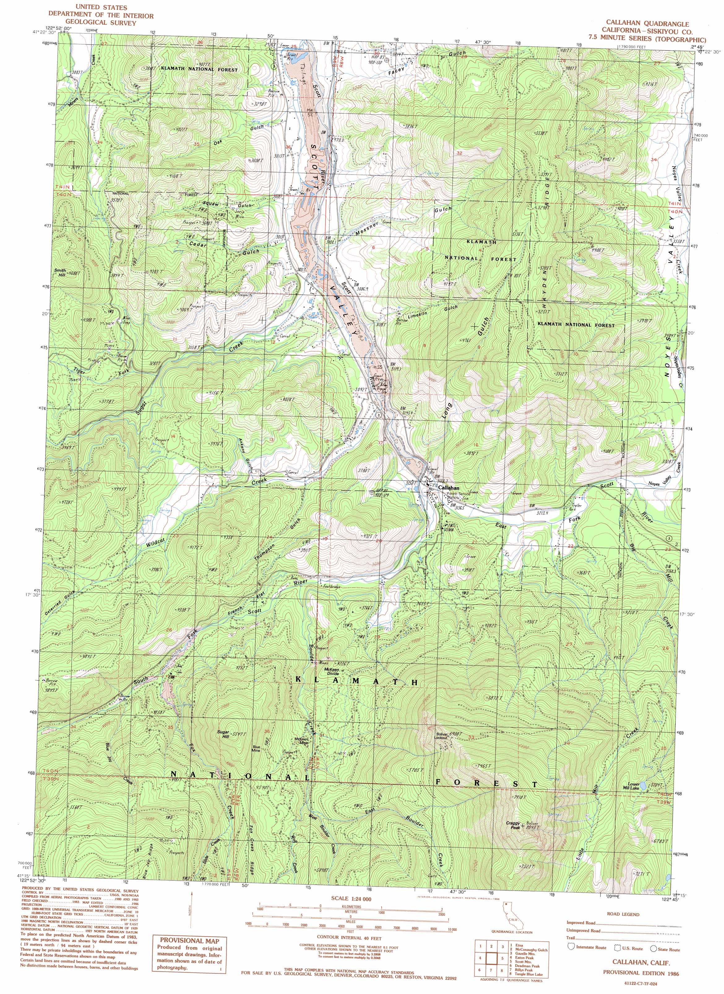
Callahan Topo Map California
To zoom in, hover over the map of Callahan
USGS Topo Quad 41122c7 - 1:24,000 scale
| Topo Map Name: | Callahan |
| USGS Topo Quad ID: | 41122c7 |
| Print Size: | ca. 21 1/4" wide x 27" high |
| Southeast Coordinates: | 41.25° N latitude / 122.75° W longitude |
| Map Center Coordinates: | 41.3125° N latitude / 122.8125° W longitude |
| U.S. State: | CA |
| Filename: | o41122c7.jpg |
| Download Map JPG Image: | Callahan topo map 1:24,000 scale |
| Map Type: | Topographic |
| Topo Series: | 7.5´ |
| Map Scale: | 1:24,000 |
| Source of Map Images: | United States Geological Survey (USGS) |
| Alternate Map Versions: |
Callahan CA 1986, updated 1986 Download PDF Buy paper map Callahan CA 2001, updated 2004 Download PDF Buy paper map Callahan CA 2001, updated 2004 Download PDF Buy paper map Callahan CA 2012 Download PDF Buy paper map Callahan CA 2015 Download PDF Buy paper map |
| FStopo: | US Forest Service topo Callahan is available: Download FStopo PDF Download FStopo TIF |
1:24,000 Topo Quads surrounding Callahan
Boulder Peak |
Greenview |
Fort Jones |
Duzel Rock |
Gazelle |
Yellow Dog Peak |
Etna |
Mcconaughy Gulch |
Gazelle Mountain |
China Mountain |
Tanners Peak |
Eaton Peak |
Callahan |
Scott Mountain |
South China Mountain |
Grasshopper Ridge |
Deadman Peak |
Billys Peak |
Tangle Blue Lake |
Mumbo Basin |
Thompson Peak |
Caribou Lake |
Ycatapom Peak |
Carrville |
Whisky Bill Peak |
> Back to 41122a1 at 1:100,000 scale
> Back to 41122a1 at 1:250,000 scale
> Back to U.S. Topo Maps home
Callahan topo map: Gazetteer
Callahan: Flats
French Flat elevation 1107m 3631′Callahan: Lakes
Lower Mill Lake elevation 1718m 5636′Callahan: Mines
Blue Mine elevation 1456m 4776′Eton Mine elevation 1145m 3756′
McKeen Mine elevation 1226m 4022′
Society Girl Mine elevation 1125m 3690′
Sugar Hill Mine elevation 1380m 4527′
Callahan: Populated Places
Callahan elevation 957m 3139′Rodney's Mobile Park elevation 989m 3244′
Callahan: Post Offices
Callahan Post Office elevation 957m 3139′Callahan: Ridges
Hayden Ridge elevation 1684m 5524′McKeen Divide elevation 1232m 4041′
Callahan: Streams
Big Mill Creek elevation 994m 3261′Blue Jay Creek elevation 1132m 3713′
Boulder Creek elevation 1028m 3372′
East Boulder Creek elevation 1341m 4399′
East Fork Scott River elevation 953m 3126′
Fox Creek elevation 1100m 3608′
Little Mill Creek elevation 1176m 3858′
Noyes Valley Creek elevation 994m 3261′
Slide Creek elevation 1414m 4639′
South Fork Scott River elevation 953m 3126′
Sugar Creek elevation 934m 3064′
Taylor Creek elevation 979m 3211′
Tiger Fork elevation 990m 3248′
West Boulder Creek elevation 1279m 4196′
Wildcat Creek elevation 940m 3083′
Wolf Creek elevation 1274m 4179′
Callahan: Summits
Craggy Peak elevation 2466m 8090′Smith Hill elevation 1414m 4639′
Sugar Hill elevation 1663m 5456′
Callahan: Valleys
Ankeny Gulch elevation 1042m 3418′Cedar Gulch elevation 930m 3051′
Facey Gulch elevation 931m 3054′
Limekiln Gulch elevation 961m 3152′
Long Gulch elevation 986m 3234′
Messner Gulch elevation 960m 3149′
Noyes Valley elevation 1050m 3444′
Oak Gulch elevation 912m 2992′
Osterried Gulch elevation 1152m 3779′
Taritsi Gulch elevation 915m 3001′
Thompson Gulch elevation 983m 3225′
Callahan digital topo map on disk
Buy this Callahan topo map showing relief, roads, GPS coordinates and other geographical features, as a high-resolution digital map file on DVD: