Mount Shasta Topo Map California
To zoom in, hover over the map of Mount Shasta
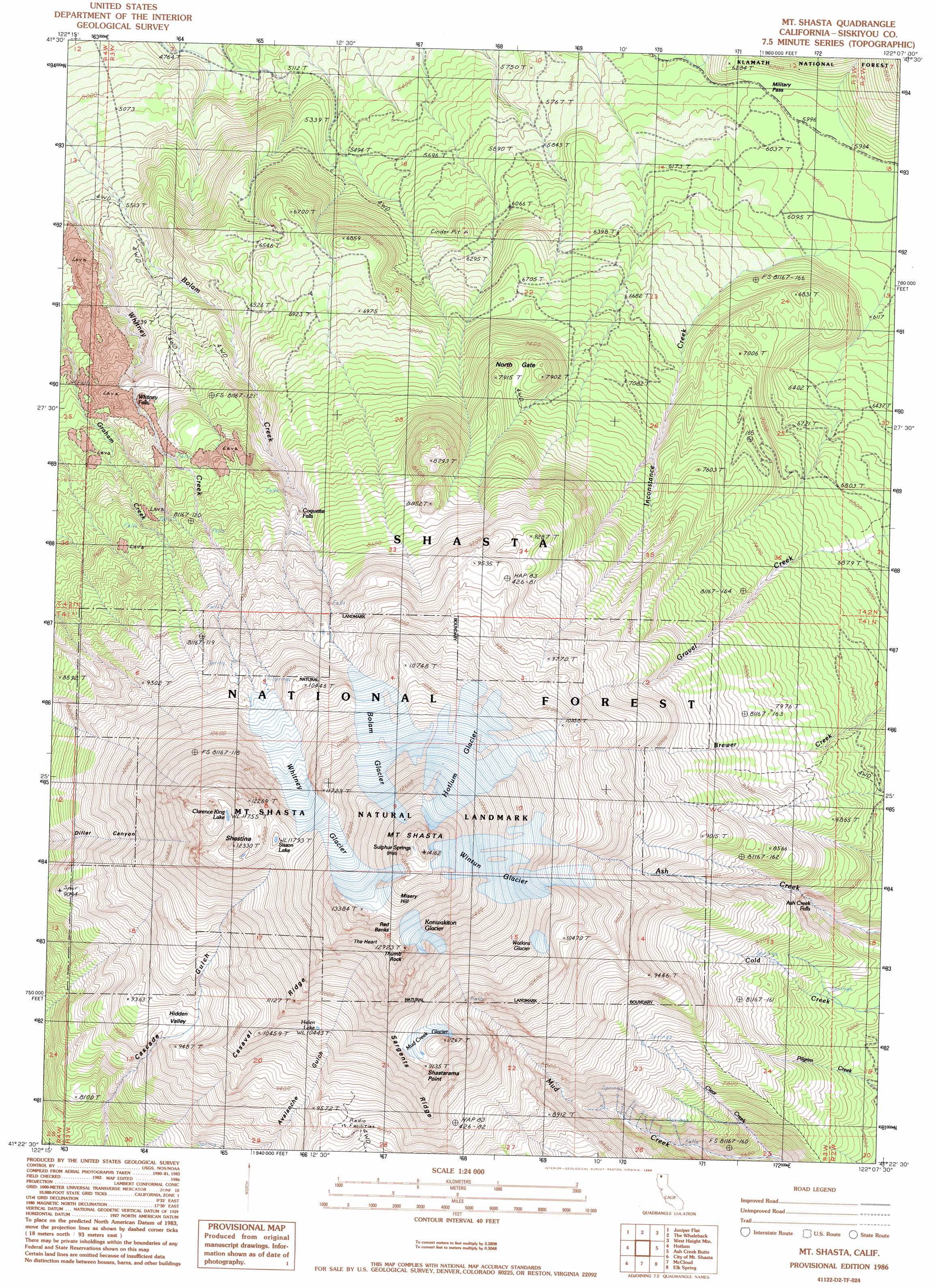
USGS Topo Quad 41122d2 - 1:24,000 scale
| Topo Map Name: | Mount Shasta |
| USGS Topo Quad ID: | 41122d2 |
| Print Size: | ca. 21 1/4" wide x 27" high |
| Southeast Coordinates: | 41.375° N latitude / 122.125° W longitude |
| Map Center Coordinates: | 41.4375° N latitude / 122.1875° W longitude |
| U.S. State: | CA |
| Filename: | o41122d2.jpg |
| Download Map JPG Image: | Mount Shasta topo map 1:24,000 scale |
| Map Type: | Topographic |
| Topo Series: | 7.5´ |
| Map Scale: | 1:24,000 |
| Source of Map Images: | United States Geological Survey (USGS) |
| Alternate Map Versions: |
Mt. Shasta CA 1986, updated 1986 Download PDF Buy paper map Mt. Shasta CA 1998, updated 2003 Download PDF Buy paper map Mount Shasta CA 2012 Download PDF Buy paper map Mount Shasta CA 2015 Download PDF Buy paper map |
| FStopo: | US Forest Service topo Mount Shasta is available: Download FStopo PDF Download FStopo TIF |
1:24,000 Topo Quads surrounding Mount Shasta
Little Shasta |
Solomons Temple |
Grass Lake |
Penoyar |
Bray |
Lake Shastina |
Juniper Flat |
The Whaleback |
West Haight Mountain |
Tennant |
Weed |
Hotlum |
Mount Shasta |
Ash Creek Butte |
Rainbow Mountain |
Mount Eddy |
City Of Mount Shasta |
Mccloud |
Elk Spring |
Kinyon |
Seven Lakes Basin |
Dunsmuir |
Girard Ridge |
Lake Mccloud |
Grizzly Peak |
> Back to 41122a1 at 1:100,000 scale
> Back to 41122a1 at 1:250,000 scale
> Back to U.S. Topo Maps home
Mount Shasta topo map: Gazetteer
Mount Shasta: Areas
The Heart elevation 3786m 12421′Mount Shasta: Basins
Hidden Valley elevation 2839m 9314′Mount Shasta: Falls
Ash Creek Falls elevation 2205m 7234′Coquette Falls elevation 2435m 7988′
Whitney Falls elevation 2025m 6643′
Mount Shasta: Gaps
Military Pass elevation 1830m 6003′North Gate elevation 2395m 7857′
Mount Shasta: Glaciers
Bolam Glacier elevation 3513m 11525′Hotlum Glacier elevation 3623m 11886′
Konwakiton Glacier elevation 3873m 12706′
Mud Creek Glacier elevation 3316m 10879′
Watkins Glacier elevation 3346m 10977′
Whitney Glacier elevation 3469m 11381′
Wintun Glacier elevation 3626m 11896′
Mount Shasta: Lakes
Clarence King Lake elevation 3582m 11751′Helen Lake elevation 3187m 10456′
Sisson Lake elevation 3593m 11788′
Mount Shasta: Parks
Mount Shasta Natural Landmark elevation 3930m 12893′Mount Shasta: Pillars
Thumb Rock elevation 3613m 11853′Mount Shasta: Ridges
Red Banks elevation 3994m 13103′Sargents Ridge elevation 3189m 10462′
Mount Shasta: Springs
Sulphur Springs elevation 4247m 13933′Mount Shasta: Streams
Clear Creek elevation 1966m 6450′Mount Shasta: Summits
Misery Hill elevation 4191m 13750′Mount Shasta elevation 4299m 14104′
Shastarama Point elevation 3384m 11102′
Shastina elevation 3740m 12270′
Mount Shasta digital topo map on disk
Buy this Mount Shasta topo map showing relief, roads, GPS coordinates and other geographical features, as a high-resolution digital map file on DVD: