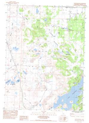
Lake Shastina Topo Map California
To zoom in, hover over the map of Lake Shastina
USGS Topo Quad 41122e4 - 1:24,000 scale
| Topo Map Name: | Lake Shastina |
| USGS Topo Quad ID: | 41122e4 |
| Print Size: | ca. 21 1/4" wide x 27" high |
| Southeast Coordinates: | 41.5° N latitude / 122.375° W longitude |
| Map Center Coordinates: | 41.5625° N latitude / 122.4375° W longitude |
| U.S. State: | CA |
| Filename: | o41122e4.jpg |
| Download Map JPG Image: | Lake Shastina topo map 1:24,000 scale |
| Map Type: | Topographic |
| Topo Series: | 7.5´ |
| Map Scale: | 1:24,000 |
| Source of Map Images: | United States Geological Survey (USGS) |
| Alternate Map Versions: |
Lake Shastina SW CA 1974, updated 1980 Download PDF Buy paper map Lake Shastina CA 1984, updated 1988 Download PDF Buy paper map Lake Shastina CA 2012 Download PDF Buy paper map Lake Shastina CA 2015 Download PDF Buy paper map |
| FStopo: | US Forest Service topo Lake Shastina is available: Download FStopo PDF Download FStopo TIF |
1:24,000 Topo Quads surrounding Lake Shastina
> Back to 41122e1 at 1:100,000 scale
> Back to 41122a1 at 1:250,000 scale
> Back to U.S. Topo Maps home
Lake Shastina topo map: Gazetteer
Lake Shastina: Dams
Shasta River 60-000 Dam elevation 847m 2778′Lake Shastina: Guts
McCloud Slough elevation 803m 2634′Lake Shastina: Lakes
Lost Lake elevation 836m 2742′Lake Shastina: Populated Places
Big Springs elevation 796m 2611′Lake Shastina: Reservoirs
Big Springs Lake elevation 795m 2608′Freeway Lake elevation 829m 2719′
Hole in the Ground Lake elevation 839m 2752′
Lake Shastina elevation 847m 2778′
Lake Shastina: Springs
Hole in the Ground Spring elevation 799m 2621′Little Springs elevation 795m 2608′
Lake Shastina: Streams
Big Springs Creek elevation 781m 2562′Carrick Creek elevation 856m 2808′
Hole in the Ground Creek elevation 791m 2595′
Little Springs Creek elevation 790m 2591′
Parks Creek elevation 791m 2595′
Lake Shastina digital topo map on disk
Buy this Lake Shastina topo map showing relief, roads, GPS coordinates and other geographical features, as a high-resolution digital map file on DVD:


