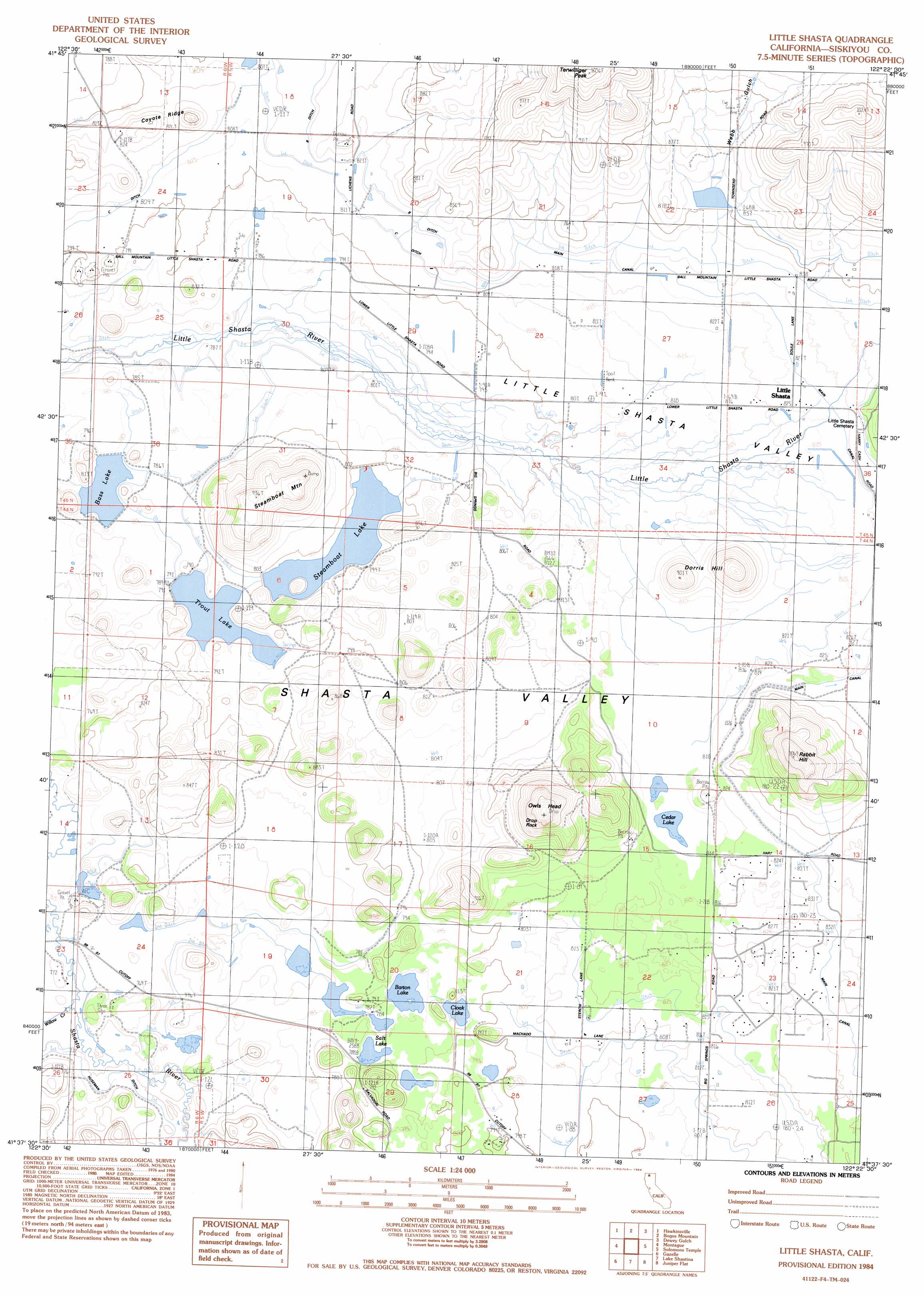
Little Shasta Topo Map California
To zoom in, hover over the map of Little Shasta
USGS Topo Quad 41122f4 - 1:24,000 scale
| Topo Map Name: | Little Shasta |
| USGS Topo Quad ID: | 41122f4 |
| Print Size: | ca. 21 1/4" wide x 27" high |
| Southeast Coordinates: | 41.625° N latitude / 122.375° W longitude |
| Map Center Coordinates: | 41.6875° N latitude / 122.4375° W longitude |
| U.S. State: | CA |
| Filename: | o41122f4.jpg |
| Download Map JPG Image: | Little Shasta topo map 1:24,000 scale |
| Map Type: | Topographic |
| Topo Series: | 7.5´ |
| Map Scale: | 1:24,000 |
| Source of Map Images: | United States Geological Survey (USGS) |
| Alternate Map Versions: |
Little Shasta CA 1984, updated 1984 Download PDF Buy paper map Little Shasta CA 2012 Download PDF Buy paper map Little Shasta CA 2015 Download PDF Buy paper map |
| FStopo: | US Forest Service topo Little Shasta is available: Download FStopo PDF Download FStopo TIF |
1:24,000 Topo Quads surrounding Little Shasta
Cottonwood Peak |
Hornbrook |
Iron Gate Reservoir |
Copco |
Secret Spring Mountain |
Badger Mountain |
Hawkinsville |
Bogus Mountain |
Dewey Gulch |
Panther Rock |
Yreka |
Montague |
Little Shasta |
Solomons Temple |
Grass Lake |
Duzel Rock |
Gazelle |
Lake Shastina |
Juniper Flat |
The Whaleback |
Gazelle Mountain |
China Mountain |
Weed |
Hotlum |
Mount Shasta |
> Back to 41122e1 at 1:100,000 scale
> Back to 41122a1 at 1:250,000 scale
> Back to U.S. Topo Maps home
Little Shasta topo map: Gazetteer
Little Shasta: Dams
Barton 1181-002 Dam elevation 788m 2585′Cloak Lake 1181 Dam elevation 790m 2591′
Earl B Fiock 187 Dam elevation 786m 2578′
Earl B Fiock Number 2 2180 Dam elevation 798m 2618′
Earl B Fiock Number 3 2180-002 Dam elevation 788m 2585′
Shelley 1180 Dam elevation 849m 2785′
Little Shasta: Lakes
Cedar Lake elevation 812m 2664′Cloak Lake elevation 790m 2591′
Salt Lake elevation 790m 2591′
Little Shasta: Parks
Lava Lakes Wildlife Sanctuary elevation 853m 2798′Little Shasta: Populated Places
Little Shasta elevation 824m 2703′Little Shasta: Reservoirs
Barton Lake elevation 790m 2591′Bass Lake elevation 782m 2565′
Steamboat Lake elevation 798m 2618′
Trout Lake elevation 791m 2595′
Little Shasta: Ridges
Coyote Ridge elevation 848m 2782′Little Shasta: Summits
Dorris Hill elevation 891m 2923′Drop Rock elevation 1029m 3375′
Owls Head elevation 1010m 3313′
Rabbit Hill elevation 976m 3202′
Steamboat Mountain elevation 931m 3054′
Terwilliger Peak elevation 1029m 3375′
Little Shasta: Valleys
Webb Gulch elevation 864m 2834′Little Shasta digital topo map on disk
Buy this Little Shasta topo map showing relief, roads, GPS coordinates and other geographical features, as a high-resolution digital map file on DVD: