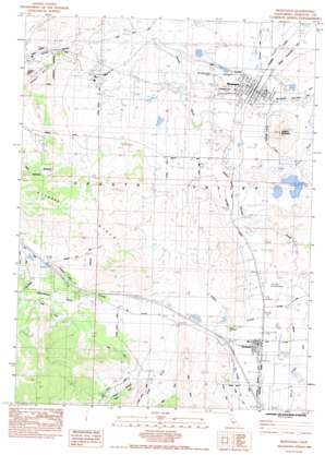
Montague Topo Map California
To zoom in, hover over the map of Montague
USGS Topo Quad 41122f5 - 1:24,000 scale
| Topo Map Name: | Montague |
| USGS Topo Quad ID: | 41122f5 |
| Print Size: | ca. 21 1/4" wide x 27" high |
| Southeast Coordinates: | 41.625° N latitude / 122.5° W longitude |
| Map Center Coordinates: | 41.6875° N latitude / 122.5625° W longitude |
| U.S. State: | CA |
| Filename: | o41122f5.jpg |
| Download Map JPG Image: | Montague topo map 1:24,000 scale |
| Map Type: | Topographic |
| Topo Series: | 7.5´ |
| Map Scale: | 1:24,000 |
| Source of Map Images: | United States Geological Survey (USGS) |
| Alternate Map Versions: |
Montague CA 1984, updated 1984 Download PDF Buy paper map Montague CA 1984, updated 1986 Download PDF Buy paper map Montague CA 2012 Download PDF Buy paper map Montague CA 2015 Download PDF Buy paper map |
| FStopo: | US Forest Service topo Montague is available: Download FStopo PDF Download FStopo TIF |
1:24,000 Topo Quads surrounding Montague
> Back to 41122e1 at 1:100,000 scale
> Back to 41122a1 at 1:250,000 scale
> Back to U.S. Topo Maps home
Montague topo map: Gazetteer
Montague: Airports
Montague-Yreka Rohrer Field elevation 767m 2516′Montague: Dams
Fiock Number 2 2181 Dam elevation 772m 2532′George Fiock Number 1 189 Dam elevation 769m 2522′
Montague Number 2 2012 Dam elevation 775m 2542′
Pruett 184 Dam elevation 877m 2877′
Montague: Populated Places
Cascade Sun Mobile Home Estates elevation 774m 2539′Cove Mobile Villa elevation 853m 2798′
Grenada elevation 782m 2565′
Horizon Hills Mobile Home Park elevation 771m 2529′
Montague elevation 774m 2539′
Montague: Post Offices
Grenada Post Office elevation 785m 2575′Montague Post Office elevation 774m 2539′
Montague: Ranges
Kilgore Hills elevation 1101m 3612′Montague: Streams
Julien Creek elevation 764m 2506′Little Shasta River elevation 753m 2470′
Oregon Slu elevation 738m 2421′
Willow Creek elevation 771m 2529′
Montague: Summits
Butcher Hill elevation 962m 3156′Gregory Mountain elevation 998m 3274′
Montague: Valleys
Cram Gulch elevation 847m 2778′Guys Gulch elevation 858m 2814′
Schulmeyer Gulch elevation 891m 2923′
Montague digital topo map on disk
Buy this Montague topo map showing relief, roads, GPS coordinates and other geographical features, as a high-resolution digital map file on DVD:


