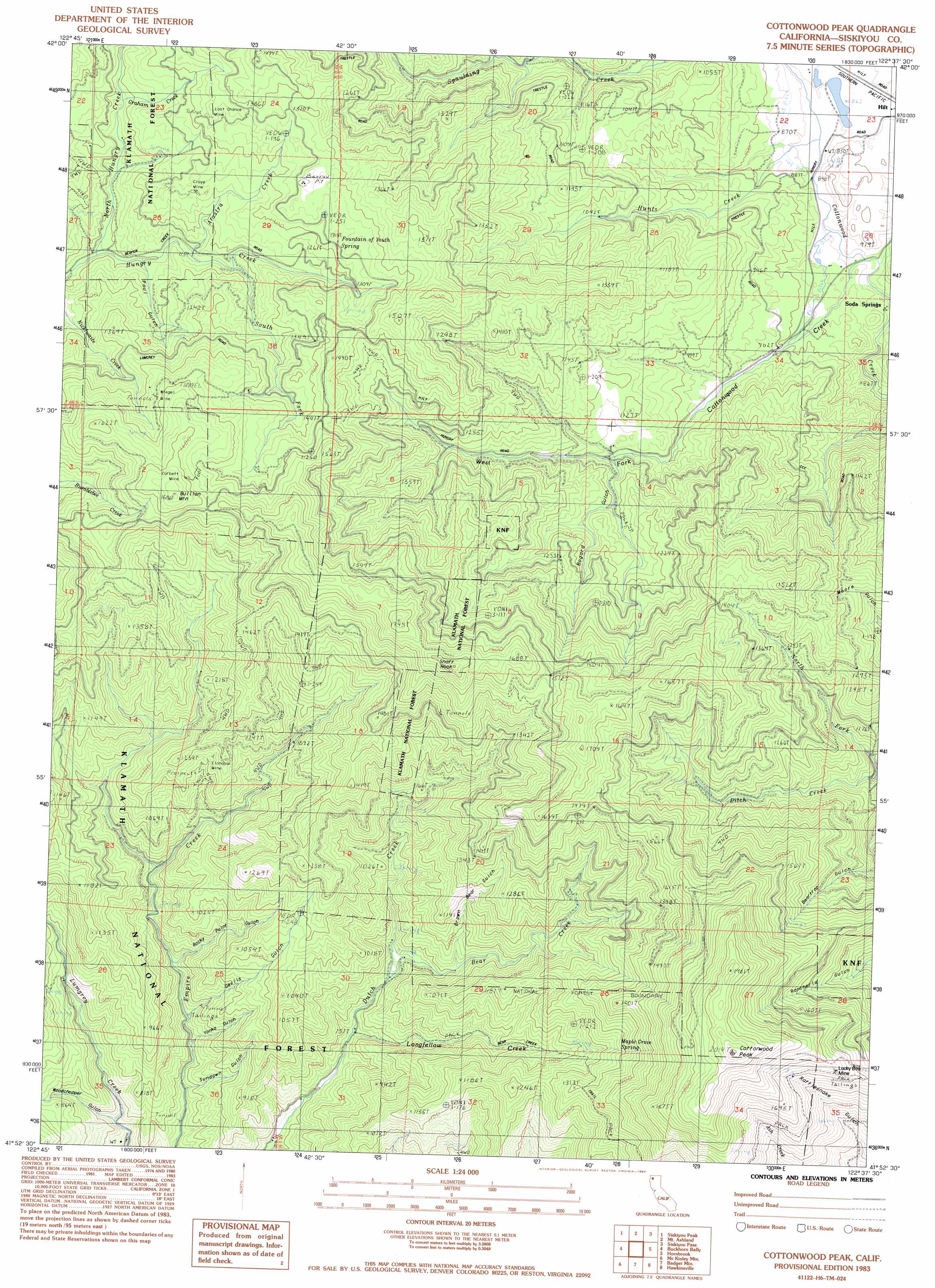
Cottonwood Peak Topo Map California
To zoom in, hover over the map of Cottonwood Peak
USGS Topo Quad 41122h6 - 1:24,000 scale
| Topo Map Name: | Cottonwood Peak |
| USGS Topo Quad ID: | 41122h6 |
| Print Size: | ca. 21 1/4" wide x 27" high |
| Southeast Coordinates: | 41.875° N latitude / 122.625° W longitude |
| Map Center Coordinates: | 41.9375° N latitude / 122.6875° W longitude |
| U.S. State: | CA |
| Filename: | o41122h6.jpg |
| Download Map JPG Image: | Cottonwood Peak topo map 1:24,000 scale |
| Map Type: | Topographic |
| Topo Series: | 7.5´ |
| Map Scale: | 1:24,000 |
| Source of Map Images: | United States Geological Survey (USGS) |
| Alternate Map Versions: |
Cottonwood Peak CA 1983, updated 1984 Download PDF Buy paper map Cottonwood Peak CA 2001, updated 2004 Download PDF Buy paper map Cottonwood Peak CA 2012 Download PDF Buy paper map Cottonwood Peak CA 2015 Download PDF Buy paper map |
| FStopo: | US Forest Service topo Cottonwood Peak is available: Download FStopo PDF Download FStopo TIF |
1:24,000 Topo Quads surrounding Cottonwood Peak
Sterling Creek |
Talent |
Ashland |
Emigrant Lake |
Hyatt Reservoir |
Dutchman Peak |
Siskiyou Peak |
Mount Ashland |
Siskiyou Pass |
Soda Mountain |
Condrey Mountain |
Buckhorn Bally |
Cottonwood Peak |
Hornbrook |
Iron Gate Reservoir |
Horse Creek |
Mckinley Mountain |
Badger Mountain |
Hawkinsville |
Bogus Mountain |
Russell Peak |
Indian Creek Baldy |
Yreka |
Montague |
Little Shasta |
> Back to 41122e1 at 1:100,000 scale
> Back to 41122a1 at 1:250,000 scale
> Back to U.S. Topo Maps home
Cottonwood Peak topo map: Gazetteer
Cottonwood Peak: Mines
Bluejay Mine elevation 1252m 4107′Bumblebee Mine elevation 1566m 5137′
Cinnabar Mine elevation 1124m 3687′
Clay Mine elevation 1247m 4091′
Corbett Mine elevation 1573m 5160′
Last Chance Mine elevation 1309m 4294′
Lucky Boy Mine elevation 1571m 5154′
New Year Mine elevation 1382m 4534′
Sterling Mine elevation 1221m 4005′
Wiegel Mine elevation 1501m 4924′
Cottonwood Peak: Pillars
Shaft Rock elevation 1738m 5702′Cottonwood Peak: Springs
Fountain of Youth Spring elevation 1335m 4379′Maple Grove Spring elevation 1469m 4819′
Soda Spring elevation 837m 2746′
Cottonwood Peak: Streams
Arastra Creek elevation 1137m 3730′Bear Creek elevation 829m 2719′
Graham Creek elevation 1174m 3851′
Hunts Creek elevation 860m 2821′
Longfellow Creek elevation 752m 2467′
North Fork Ditch Creek elevation 981m 3218′
North Hungry Creek elevation 1081m 3546′
West Cottonwood Creek elevation 831m 2726′
Cottonwood Peak: Summits
Bullion Mountain elevation 1668m 5472′Cottonwood Peak elevation 1995m 6545′
Cottonwood Peak: Trails
Bear Creek Trail elevation 1075m 3526′Copper Trail elevation 1148m 3766′
Cottonwood Peak: Valleys
Bogard Gulch elevation 1057m 3467′Devils Gulch elevation 754m 2473′
Paul Gulch elevation 1125m 3690′
Rocky Point Gulch elevation 776m 2545′
Sundown Gulch elevation 675m 2214′
Woodchopper Gulch elevation 657m 2155′
Yonka Gulch elevation 715m 2345′
Cottonwood Peak digital topo map on disk
Buy this Cottonwood Peak topo map showing relief, roads, GPS coordinates and other geographical features, as a high-resolution digital map file on DVD: