Weitchpec Topo Map California
To zoom in, hover over the map of Weitchpec
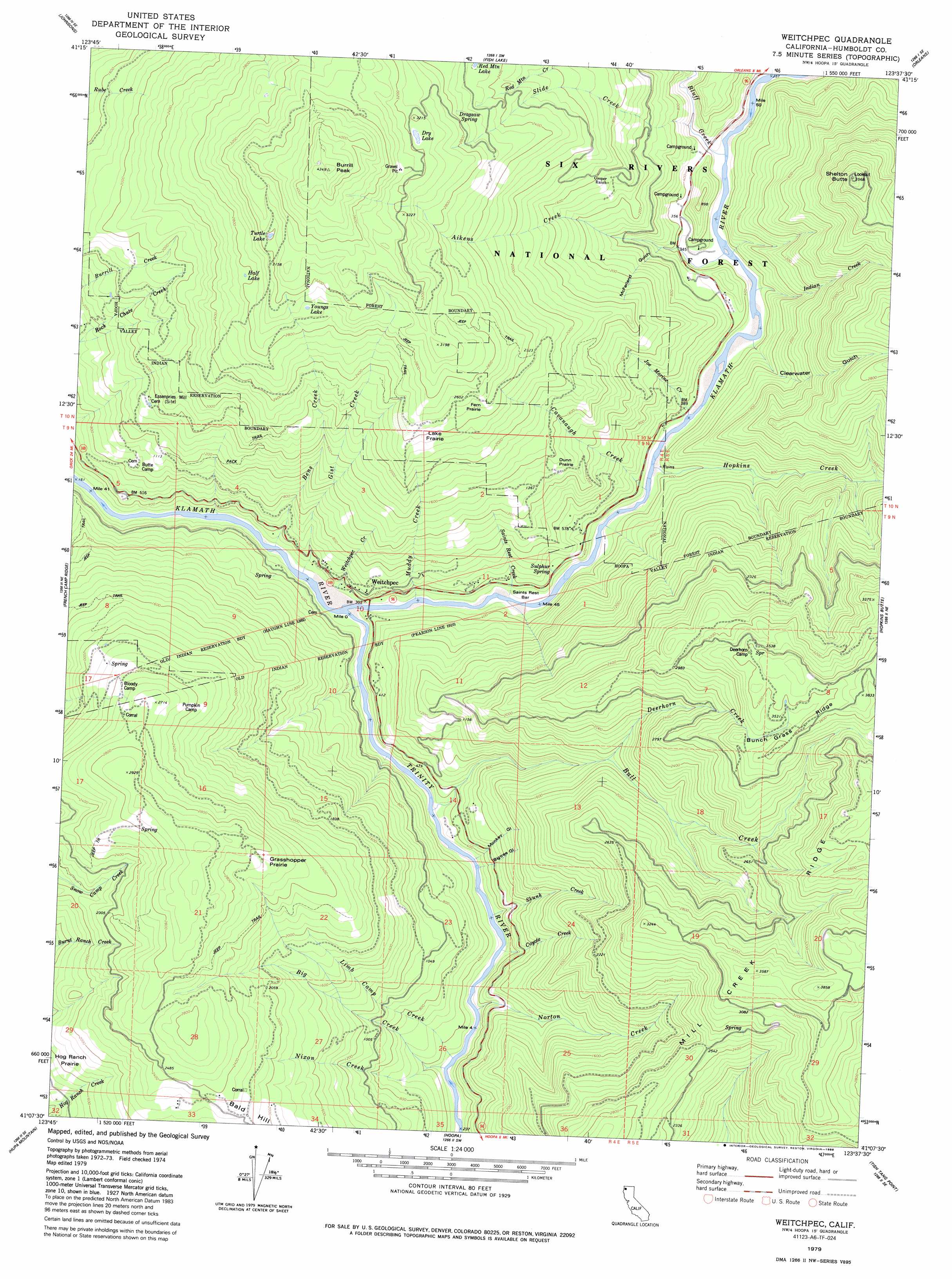
USGS Topo Quad 41123b6 - 1:24,000 scale
| Topo Map Name: | Weitchpec |
| USGS Topo Quad ID: | 41123b6 |
| Print Size: | ca. 21 1/4" wide x 27" high |
| Southeast Coordinates: | 41.125° N latitude / 123.625° W longitude |
| Map Center Coordinates: | 41.1875° N latitude / 123.6875° W longitude |
| U.S. State: | CA |
| Filename: | o41123b6.jpg |
| Download Map JPG Image: | Weitchpec topo map 1:24,000 scale |
| Map Type: | Topographic |
| Topo Series: | 7.5´ |
| Map Scale: | 1:24,000 |
| Source of Map Images: | United States Geological Survey (USGS) |
| Alternate Map Versions: |
Weitchpec CA 1979, updated 1988 Download PDF Buy paper map Weitchpec CA 1997, updated 2001 Download PDF Buy paper map Weitchpec CA 2012 Download PDF Buy paper map Weitchpec CA 2015 Download PDF Buy paper map |
| FStopo: | US Forest Service topo Weitchpec is available: Download FStopo PDF Download FStopo TIF |
1:24,000 Topo Quads surrounding Weitchpec
Ah Pah Ridge |
Blue Creek Mountain |
Lonesome Ridge |
Bark Shanty Gulch |
Somes Bar |
Holter Ridge |
Johnsons |
Fish Lake |
Orleans |
Orleans Mountain |
Bald Hills |
French Camp Ridge |
Weitchpec |
Hopkins Butte |
Salmon Mountain |
Panther Creek |
Hupa Mountain |
Hoopa |
Tish Tang Point |
Trinity Mountain |
Blue Lake |
Lord-Ellis Summit |
Willow Creek |
Salyer |
Denny |
> Back to 41123a1 at 1:100,000 scale
> Back to 41122a1 at 1:250,000 scale
> Back to U.S. Topo Maps home
Weitchpec topo map: Gazetteer
Weitchpec: Areas
Dunn Prairie elevation 456m 1496′Fern Prairie elevation 754m 2473′
Grasshopper Prairie elevation 832m 2729′
Lake Prairir elevation 732m 2401′
Weitchpec: Bars
Saints Rest Bar elevation 73m 239′Weitchpec: Lakes
Dry Lake elevation 976m 3202′Half Lake elevation 836m 2742′
Turtle Lake elevation 977m 3205′
Youngs Lake elevation 923m 3028′
Weitchpec: Populated Places
Ertlerger (historical) elevation 66m 216′Pekwuteu (historical) elevation 106m 347′
Weitchpec elevation 110m 360′
Weitchpec: Ridges
Bunch Grass Ridge elevation 1104m 3622′Mill Creek Ridge elevation 811m 2660′
Weitchpec: Springs
Dragsaw Spring elevation 866m 2841′Sulphur Spring elevation 145m 475′
Weitchpec: Streams
Aikens Creek elevation 79m 259′Bens Creek elevation 63m 206′
Big Creek elevation 73m 239′
Bluff Creek elevation 84m 275′
Bull Creek elevation 64m 209′
Cacanaugh Creek elevation 78m 255′
Coyote Creek elevation 68m 223′
Deerhorn Creek elevation 446m 1463′
Gist Creek elevation 56m 183′
Hopkins Creek elevation 79m 259′
Indian Creek elevation 77m 252′
Joe Marine Creek elevation 97m 318′
Limb Camp Creek elevation 72m 236′
Muddy Creek elevation 76m 249′
Nixon Creek elevation 72m 236′
Norton Creek elevation 70m 229′
Red Mountain Creek elevation 214m 702′
Saints Rest Creek elevation 67m 219′
Skunk Creek elevation 87m 285′
Slide Creek elevation 146m 479′
Trinity River elevation 59m 193′
Weitchpec Creek elevation 73m 239′
Weitchpec: Summits
Burrill Peak elevation 1287m 4222′Shelton Butte elevation 1080m 3543′
Weitchpec: Valleys
Bigtree Gulch elevation 86m 282′Clearwater Gulch elevation 96m 314′
McFarland Gulch elevation 190m 623′
Monkey Gulch elevation 83m 272′
Weitchpec digital topo map on disk
Buy this Weitchpec topo map showing relief, roads, GPS coordinates and other geographical features, as a high-resolution digital map file on DVD: