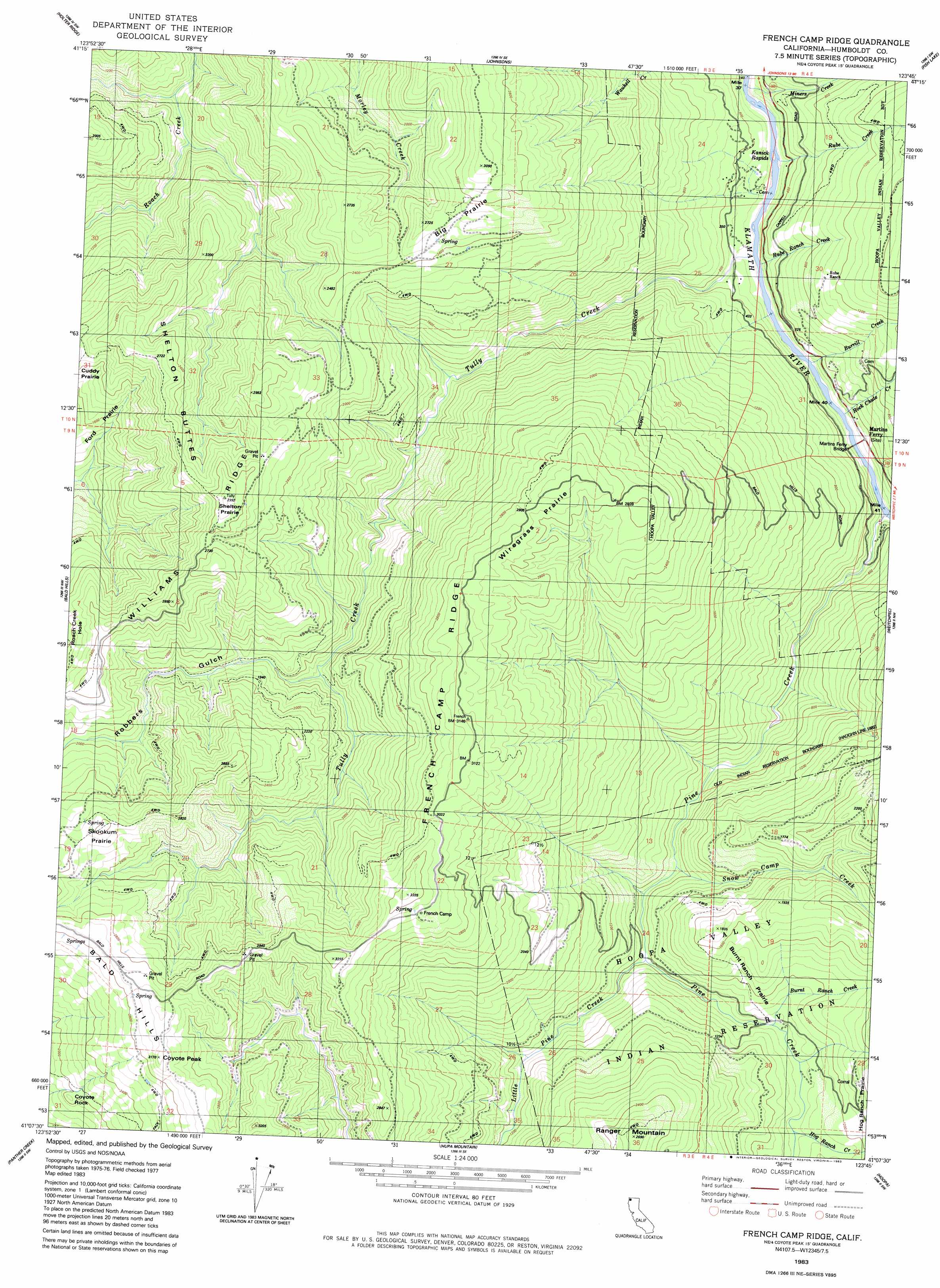
French Camp Ridge Topo Map California
To zoom in, hover over the map of French Camp Ridge
USGS Topo Quad 41123b7 - 1:24,000 scale
| Topo Map Name: | French Camp Ridge |
| USGS Topo Quad ID: | 41123b7 |
| Print Size: | ca. 21 1/4" wide x 27" high |
| Southeast Coordinates: | 41.125° N latitude / 123.75° W longitude |
| Map Center Coordinates: | 41.1875° N latitude / 123.8125° W longitude |
| U.S. State: | CA |
| Filename: | o41123b7.jpg |
| Download Map JPG Image: | French Camp Ridge topo map 1:24,000 scale |
| Map Type: | Topographic |
| Topo Series: | 7.5´ |
| Map Scale: | 1:24,000 |
| Source of Map Images: | United States Geological Survey (USGS) |
| Alternate Map Versions: |
French Camp Ridge CA 1983, updated 1983 Download PDF Buy paper map French Camp Ridge CA 1983, updated 1983 Download PDF Buy paper map French Camp Ridge CA 2012 Download PDF Buy paper map French Camp Ridge CA 2015 Download PDF Buy paper map |
1:24,000 Topo Quads surrounding French Camp Ridge
Fern Canyon |
Ah Pah Ridge |
Blue Creek Mountain |
Lonesome Ridge |
Bark Shanty Gulch |
Orick |
Holter Ridge |
Johnsons |
Fish Lake |
Orleans |
Rodgers Peak |
Bald Hills |
French Camp Ridge |
Weitchpec |
Hopkins Butte |
Crannell |
Panther Creek |
Hupa Mountain |
Hoopa |
Tish Tang Point |
Arcata North |
Blue Lake |
Lord-Ellis Summit |
Willow Creek |
Salyer |
> Back to 41123a1 at 1:100,000 scale
> Back to 41122a1 at 1:250,000 scale
> Back to U.S. Topo Maps home
French Camp Ridge topo map: Gazetteer
French Camp Ridge: Areas
Big Prairie elevation 813m 2667′Ford Prairie elevation 459m 1505′
Hog Ranch Prairie elevation 508m 1666′
Shelton Prairie elevation 865m 2837′
Skookum Prairie elevation 827m 2713′
Wiregrass Prairie elevation 884m 2900′
French Camp Ridge: Bridges
Martins Ferry Bridge elevation 44m 144′French Camp Ridge: Flats
Burnt Ranch Prairie elevation 321m 1053′French Camp Ridge: Pillars
Coyote Rock elevation 614m 2014′French Camp Ridge: Populated Places
Martins Ferry (historical) elevation 96m 314′Waseck elevation 259m 849′
French Camp Ridge: Ranges
Shelton Buttes elevation 808m 2650′French Camp Ridge: Rapids
Kanick Rapids elevation 38m 124′French Camp Ridge: Ridges
French Camp Ridge elevation 943m 3093′Williams Ridge elevation 805m 2641′
French Camp Ridge: Streams
Burnt Ranch Creek elevation 271m 889′Burrill Creek elevation 105m 344′
Hog Ranch Creek elevation 301m 987′
Little Pine Creek elevation 228m 748′
Miners Creek elevation 54m 177′
Pine Creek elevation 73m 239′
Rock Chute Creek elevation 49m 160′
Rube Creek elevation 78m 255′
Rube Ranch Creek elevation 43m 141′
Snow Camp Creek elevation 234m 767′
Tully Creek elevation 39m 127′
French Camp Ridge: Summits
Coyote Peak elevation 951m 3120′Ranger Mountain elevation 812m 2664′
French Camp Ridge: Valleys
Robbers Gulch elevation 438m 1437′French Camp Ridge digital topo map on disk
Buy this French Camp Ridge topo map showing relief, roads, GPS coordinates and other geographical features, as a high-resolution digital map file on DVD: