Orleans Mountain Topo Map California
To zoom in, hover over the map of Orleans Mountain
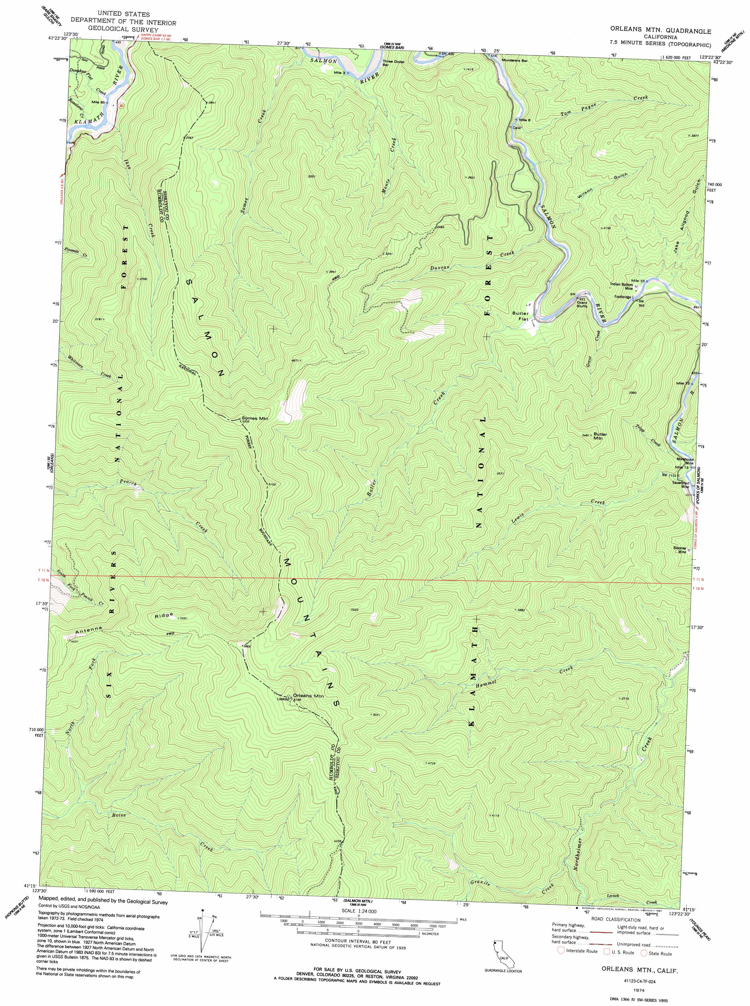
USGS Topo Quad 41123c4 - 1:24,000 scale
| Topo Map Name: | Orleans Mountain |
| USGS Topo Quad ID: | 41123c4 |
| Print Size: | ca. 21 1/4" wide x 27" high |
| Southeast Coordinates: | 41.25° N latitude / 123.375° W longitude |
| Map Center Coordinates: | 41.3125° N latitude / 123.4375° W longitude |
| U.S. State: | CA |
| Filename: | o41123c4.jpg |
| Download Map JPG Image: | Orleans Mountain topo map 1:24,000 scale |
| Map Type: | Topographic |
| Topo Series: | 7.5´ |
| Map Scale: | 1:24,000 |
| Source of Map Images: | United States Geological Survey (USGS) |
| Alternate Map Versions: |
Orleans Mtn. CA 1974, updated 1977 Download PDF Buy paper map Orleans Mtn. CA 1974, updated 1991 Download PDF Buy paper map Orleans Mountain CA 2001, updated 2004 Download PDF Buy paper map Orleans Mountain CA 2012 Download PDF Buy paper map Orleans Mountain CA 2015 Download PDF Buy paper map |
| FStopo: | US Forest Service topo Orleans Mountain is available: Download FStopo PDF Download FStopo TIF |
1:24,000 Topo Quads surrounding Orleans Mountain
Chimney Rock |
Dillon Mountain |
Ukonom Mountain |
Ukonom Lake |
Marble Mountain |
Lonesome Ridge |
Bark Shanty Gulch |
Somes Bar |
Medicine Mountain |
English Peak |
Fish Lake |
Orleans |
Orleans Mountain |
Forks Of Salmon |
Sawyers Bar |
Weitchpec |
Hopkins Butte |
Salmon Mountain |
Youngs Peak |
Cecilville |
Hoopa |
Tish Tang Point |
Trinity Mountain |
Dees Peak |
Cecil Lake |
> Back to 41123a1 at 1:100,000 scale
> Back to 41122a1 at 1:250,000 scale
> Back to U.S. Topo Maps home
Orleans Mountain topo map: Gazetteer
Orleans Mountain: Bars
Three Dollar Bar elevation 171m 561′Orleans Mountain: Cliffs
Grant Bluffs elevation 243m 797′Orleans Mountain: Flats
Butler Flat elevation 258m 846′Orleans Mountain: Mines
Bloomer Mine elevation 405m 1328′Indian Bottom Mine elevation 281m 921′
Morehouse Mine elevation 313m 1026′
Orleans Mountain: Ridges
Antenna Ridge elevation 1380m 4527′Orleans Mountain: Streams
Butler Creek elevation 250m 820′Donahue Flat Creek elevation 144m 472′
Duncan Creek elevation 233m 764′
Granite Creek elevation 538m 1765′
Grant Creek elevation 273m 895′
Hammel Creek elevation 390m 1279′
Ikes Creek elevation 142m 465′
Lewis Creek elevation 303m 994′
Monte Creek elevation 178m 583′
Morehouse Creek elevation 305m 1000′
North Fork Boise Creek elevation 508m 1666′
Rosaleno Creek elevation 144m 472′
Somes Creek elevation 209m 685′
Tom Payne Creek elevation 219m 718′
Tripp Creek elevation 302m 990′
Orleans Mountain: Summits
Butler Mountain elevation 1050m 3444′Orleans Mountain elevation 1874m 6148′
Somes Mountain elevation 1599m 5246′
Orleans Mountain: Valleys
Jake Allgood Gulch elevation 344m 1128′Wilson Gulch elevation 213m 698′
Orleans Mountain digital topo map on disk
Buy this Orleans Mountain topo map showing relief, roads, GPS coordinates and other geographical features, as a high-resolution digital map file on DVD: