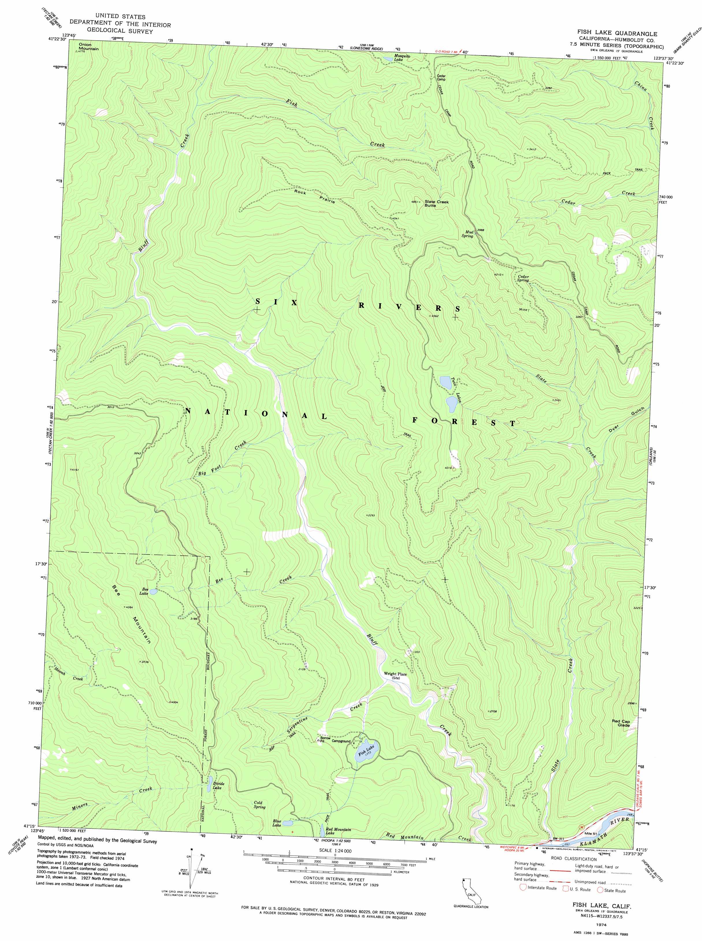
Fish Lake Topo Map California
To zoom in, hover over the map of Fish Lake
USGS Topo Quad 41123c6 - 1:24,000 scale
| Topo Map Name: | Fish Lake |
| USGS Topo Quad ID: | 41123c6 |
| Print Size: | ca. 21 1/4" wide x 27" high |
| Southeast Coordinates: | 41.25° N latitude / 123.625° W longitude |
| Map Center Coordinates: | 41.3125° N latitude / 123.6875° W longitude |
| U.S. State: | CA |
| Filename: | o41123c6.jpg |
| Download Map JPG Image: | Fish Lake topo map 1:24,000 scale |
| Map Type: | Topographic |
| Topo Series: | 7.5´ |
| Map Scale: | 1:24,000 |
| Source of Map Images: | United States Geological Survey (USGS) |
| Alternate Map Versions: |
Fish Lake CA 1974, updated 1977 Download PDF Buy paper map Fish Lake CA 1997, updated 2001 Download PDF Buy paper map Fish Lake CA 2012 Download PDF Buy paper map Fish Lake CA 2015 Download PDF Buy paper map |
| FStopo: | US Forest Service topo Fish Lake is available: Download FStopo PDF Download FStopo TIF |
1:24,000 Topo Quads surrounding Fish Lake
Klamath Glen |
Summit Valley |
Chimney Rock |
Dillon Mountain |
Ukonom Mountain |
Ah Pah Ridge |
Blue Creek Mountain |
Lonesome Ridge |
Bark Shanty Gulch |
Somes Bar |
Holter Ridge |
Johnsons |
Fish Lake |
Orleans |
Orleans Mountain |
Bald Hills |
French Camp Ridge |
Weitchpec |
Hopkins Butte |
Salmon Mountain |
Panther Creek |
Hupa Mountain |
Hoopa |
Tish Tang Point |
Trinity Mountain |
> Back to 41123a1 at 1:100,000 scale
> Back to 41122a1 at 1:250,000 scale
> Back to U.S. Topo Maps home
Fish Lake topo map: Gazetteer
Fish Lake: Areas
Rock Prairie elevation 1217m 3992′Fish Lake: Flats
Red Cap Glade elevation 763m 2503′Fish Lake: Lakes
Bee Lake elevation 1084m 3556′Blue Lake elevation 822m 2696′
Divide Lake elevation 951m 3120′
Fish Lake elevation 541m 1774′
Mosquito Lake elevation 1240m 4068′
Red Mountain Lake elevation 770m 2526′
Twin Lakes elevation 1143m 3750′
Fish Lake: Populated Places
Wright Place elevation 296m 971′Fish Lake: Springs
Cedar Spring elevation 1093m 3585′Cold Spring elevation 944m 3097′
Mud Spring elevation 1240m 4068′
Fish Lake: Streams
Bee Creek elevation 324m 1062′Big Foot Creek elevation 386m 1266′
Fish Creek elevation 555m 1820′
Serpentine Creek elevation 276m 905′
Slate Creek elevation 83m 272′
Fish Lake: Summits
Bee Mountain elevation 1325m 4347′Onion Mountain elevation 1443m 4734′
Slate Creek Butte elevation 1475m 4839′
Fish Lake: Valleys
Dyer Gulch elevation 380m 1246′Fish Lake digital topo map on disk
Buy this Fish Lake topo map showing relief, roads, GPS coordinates and other geographical features, as a high-resolution digital map file on DVD: