Klamath Glen Topo Map California
To zoom in, hover over the map of Klamath Glen
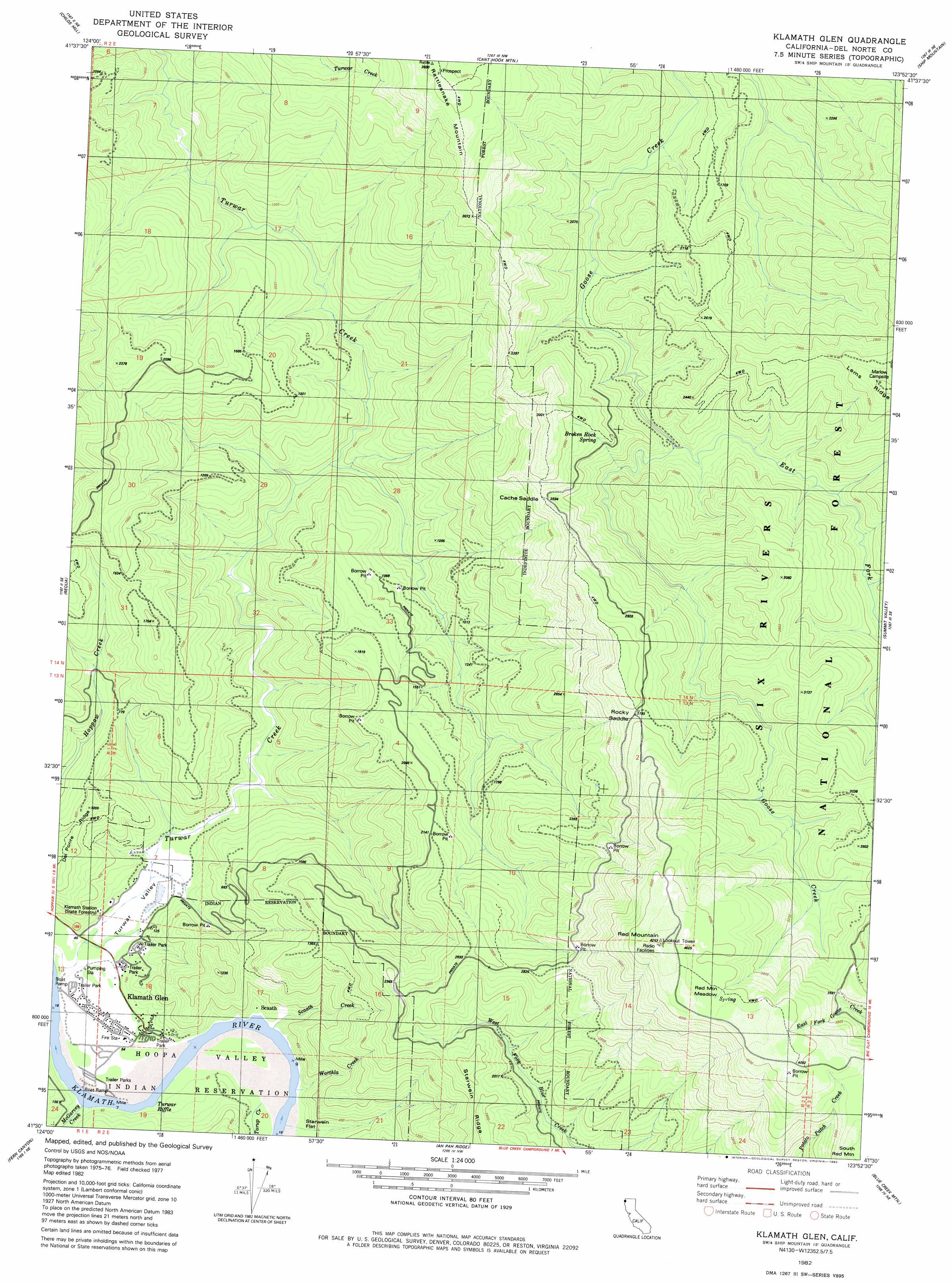
USGS Topo Quad 41123e8 - 1:24,000 scale
| Topo Map Name: | Klamath Glen |
| USGS Topo Quad ID: | 41123e8 |
| Print Size: | ca. 21 1/4" wide x 27" high |
| Southeast Coordinates: | 41.5° N latitude / 123.875° W longitude |
| Map Center Coordinates: | 41.5625° N latitude / 123.9375° W longitude |
| U.S. State: | CA |
| Filename: | o41123e8.jpg |
| Download Map JPG Image: | Klamath Glen topo map 1:24,000 scale |
| Map Type: | Topographic |
| Topo Series: | 7.5´ |
| Map Scale: | 1:24,000 |
| Source of Map Images: | United States Geological Survey (USGS) |
| Alternate Map Versions: |
Klamath Glen CA 1982, updated 1982 Download PDF Buy paper map Klamath Glen CA 1982, updated 1987 Download PDF Buy paper map Klamath Glen CA 1997, updated 2001 Download PDF Buy paper map Klamath Glen CA 2012 Download PDF Buy paper map Klamath Glen CA 2015 Download PDF Buy paper map |
| FStopo: | US Forest Service topo Klamath Glen is available: Download FStopo PDF Download FStopo TIF |
1:24,000 Topo Quads surrounding Klamath Glen
Crescent City |
Hiouchi |
Gasquet |
Hurdygurdy Butte |
Devils Punchbowl |
Sister Rocks |
Childs Hill |
Cant Hook Mountain |
Ship Mountain |
Prescott Mountain |
Requa |
Klamath Glen |
Summit Valley |
Chimney Rock |
|
Fern Canyon |
Ah Pah Ridge |
Blue Creek Mountain |
Lonesome Ridge |
|
Orick |
Holter Ridge |
Johnsons |
Fish Lake |
> Back to 41123e1 at 1:100,000 scale
> Back to 41122a1 at 1:250,000 scale
> Back to U.S. Topo Maps home
Klamath Glen topo map: Gazetteer
Klamath Glen: Airports
Andy McBeth Airport elevation 10m 32′Klamath Glen: Bays
Turwar Riffle elevation 7m 22′Klamath Glen: Flats
Red Mountain Meadow elevation 1227m 4025′Klamath Glen: Gaps
Cache Saddle elevation 792m 2598′Rocky Saddle elevation 972m 3188′
Klamath Glen: Populated Places
Klamath Glen elevation 14m 45′Scaath elevation 24m 78′
Klamath Glen: Springs
Broken Rock Spring elevation 760m 2493′Klamath Glen: Streams
East Fork Goose Creek elevation 488m 1601′McGarvey Creek elevation 7m 22′
Scaath Creek elevation 10m 32′
Tarup Creek elevation 14m 45′
Worthla Creek elevation 11m 36′
Klamath Glen: Summits
Red Mountain elevation 1280m 4199′Klamath Glen: Trails
Boundary Trail elevation 1225m 4019′Klamath Glen: Valleys
Turwar Valley elevation 16m 52′Klamath Glen digital topo map on disk
Buy this Klamath Glen topo map showing relief, roads, GPS coordinates and other geographical features, as a high-resolution digital map file on DVD: