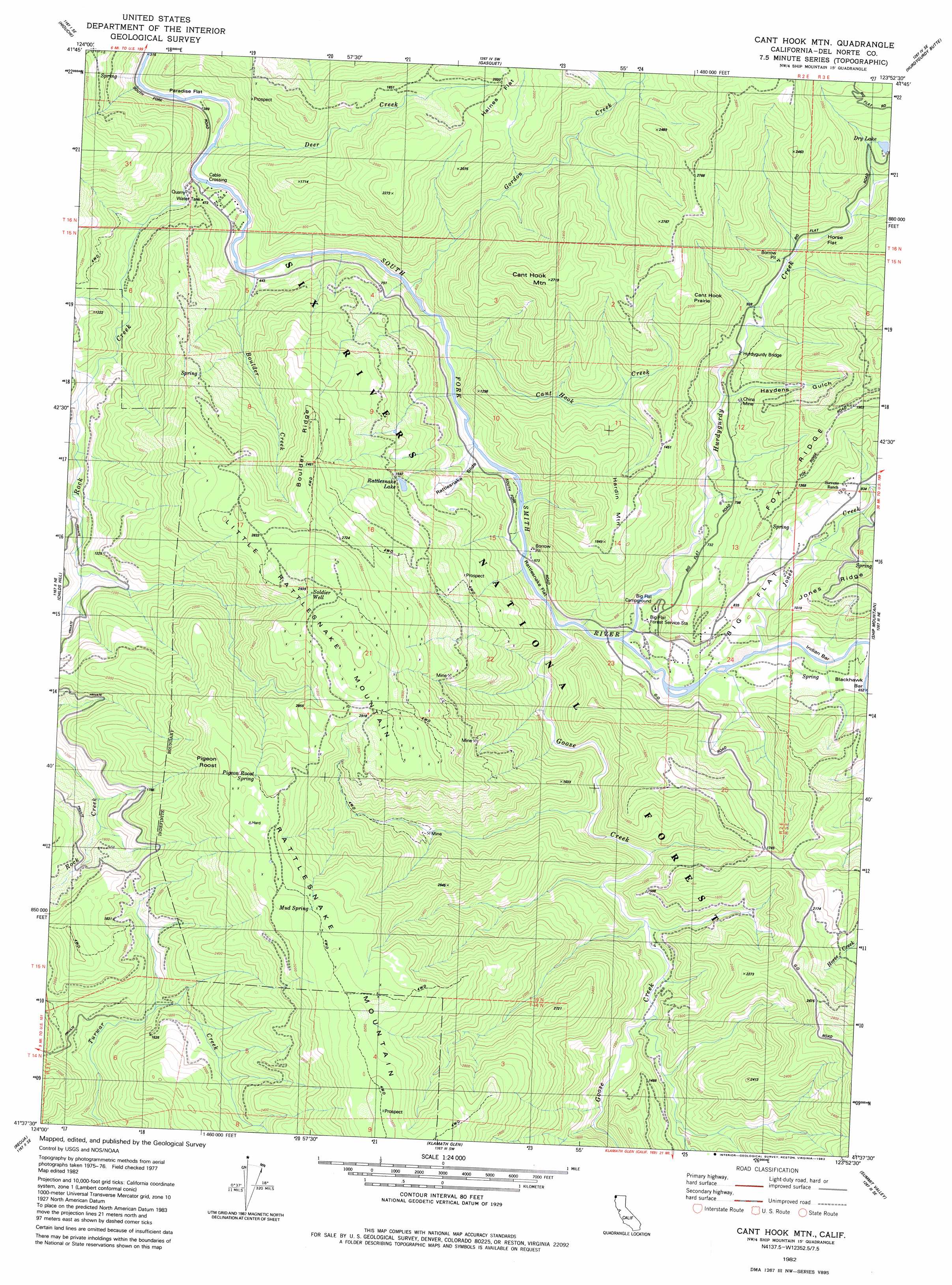
Cant Hook Mountain Topo Map California
To zoom in, hover over the map of Cant Hook Mountain
USGS Topo Quad 41123f8 - 1:24,000 scale
| Topo Map Name: | Cant Hook Mountain |
| USGS Topo Quad ID: | 41123f8 |
| Print Size: | ca. 21 1/4" wide x 27" high |
| Southeast Coordinates: | 41.625° N latitude / 123.875° W longitude |
| Map Center Coordinates: | 41.6875° N latitude / 123.9375° W longitude |
| U.S. State: | CA |
| Filename: | o41123f8.jpg |
| Download Map JPG Image: | Cant Hook Mountain topo map 1:24,000 scale |
| Map Type: | Topographic |
| Topo Series: | 7.5´ |
| Map Scale: | 1:24,000 |
| Source of Map Images: | United States Geological Survey (USGS) |
| Alternate Map Versions: |
Cant Hook Mtn CA 1982, updated 1982 Download PDF Buy paper map Cant Hook Mtn CA 1982, updated 1982 Download PDF Buy paper map Cant Hook Mtn CA 1982, updated 1982 Download PDF Buy paper map Cant Hook Mountain CA 1997, updated 2001 Download PDF Buy paper map Canthook Mountain CA 2012 Download PDF Buy paper map Canthook Mountain CA 2015 Download PDF Buy paper map |
| FStopo: | US Forest Service topo Canthook Mountain is available: Download FStopo PDF Download FStopo TIF |
1:24,000 Topo Quads surrounding Cant Hook Mountain
Smith River |
High Divide |
High Plateau Mountain |
Shelly Creek Ridge |
Broken Rib Mountain |
Crescent City |
Hiouchi |
Gasquet |
Hurdygurdy Butte |
Devils Punchbowl |
Sister Rocks |
Childs Hill |
Cant Hook Mountain |
Ship Mountain |
Prescott Mountain |
Requa |
Klamath Glen |
Summit Valley |
Chimney Rock |
|
Fern Canyon |
Ah Pah Ridge |
Blue Creek Mountain |
Lonesome Ridge |
> Back to 41123e1 at 1:100,000 scale
> Back to 41122a1 at 1:250,000 scale
> Back to U.S. Topo Maps home
Cant Hook Mountain topo map: Gazetteer
Cant Hook Mountain: Areas
Canthook Prairie elevation 643m 2109′Cant Hook Mountain: Bars
Indian Bar elevation 195m 639′Cant Hook Mountain: Bridges
Hurdygurdy Bridge elevation 253m 830′Cant Hook Mountain: Crossings
Cable Crossing elevation 106m 347′Cant Hook Mountain: Flats
Big Flat elevation 251m 823′Haines Flat elevation 587m 1925′
Horse Flat elevation 394m 1292′
Paradise Flat elevation 107m 351′
Rattlesnake Flat elevation 175m 574′
Cant Hook Mountain: Lakes
Dry Lake elevation 456m 1496′Rattlesnake Lake elevation 469m 1538′
Cant Hook Mountain: Mines
China Mine elevation 292m 958′Chrome Mine elevation 573m 1879′
Cant Hook Mountain: Ridges
Boulder Ridge elevation 745m 2444′Cant Hook Mountain: Springs
Mud Spring elevation 1004m 3293′Pigeon Roost Spring elevation 961m 3152′
Cant Hook Mountain: Streams
Blackhawk Creek elevation 201m 659′Boulder Creek elevation 121m 396′
Canthook Creek elevation 129m 423′
Deer Creek elevation 140m 459′
Goose Creek elevation 169m 554′
Gordon Creek elevation 122m 400′
Hurdygurdy Creek elevation 170m 557′
Jones Creek elevation 189m 620′
Rock Creek elevation 106m 347′
Cant Hook Mountain: Summits
Canthook Mountain elevation 816m 2677′Hardin Mountain elevation 524m 1719′
Little Rattlesnake Mountain elevation 973m 3192′
Pigeon Roost elevation 979m 3211′
Rattlesnake Mountain elevation 1107m 3631′
Cant Hook Mountain: Trails
Paradise Trail elevation 449m 1473′Rattlesnake Trail elevation 465m 1525′
Cant Hook Mountain: Valleys
Haydens Gulch elevation 244m 800′Cant Hook Mountain: Wells
Soldier Well elevation 898m 2946′Cant Hook Mountain digital topo map on disk
Buy this Cant Hook Mountain topo map showing relief, roads, GPS coordinates and other geographical features, as a high-resolution digital map file on DVD: