Gasquet Topo Map California
To zoom in, hover over the map of Gasquet
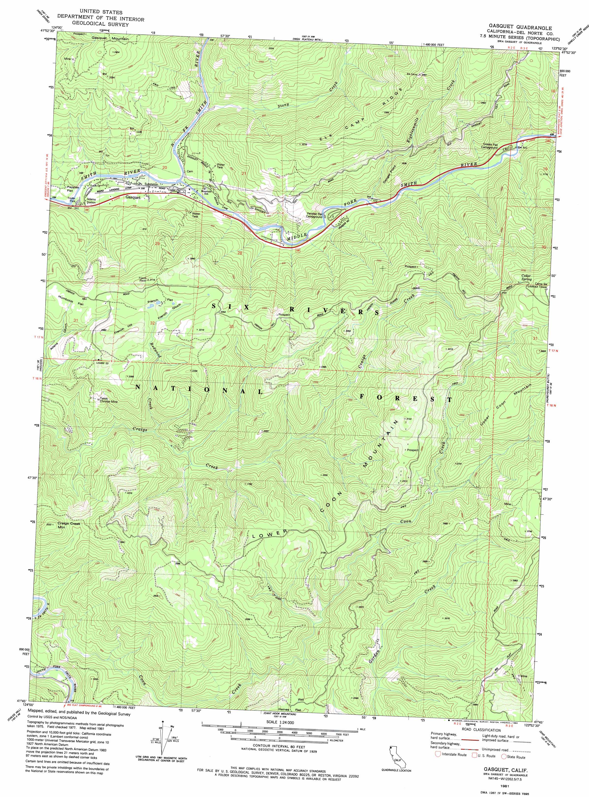
USGS Topo Quad 41123g8 - 1:24,000 scale
| Topo Map Name: | Gasquet |
| USGS Topo Quad ID: | 41123g8 |
| Print Size: | ca. 21 1/4" wide x 27" high |
| Southeast Coordinates: | 41.75° N latitude / 123.875° W longitude |
| Map Center Coordinates: | 41.8125° N latitude / 123.9375° W longitude |
| U.S. State: | CA |
| Filename: | o41123g8.jpg |
| Download Map JPG Image: | Gasquet topo map 1:24,000 scale |
| Map Type: | Topographic |
| Topo Series: | 7.5´ |
| Map Scale: | 1:24,000 |
| Source of Map Images: | United States Geological Survey (USGS) |
| Alternate Map Versions: |
Gasquet CA 1981, updated 1982 Download PDF Buy paper map Gasquet CA 1997, updated 2001 Download PDF Buy paper map Gasquet CA 2012 Download PDF Buy paper map Gasquet CA 2015 Download PDF Buy paper map |
| FStopo: | US Forest Service topo Gasquet is available: Download FStopo PDF Download FStopo TIF |
1:24,000 Topo Quads surrounding Gasquet
Mount Emily |
Fourth Of July Creek |
Biscuit Hill |
Buckskin Peak |
O'Brien |
Smith River |
High Divide |
High Plateau Mountain |
Shelly Creek Ridge |
Broken Rib Mountain |
Crescent City |
Hiouchi |
Gasquet |
Hurdygurdy Butte |
Devils Punchbowl |
Sister Rocks |
Childs Hill |
Cant Hook Mountain |
Ship Mountain |
Prescott Mountain |
Requa |
Klamath Glen |
Summit Valley |
Chimney Rock |
> Back to 41123e1 at 1:100,000 scale
> Back to 41122a1 at 1:250,000 scale
> Back to U.S. Topo Maps home
Gasquet topo map: Gazetteer
Gasquet: Airports
Ward Field elevation 110m 360′Gasquet: Canals
French Placer Canal elevation 697m 2286′Gasquet: Cliffs
Danger Point elevation 448m 1469′Gasquet: Flats
French Flat elevation 575m 1886′Humboldt Flat elevation 521m 1709′
Pappas Flat elevation 114m 374′
Gasquet: Mines
Angela Mine elevation 448m 1469′Big Dipper Mine elevation 1110m 3641′
Black Jack Mine elevation 370m 1213′
Camp Eight Mine elevation 854m 2801′
Coon Creek Number 1 Mine elevation 800m 2624′
Cooncan Mine elevation 765m 2509′
Fairview Mine elevation 161m 528′
Fourth of July Mine elevation 366m 1200′
French Hill Placer Mine elevation 564m 1850′
Gilmore Mine elevation 624m 2047′
Hawkins Mine elevation 372m 1220′
Margy Mine elevation 163m 534′
Morrell Placer Mine elevation 581m 1906′
Negrohead Mine elevation 381m 1250′
Patterson Mine elevation 1064m 3490′
Sunrise Mine elevation 758m 2486′
Tyson Chrome Mine elevation 454m 1489′
Zinc Saddle Mine elevation 723m 2372′
Gasquet: Populated Places
Adams Station elevation 103m 337′Darlingtonia elevation 141m 462′
French Hill elevation 568m 1863′
Gasquet elevation 116m 380′
Gasquet: Springs
Cedar Spring elevation 1033m 3389′Gasquet: Streams
Coon Creek elevation 85m 278′Eighteenmile Creek elevation 139m 456′
Middle Fork Smith River elevation 96m 314′
North Fork Smith River elevation 99m 324′
North Fork Smith River elevation 96m 314′
Redwood Creek elevation 198m 649′
Stony Creek elevation 136m 446′
Gasquet: Summits
Craigs Creek Mountain elevation 668m 2191′French Hill elevation 631m 2070′
Lower Coon Mountain elevation 728m 2388′
Gasquet: Trails
French Hill Trail elevation 315m 1033′Gasquet: Valleys
French Gulch elevation 547m 1794′Gasquet digital topo map on disk
Buy this Gasquet topo map showing relief, roads, GPS coordinates and other geographical features, as a high-resolution digital map file on DVD: