Kangaroo Mountain Topo Map California
To zoom in, hover over the map of Kangaroo Mountain
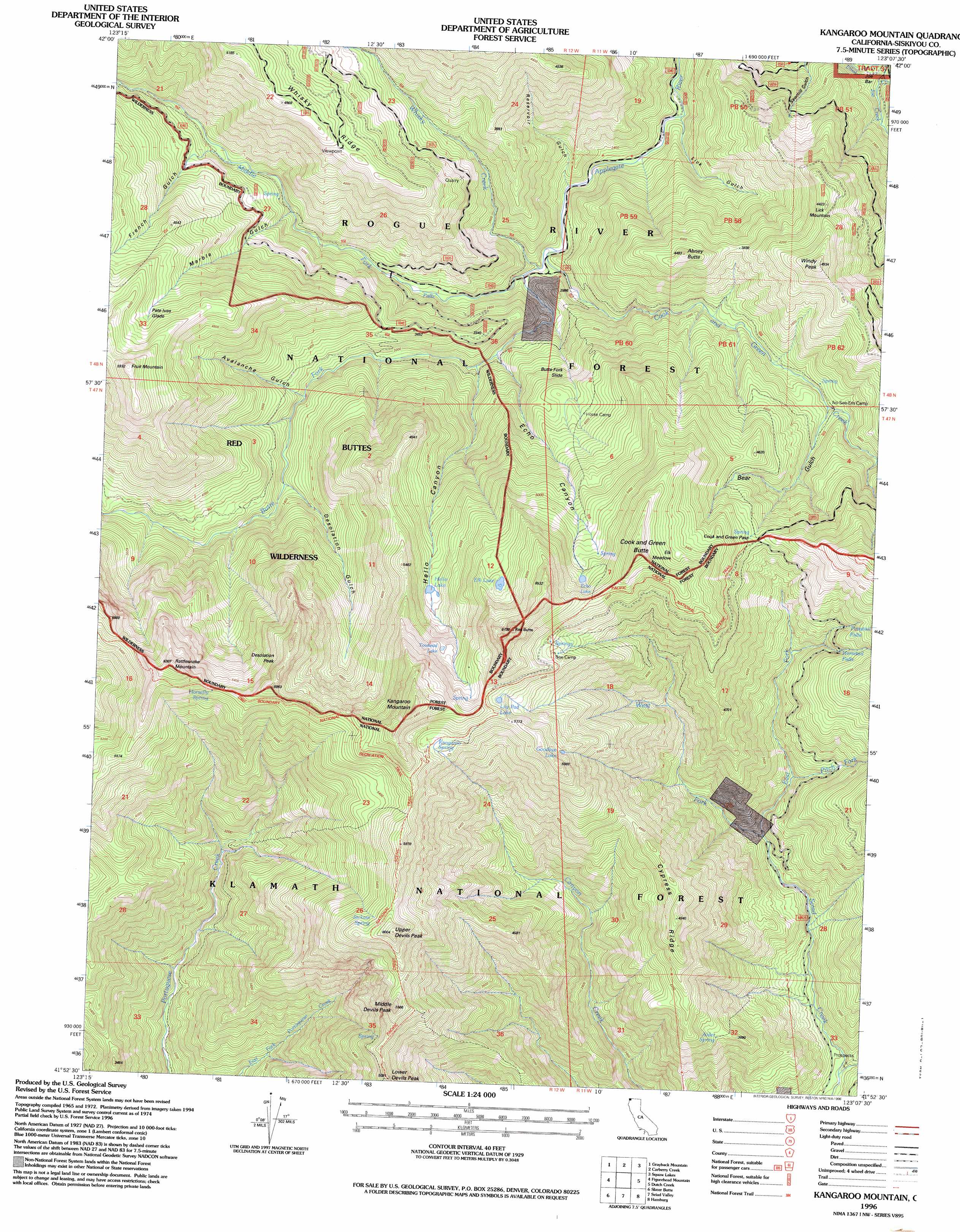
USGS Topo Quad 41123h2 - 1:24,000 scale
| Topo Map Name: | Kangaroo Mountain |
| USGS Topo Quad ID: | 41123h2 |
| Print Size: | ca. 21 1/4" wide x 27" high |
| Southeast Coordinates: | 41.875° N latitude / 123.125° W longitude |
| Map Center Coordinates: | 41.9375° N latitude / 123.1875° W longitude |
| U.S. State: | CA |
| Filename: | o41123h2.jpg |
| Download Map JPG Image: | Kangaroo Mountain topo map 1:24,000 scale |
| Map Type: | Topographic |
| Topo Series: | 7.5´ |
| Map Scale: | 1:24,000 |
| Source of Map Images: | United States Geological Survey (USGS) |
| Alternate Map Versions: |
Kangaroo Mtn. CA 1980, updated 1980 Download PDF Buy paper map Kangaroo Mtn. CA 1980, updated 1982 Download PDF Buy paper map Kangaroo Mountain CA 1996, updated 1998 Download PDF Buy paper map Kangaroo Mountain CA 2012 Download PDF Buy paper map Kangaroo Mountain CA 2015 Download PDF Buy paper map |
| FStopo: | US Forest Service topo Kangaroo Mountain is available: Download FStopo PDF Download FStopo TIF |
1:24,000 Topo Quads surrounding Kangaroo Mountain
Kerby Peak |
Williams |
Tallowbox Mountain |
Ruch |
Sterling Creek |
Oregon Caves |
Grayback Mountain |
Carberry Creek |
Squaw Lakes |
Dutchman Peak |
Deadman Point |
Figurehead Mountain |
Kangaroo Mountain |
Dutch Creek |
Condrey Mountain |
Happy Camp |
Slater Butte |
Seiad Valley |
Hamburg |
Horse Creek |
Clear Creek |
Huckleberry Mountain |
Grider Valley |
Scott Bar |
Russell Peak |
> Back to 41123e1 at 1:100,000 scale
> Back to 41122a1 at 1:250,000 scale
> Back to U.S. Topo Maps home
Kangaroo Mountain topo map: Gazetteer
Kangaroo Mountain: Falls
Horsetail Falls elevation 1321m 4333′Ponytail Falls elevation 1317m 4320′
Kangaroo Mountain: Flats
Cameron Meadow elevation 903m 2962′Elk Meadow elevation 1644m 5393′
Pete Ives Glade elevation 1472m 4829′
Kangaroo Mountain: Forests
Rogue River National Forest elevation 1359m 4458′Kangaroo Mountain: Gaps
Cook and Green Pass elevation 1468m 4816′Kangaroo Mountain: Lakes
Echo Lake elevation 1707m 5600′Elk Lake elevation 1715m 5626′
Goodbye Lake elevation 1707m 5600′
Hello Lake elevation 1451m 4760′
Lily Pad Lake elevation 1756m 5761′
Towhead Lake elevation 1644m 5393′
Kangaroo Mountain: Ridges
Cypress Ridge elevation 1506m 4940′Kangaroo Mountain: Slopes
Butte Fork Slide elevation 1050m 3444′Kangaroo Mountain: Springs
Alder Spring elevation 1090m 3576′Horsefly Spring elevation 1723m 5652′
Jackass Spring elevation 1682m 5518′
Kangaroo Spring elevation 1730m 5675′
Kangaroo Mountain: Streams
Butte Fork Applegate River elevation 780m 2559′Cook and Green Creek elevation 734m 2408′
East Fork Seiad Creek elevation 817m 2680′
Joe Creek elevation 639m 2096′
Middle Fork Applegate River elevation 766m 2513′
Pitch Fork elevation 865m 2837′
West Fork Seiad Creek elevation 817m 2680′
Whisky Creek elevation 722m 2368′
Kangaroo Mountain: Summits
Abney Butte elevation 1269m 4163′Cook and Green Butte elevation 1908m 6259′
Desolation Peak elevation 1846m 6056′
Fruit Mountain elevation 1802m 5912′
Kangaroo Mountain elevation 2033m 6669′
Lick Mountain elevation 1190m 3904′
Lower Devils Peak elevation 1533m 5029′
Middle Devils Peak elevation 1678m 5505′
Rattlesnake Mountain elevation 1908m 6259′
Red Butte elevation 1938m 6358′
Upper Devils Peak elevation 1812m 5944′
Windy Peak elevation 1418m 4652′
Kangaroo Mountain: Trails
Horse Camp Trail elevation 1223m 4012′Kangaroo Mountain: Valleys
Avalanche Gulch elevation 938m 3077′Bear Gulch elevation 1118m 3667′
Desolation Gulch elevation 983m 3225′
Echo Canyon elevation 838m 2749′
French Gulch elevation 990m 3248′
Hello Canyon elevation 911m 2988′
Lick Gulch elevation 662m 2171′
Marble Gulch elevation 927m 3041′
Panther Gulch elevation 604m 1981′
Reservoir Gulch elevation 688m 2257′
Kangaroo Mountain digital topo map on disk
Buy this Kangaroo Mountain topo map showing relief, roads, GPS coordinates and other geographical features, as a high-resolution digital map file on DVD: