Provincetown Topo Map Massachusetts
To zoom in, hover over the map of Provincetown
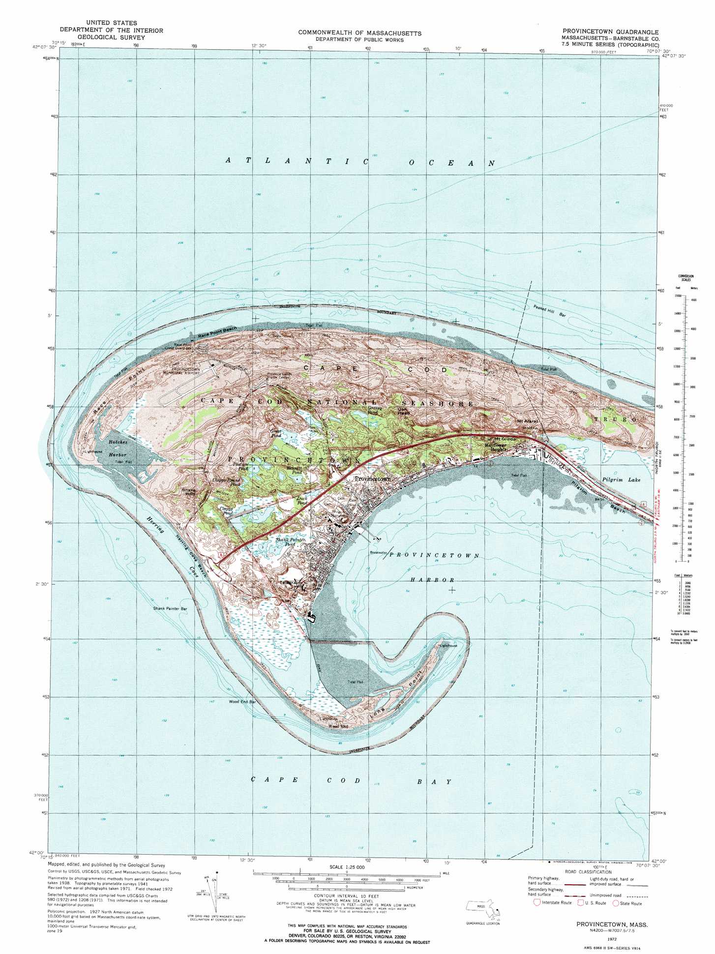
USGS Topo Quad 42070a2 - 1:25,000 scale
| Topo Map Name: | Provincetown |
| USGS Topo Quad ID: | 42070a2 |
| Print Size: | ca. 21 1/4" wide x 27" high |
| Southeast Coordinates: | 42° N latitude / 70.125° W longitude |
| Map Center Coordinates: | 42.0625° N latitude / 70.1875° W longitude |
| U.S. State: | MA |
| Filename: | l42070a2.jpg |
| Download Map JPG Image: | Provincetown topo map 1:25,000 scale |
| Map Type: | Topographic |
| Topo Series: | 7.5´ |
| Map Scale: | 1:25,000 |
| Source of Map Images: | United States Geological Survey (USGS) |
| Alternate Map Versions: |
Provincetown MA 1972, updated 1974 Download PDF Buy paper map Provincetown MA 1972, updated 1978 Download PDF Buy paper map Provincetown MA 1972, updated 1978 Download PDF Buy paper map Provincetown MA 1977, updated 1981 Download PDF Buy paper map |
1:24,000 Topo Quads surrounding Provincetown
Provincetown |
North Truro |
|||
Wellfleet |
||||
Orleans |
> Back to 42070a1 at 1:100,000 scale
> Back to 42070a1 at 1:250,000 scale
> Back to U.S. Topo Maps home
Provincetown topo map: Gazetteer
Provincetown: Airports
Provincetown Municipal Airport elevation 2m 6′Provincetown: Bars
Long Point elevation 4m 13′Peaked Hill Bar elevation 0m 0′
Race Point elevation 5m 16′
Shank Painter Bar elevation 0m 0′
Wood End Bar elevation 0m 0′
Provincetown: Bays
Herring Cove elevation 0m 0′Provincetown Harbor elevation 0m 0′
Race Run elevation 4m 13′
Provincetown: Beaches
Herring Cove Beach elevation 5m 16′Race Point Beach elevation 0m 0′
Provincetown: Harbors
East Harbor elevation 0m 0′Hatches Harbor elevation 1m 3′
Provincetown: Lakes
Bennett Pond elevation 1m 3′Blackwater Pond elevation 1m 3′
Clapps Pond elevation 1m 3′
Clapps Round Pond elevation 1m 3′
Duck Pond elevation 3m 9′
Grassy Pond elevation 11m 36′
Great Pond elevation 1m 3′
Pasture Pond elevation 1m 3′
Shank Painter Pond elevation 1m 3′
Provincetown: Populated Places
Beach Point elevation 0m 0′Mayflower Heights elevation 9m 29′
Provincetown elevation 10m 32′
Wood End elevation 3m 9′
Provincetown: Post Offices
Provincetown Post Office elevation 1m 3′Provincetown: Ranges
Dunes of the Provincelands elevation 15m 49′Provincetown: Summits
High Pole Hill elevation 15m 49′Millers Hill elevation 16m 52′
Mount Ararat elevation 14m 45′
Mount Gilboa elevation 12m 39′
Oak Head elevation 21m 68′
Ocean View Hill elevation 26m 85′
Snake Hills elevation 10m 32′
Telegraph Hill elevation 24m 78′
Town Hill elevation 15m 49′
Provincetown: Swamps
Long Point Marshes elevation 0m 0′Provincetown: Trails
Beach Forest Trail elevation 13m 42′Provincetown digital topo map on disk
Buy this Provincetown topo map showing relief, roads, GPS coordinates and other geographical features, as a high-resolution digital map file on DVD:
Maine, New Hampshire, Rhode Island & Eastern Massachusetts
Buy digital topo maps: Maine, New Hampshire, Rhode Island & Eastern Massachusetts