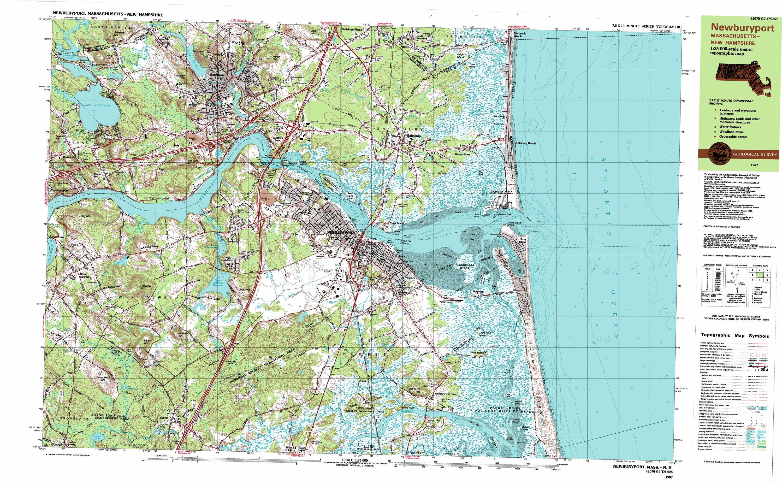
Newburyport East Topo Map Massachusetts
To zoom in, hover over the map of Newburyport East
USGS Topo Quad 42070g7 - 1:25,000 scale
| Topo Map Name: | Newburyport East |
| USGS Topo Quad ID: | 42070g7 |
| Print Size: | ca. 39" wide x 24" high |
| Southeast Coordinates: | 42.75° N latitude / 70.75° W longitude |
| Map Center Coordinates: | 42.8125° N latitude / 70.875° W longitude |
| U.S. States: | MA, NH |
| Filename: | k42070g7.jpg |
| Download Map JPG Image: | Newburyport East topo map 1:25,000 scale |
| Map Type: | Topographic |
| Topo Series: | 7.5´x15´ |
| Map Scale: | 1:25,000 |
| Source of Map Images: | United States Geological Survey (USGS) |
| Alternate Map Versions: |
Newburyport MA 1985, updated 1985 Download PDF Buy paper map Newburyport MA 1987, updated 1987 Download PDF Buy paper map Newburyport MA 1987, updated 1987 Download PDF Buy paper map |
1:24,000 Topo Quads surrounding Newburyport East
Epping |
Newmarket |
Portsmouth |
Kittery |
|
Kingston |
Hampton |
Isles of Shoals |
||
Haverhill |
Newburyport East |
|||
South Groveland |
Ipswich |
Rockport |
||
Reading |
Salem |
Gloucester |
> Back to 42070e1 at 1:100,000 scale
> Back to 42070a1 at 1:250,000 scale
> Back to U.S. Topo Maps home
Newburyport East topo map: Gazetteer
Newburyport East: Airports
Lake Gardner Seaplane Base elevation 25m 82′Meadowbrook Airport elevation 34m 111′
Plum Island Airport elevation 3m 9′
Newburyport East: Bars
Black Rocks elevation 0m 0′Breaking Rocks elevation 0m 0′
Butlers Toothpick (historical) elevation 1m 3′
Half Tide Rocks elevation 0m 0′
North Pier elevation 0m 0′
Outer Badger Rocks (historical) elevation 0m 0′
South Pier elevation 0m 0′
Sow and Pigs (historical) elevation 1m 3′
Newburyport East: Bays
Hate Cove elevation 2m 6′The Basin elevation 0m 0′
Newburyport East: Beaches
Salisbury Beach elevation 1m 3′Sandy Beach elevation 0m 0′
Newburyport East: Bridges
Old Town Bridge elevation 0m 0′Rocks Bridge elevation 0m 0′
Whittier Memorial Bridge elevation 0m 0′
Newburyport East: Capes
Cape Merrill elevation 0m 0′Coffin Point elevation 0m 0′
Ireland Point elevation 1m 3′
Long Point elevation 0m 0′
Plum Island Point elevation 0m 0′
Newburyport East: Channels
The Thorofare elevation 0m 0′Newburyport East: Dams
Artichoke River Dam elevation 1m 3′Bailey Pond Dam elevation 11m 36′
Lake Attitash Dam elevation 29m 95′
Lake Gardner Dam elevation 25m 82′
Lower Artichoke Reservoir Dam elevation 3m 9′
Mill Pond Dam elevation 19m 62′
Parker River Dam elevation 11m 36′
Parker River Dam elevation 13m 42′
Parker River Dam at Central Street elevation 3m 9′
Tuxbury Pond Outlet Dam elevation 28m 91′
Newburyport East: Flats
Joppa Flats elevation 0m 0′Newburyport East: Guts
Plum Island River elevation 0m 0′Newburyport East: Islands
Allen Rock elevation 2m 6′Badgers Rock elevation 0m 0′
Browns Island elevation 0m 0′
Carr Island elevation 2m 6′
Chaces Island elevation 1m 3′
Deer Island elevation 1m 3′
Dole Island elevation 1m 3′
Eagle Island elevation 5m 16′
Gangway Rock elevation 0m 0′
Kents Island elevation 7m 22′
Little Pine Island elevation 1m 3′
Lunt Rock elevation 0m 0′
Majors Rock elevation 2m 6′
Pine Island elevation 1m 3′
Plum Island elevation 0m 0′
Pork Island elevation 0m 0′
Ram Island elevation 2m 6′
Trues Island elevation 5m 16′
Woodbridge Island elevation 1m 3′
Wrights Island elevation 3m 9′
Wrights Island elevation 2m 6′
Newburyport East: Lakes
Crane Pond elevation 19m 62′Frog Pond elevation 18m 59′
Little Crane Pond elevation 20m 65′
Quills Pond elevation 7m 22′
Tuxbury Pond elevation 28m 91′
Newburyport East: Parks
Alliance Park elevation 4m 13′Amesbury and Salisbury Mills Village Historic District elevation 20m 65′
Amesbury Town Park elevation 27m 88′
Atkinson Common elevation 14m 45′
Bartlett Mall elevation 17m 55′
Batchelder Park elevation 93m 305′
Brown Square elevation 10m 32′
Carr Island State Reservation elevation 6m 19′
Cashman Park elevation 2m 6′
Collins Street Playground elevation 17m 55′
Downfall Wildlife Management Area elevation 14m 45′
Salisbury Beach State Reservation elevation 3m 9′
Newburyport East: Populated Places
Amesbury elevation 17m 55′Atlantic elevation 22m 72′
Browns Point elevation 2m 6′
Byfield elevation 20m 65′
Curzon Mill elevation 4m 13′
Cushing elevation 2m 6′
Joppa elevation 4m 13′
Knights Crossing elevation 6m 19′
Merrimacport elevation 15m 49′
Newbury Old Town elevation 11m 36′
Newburyport elevation 11m 36′
Pine Island elevation 1m 3′
Plum Island elevation 5m 16′
Plumbush elevation 2m 6′
Rings Island elevation 7m 22′
Salisbury elevation 9m 29′
Salisbury Beach elevation 3m 9′
Salisbury Plains elevation 23m 75′
Salisbury Point elevation 24m 78′
South Seabrook elevation 16m 52′
Upper Green elevation 11m 36′
West Newbury elevation 40m 131′
Newburyport East: Post Offices
Amesbury Post Office elevation 15m 49′Amesbury Post Office (historical) elevation 25m 82′
Byfield Post Office (historical) elevation 21m 68′
Merrimacport Post Office (historical) elevation 18m 59′
Salisbury Point Post Office (historical) elevation 7m 22′
Salisbury Post Office (historical) elevation 7m 22′
West Newsbury Post Office (historical) elevation 36m 118′
Newburyport East: Reservoirs
Artichoke River Reservoir elevation 1m 3′Bailey Pond elevation 11m 36′
Clarks Pond elevation 4m 13′
Frog Pond elevation 17m 55′
Lake Attitash elevation 0m 0′
Lake Gardner elevation 24m 78′
Lower Artichoke Reservoir elevation 4m 13′
Mill Pond elevation 19m 62′
Parker River Reservoir elevation 13m 42′
Parker River Reservoir elevation 3m 9′
Parker River Reservoir elevation 11m 36′
Pattens Pond elevation 11m 36′
Tuxbury Pond elevation 28m 91′
Upper Artichoke Reservoir elevation 4m 13′
Newburyport East: Ridges
Bear Hill elevation 55m 180′Newburyport East: Streams
Allen Creek elevation 1m 3′Artichoke River elevation 0m 0′
Back River elevation 28m 91′
Back River elevation 2m 6′
Back River elevation 0m 0′
Back River elevation 28m 91′
Back River elevation 2m 6′
Beaver Brook elevation 20m 65′
Black Rock Creek elevation 0m 0′
Carolton Creek elevation 0m 0′
Cobbler Brook elevation 0m 0′
Dead Creek elevation 1m 3′
Fox Island Creek elevation 1m 3′
Goodwin Creek elevation 2m 6′
Indian River elevation 0m 0′
Jericho Creek elevation 0m 0′
Little Pine Island Creek elevation 0m 0′
Little River elevation 0m 0′
Little River elevation 1m 3′
Merrimack River elevation 0m 0′
Mill River elevation 0m 0′
Morrill Creek elevation 0m 0′
Mud Creek elevation 0m 0′
Nichols Creek elevation 0m 0′
Parker River elevation 0m 0′
Pine Island Creek elevation 1m 3′
Plumbush Creek elevation 0m 0′
Powwow River elevation 4m 13′
Sawyer Creek elevation 1m 3′
Shad Creek elevation 0m 0′
Town Creek elevation 1m 3′
Newburyport East: Summits
Archelaus Hill elevation 74m 242′Batt Hill elevation 51m 167′
Crane Neck Hill elevation 69m 226′
Indian Hill elevation 40m 131′
Isleys Hill elevation 62m 203′
LIttle Old Town Hill elevation 34m 111′
Lone Tree Hill elevation 68m 223′
Long Hill elevation 59m 193′
Mundy Hill elevation 60m 196′
Old Town Hill elevation 46m 150′
Pipestave Hill elevation 58m 190′
Pond Hill elevation 74m 242′
Poplar Hill elevation 44m 144′
Powder House Hill elevation 46m 150′
Powwow Hill elevation 99m 324′
Ring Hill elevation 64m 209′
Sawyers Hill elevation 91m 298′
Turkey Hill elevation 47m 154′
Turkey Hill elevation 37m 121′
Whittier Hill elevation 76m 249′
Newburyport East: Swamps
Ash Swamp elevation 20m 65′Blackwater River Marshes elevation 1m 3′
Floating Island elevation 8m 26′
Great Swamp elevation 29m 95′
Little River Marshes elevation 0m 0′
Parker River Marshes elevation 2m 6′
Plum Island River Marshes elevation 1m 3′
Town Creek Marshes elevation 1m 3′
Newburyport East: Woods
Baker Woods elevation 10m 32′Newburyport East digital topo map on disk
Buy this Newburyport East topo map showing relief, roads, GPS coordinates and other geographical features, as a high-resolution digital map file on DVD:
Maine, New Hampshire, Rhode Island & Eastern Massachusetts
Buy digital topo maps: Maine, New Hampshire, Rhode Island & Eastern Massachusetts