Wrentham Topo Map Massachusetts
To zoom in, hover over the map of Wrentham
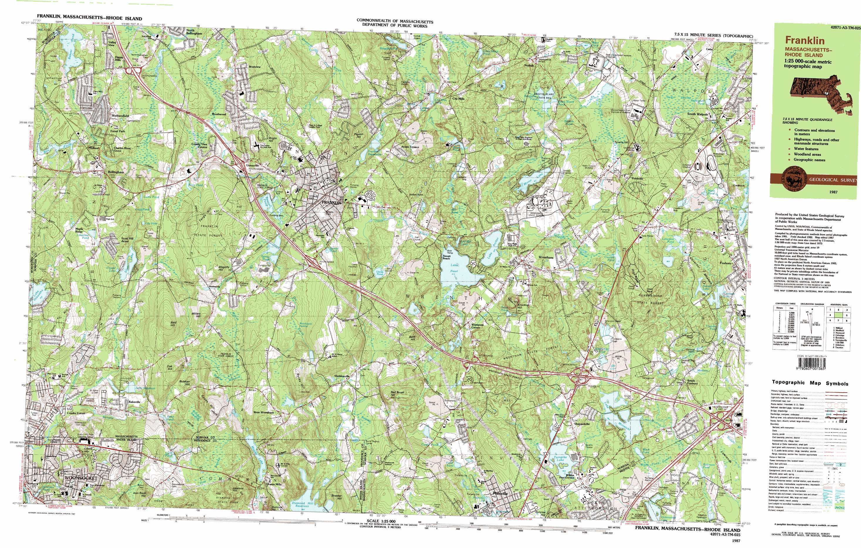
USGS Topo Quad 42071a3 - 1:25,000 scale
| Topo Map Name: | Wrentham |
| USGS Topo Quad ID: | 42071a3 |
| Print Size: | ca. 39" wide x 24" high |
| Southeast Coordinates: | 42° N latitude / 71.25° W longitude |
| Map Center Coordinates: | 42.0625° N latitude / 71.375° W longitude |
| U.S. State: | MA |
| Filename: | k42071a3.jpg |
| Download Map JPG Image: | Wrentham topo map 1:25,000 scale |
| Map Type: | Topographic |
| Topo Series: | 7.5´x15´ |
| Map Scale: | 1:25,000 |
| Source of Map Images: | United States Geological Survey (USGS) |
| Alternate Map Versions: |
Franklin MA 1987, updated 1987 Download PDF Buy paper map Franklin MA 1987, updated 1987 Download PDF Buy paper map |
1:24,000 Topo Quads surrounding Wrentham
Marlborough |
Natick |
Boston South |
||
Milford |
Medfield |
Blue Hills |
||
Blackstone |
Wrentham |
Brockton |
||
Georgiaville |
Attleboro |
Taunton |
||
North Scituate |
East Providence |
Assonet |
> Back to 42071a1 at 1:100,000 scale
> Back to 42070a1 at 1:250,000 scale
> Back to U.S. Topo Maps home
Wrentham topo map: Gazetteer
Wrentham: Airports
Rodman Heliport elevation 76m 249′Rodman Nunber 2 Heliport elevation 80m 262′
Wrentham: Crossings
Interchange Eighteen elevation 66m 216′Interchange Fifteen elevation 85m 278′
Interchange Fourteen elevation 62m 203′
Interchange Seventeen elevation 66m 216′
Interchange Six and Thirteen elevation 58m 190′
Interchange Sixteen elevation 100m 328′
Wrentham: Dams
Box Pond Dam elevation 77m 252′Bristol Blake State Reservoir Dam elevation 57m 187′
Bush Pond Dam Number Two elevation 53m 173′
Carpenter Pond Dam elevation 70m 229′
City Mills Pond Dam elevation 42m 137′
Cocasset Lake Pond Dam elevation 70m 229′
Crackrock Pond Dam elevation 81m 265′
Furnace Lake Dam elevation 80m 262′
Hawes Pond Dam elevation 63m 206′
Lake Hiawatha Dam elevation 89m 291′
Lake Mirimichi Dam elevation 49m 160′
Maple Street Pond Dam elevation 69m 226′
Rabbitt Hill Pond Dam elevation 54m 177′
Red Dam elevation 66m 216′
Wrentham: Forests
Foxborough State Forest elevation 98m 321′Wrentham State Forest elevation 98m 321′
Wrentham: Lakes
Beaver Pond elevation 70m 229′Beaver Pond elevation 72m 236′
Bristols Pond elevation 47m 154′
Cargill Pond elevation 70m 229′
Carls Pond elevation 92m 301′
Comeys Pond elevation 47m 154′
Cress Brook Pond elevation 50m 164′
Crocker Pond elevation 62m 203′
Crystal Lake elevation 69m 226′
Curtis Pond elevation 85m 278′
Fuller Pond elevation 65m 213′
Kingfisher Pond elevation 53m 173′
Kingsbury Pond elevation 50m 164′
Lake Archer elevation 58m 190′
Lakeview Pond elevation 90m 295′
Lakeview Pond elevation 83m 272′
Lily Hole elevation 75m 246′
Long Pond elevation 77m 252′
Mann Pond elevation 50m 164′
Mann Pond elevation 80m 262′
Mirror Lake elevation 56m 183′
Plainville Pond elevation 63m 206′
Silver Lake elevation 67m 219′
Spruce Pond elevation 99m 324′
Stony Brook Pond elevation 53m 173′
Sunset Lake elevation 74m 242′
Trout Pond elevation 80m 262′
Turnpike Lake elevation 60m 196′
Uncas Pond elevation 92m 301′
Wetherells Pond elevation 60m 196′
Witch Pond elevation 48m 157′
Wrentham: Parks
Bay State Raceway elevation 75m 246′Cass Park elevation 63m 206′
Dean Junior College Historic District elevation 101m 331′
Dean Junior College Longley Field elevation 87m 285′
Diamond Hill State Park elevation 98m 321′
Gillette Stadium elevation 76m 249′
Schaefer Stadium elevation 95m 311′
Wrentham: Populated Places
Acorn Terrace elevation 80m 262′Bellingham elevation 90m 295′
Benjamins Landing elevation 95m 311′
Brushwood elevation 82m 269′
Cedar elevation 62m 203′
Charles River Grove elevation 83m 272′
City Mills elevation 72m 236′
Country View Estates elevation 58m 190′
Crooks Corner elevation 63m 206′
Forest Park elevation 69m 226′
Franklin elevation 92m 301′
Grants Mills elevation 71m 232′
Happy Hills elevation 89m 291′
Maple Ridge elevation 95m 311′
Midland elevation 74m 242′
Millerville elevation 61m 200′
Norfolk elevation 64m 209′
North Bellingham elevation 67m 219′
North Foxboro elevation 88m 288′
Plainville elevation 72m 236′
Pondville elevation 76m 249′
Rakeville elevation 66m 216′
Robinsonville elevation 49m 160′
Scott Hill Acres elevation 85m 278′
Sheldonville elevation 76m 249′
Shepardville elevation 64m 209′
South Bellingham elevation 68m 223′
South Foxboro elevation 59m 193′
South Walpole elevation 68m 223′
Unionville elevation 82m 269′
Valley View elevation 84m 275′
Wadsworth elevation 84m 275′
Wampum Corner elevation 71m 232′
Wampum Rock elevation 96m 314′
West Foxboro elevation 94m 308′
West Wrentham elevation 117m 383′
Westview elevation 71m 232′
Wethersfield elevation 74m 242′
Wilkins Four Corners elevation 62m 203′
Wrentham elevation 76m 249′
Wrentham: Post Offices
Bellingham Post Office elevation 82m 269′Franklin City Post Office elevation 72m 236′
Franklin Post Office elevation 97m 318′
Norfolk Post Office elevation 68m 223′
Plainville Post Office elevation 65m 213′
South Bellingham Post Office (historical) elevation 64m 209′
Walnut Hill Station Post Office elevation 94m 308′
Wrentham Post Office elevation 76m 249′
Wrentham: Reservoirs
Box Pond elevation 77m 252′Bristol Blake State Reservoir elevation 53m 173′
Bush Pond elevation 53m 173′
Carpenter Pond elevation 70m 229′
City Mills Pond elevation 42m 137′
Cocasset Lake elevation 70m 229′
Crackrock Pond elevation 81m 265′
Darling Pond elevation 86m 282′
Factory Pond elevation 70m 229′
Foundry Pond elevation 80m 262′
Franklin Reservoirs elevation 74m 242′
Hales Pond elevation 66m 216′
Hawes Pond elevation 63m 206′
Jenks Reservoir elevation 69m 226′
Lake Hiawatha elevation 89m 291′
Lake Mirimichi elevation 49m 160′
Lake Pearl elevation 66m 216′
Maple Street Pond elevation 69m 226′
Miscoe Lake elevation 71m 232′
Miscoe Lake elevation 71m 232′
Rabbit Hill Pond elevation 54m 177′
Rays Pond elevation 74m 242′
Robinson Pond elevation 42m 137′
Spring Pond elevation 73m 239′
Stony Brook Pond elevation 57m 187′
Stony Brook Reservoir elevation 53m 173′
Sylvestre Pond elevation 41m 134′
Upper Reservoir elevation 88m 288′
Wrentham: Streams
Arnolds Brook elevation 57m 187′Beaver Brook elevation 65m 213′
Bungay Brook elevation 57m 187′
Burnt Swamp Brook elevation 62m 203′
Burnt Swamp Brook elevation 57m 187′
Cress Brook elevation 66m 216′
Dix Brook elevation 72m 236′
Eagle Brook elevation 53m 173′
Hawthorne Brook elevation 61m 200′
Indian Brook elevation 57m 187′
Miller Brook elevation 42m 137′
Miscoe Brook elevation 75m 246′
Old Mill Brook elevation 60m 196′
Stall Brook elevation 60m 196′
Stony Brook elevation 44m 144′
Uncas Brook elevation 66m 216′
Wrentham: Summits
Bald Hill elevation 145m 475′Bald Hill elevation 120m 393′
Bright Hill elevation 120m 393′
Bucks Hill elevation 138m 452′
Butman Hill elevation 124m 406′
Catamint Hill elevation 157m 515′
Cobble Hill elevation 103m 337′
Cooks Hill elevation 101m 331′
Crackrock elevation 116m 380′
Forge Hill elevation 81m 265′
High Rock elevation 126m 413′
Iron Rock Hill elevation 140m 459′
Knuckup Hill elevation 121m 396′
Magotty Hill elevation 112m 367′
Millers Hill elevation 122m 400′
Oak Hill elevation 139m 456′
Pigeon Hill elevation 113m 370′
Pinnacle elevation 120m 393′
Pinnacle Hill elevation 122m 400′
Red Brush Hill elevation 133m 436′
Scott Hill elevation 107m 351′
Streeter Hill elevation 111m 364′
Wrentham: Swamps
Bungay Swamp elevation 86m 282′Burnt Swamp elevation 73m 239′
Cedar Swamp elevation 61m 200′
Gobernor Meadow elevation 79m 259′
Miscoe Meadow elevation 81m 265′
Pine Swamp elevation 93m 305′
Pine Swamp elevation 94m 308′
Witch Pond Swamp elevation 50m 164′
Woodward Swamp elevation 89m 291′
Wrentham digital topo map on disk
Buy this Wrentham topo map showing relief, roads, GPS coordinates and other geographical features, as a high-resolution digital map file on DVD:
Maine, New Hampshire, Rhode Island & Eastern Massachusetts
Buy digital topo maps: Maine, New Hampshire, Rhode Island & Eastern Massachusetts