Milford Topo Map Massachusetts
To zoom in, hover over the map of Milford
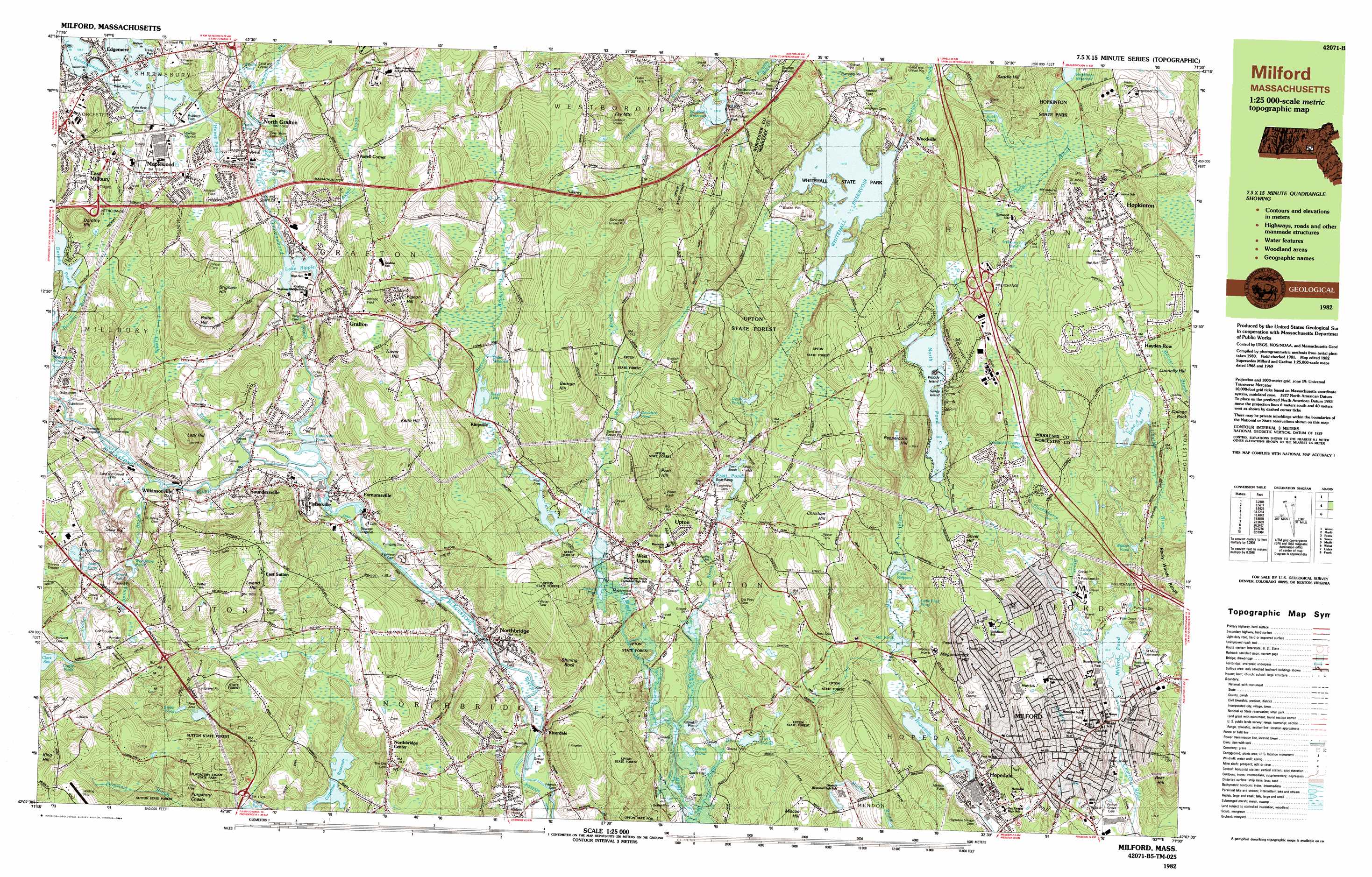
USGS Topo Quad 42071b5 - 1:25,000 scale
| Topo Map Name: | Milford |
| USGS Topo Quad ID: | 42071b5 |
| Print Size: | ca. 39" wide x 24" high |
| Southeast Coordinates: | 42.125° N latitude / 71.5° W longitude |
| Map Center Coordinates: | 42.1875° N latitude / 71.625° W longitude |
| U.S. State: | MA |
| Filename: | k42071b5.jpg |
| Download Map JPG Image: | Milford topo map 1:25,000 scale |
| Map Type: | Topographic |
| Topo Series: | 7.5´x15´ |
| Map Scale: | 1:25,000 |
| Source of Map Images: | United States Geological Survey (USGS) |
| Alternate Map Versions: |
Milford MA 1982, updated 1984 Download PDF Buy paper map |
1:24,000 Topo Quads surrounding Milford
Sterling |
Hudson |
Concord |
||
Worcester North |
Marlborough |
Natick |
||
Worcester South |
Milford |
Medfield |
||
Oxford |
Blackstone |
Wrentham |
||
Thompson |
Chepachet |
Georgiaville |
Attleboro |
> Back to 42071a1 at 1:100,000 scale
> Back to 42070a1 at 1:250,000 scale
> Back to U.S. Topo Maps home
Milford topo map: Gazetteer
Milford: Airports
Waters Airport elevation 217m 711′Milford: Beaches
Point Rok Beach elevation 110m 360′Milford: Canals
Blackstone Canal elevation 81m 265′Milford: Capes
Nelson Point elevation 109m 357′Norcross Point elevation 109m 357′
Sandy Island elevation 109m 357′
Woody Island elevation 106m 347′
Milford: Crossings
Interchange Twenty elevation 99m 324′Milford: Dams
Blackstone River Dam elevation 93m 305′Carpenter Reservoir Dam elevation 104m 341′
Carpenter Reservoir Dike elevation 101m 331′
Cedar Swamp Pond Dam elevation 82m 269′
Chase Road Dam elevation 115m 377′
Clark Reservoir Dam elevation 133m 436′
Dorothy Pond Dam elevation 120m 393′
Echo Lake Dam elevation 103m 337′
Farnumsville Pond Dam elevation 91m 298′
Fisherville Pond Dam elevation 87m 285′
Fiske Millpond Dam elevation 87m 285′
Hayes Pond Dam elevation 105m 344′
Hopedale Pond Dam elevation 83m 272′
Hovey Dam elevation 107m 351′
Lake Luisa Dam elevation 88m 288′
Lake Quigsigamond Dam elevation 109m 357′
Lake Ripple Dam 47 elevation 92m 301′
Lower Westboro Reservoir Dam elevation 162m 531′
Marble Pond Dam elevation 146m 479′
Mill Pond Dam elevation 88m 288′
North Pond Dam elevation 105m 344′
Old Grist Mill Pond Dam elevation 89m 291′
Pratt Pond Upper Dam elevation 96m 314′
Pratts Pond Dam elevation 104m 341′
Riverdale Dam elevation 80m 262′
Silver Lake Dam elevation 106m 347′
Upper Westboro Reservoir Dam elevation 133m 436′
Whitehall Reservoir Dam elevation 101m 331′
Wildwood Lake Dam elevation 94m 308′
Woodbury Pond Dam elevation 122m 400′
Milford: Forests
Sutton State Forest elevation 180m 590′Upton State Forest elevation 153m 501′
Milford: Islands
Oak Island elevation 110m 360′Milford: Lakes
Aldrich Pond elevation 142m 465′Baker Pond elevation 91m 298′
Craddock Crewes Pond elevation 136m 446′
Davidson Pond elevation 104m 341′
Dean Pond elevation 101m 331′
Girard Pond elevation 127m 416′
Goss Pond elevation 81m 265′
Icehouse Pond elevation 115m 377′
Lachary Pond (historical) elevation 81m 265′
Milford Pond elevation 84m 275′
Mill Pond elevation 92m 301′
Pratt Pond elevation 92m 301′
Smith Pond elevation 154m 505′
Windle Pond elevation 116m 380′
Woolshop Pond elevation 111m 364′
Zachary Pond elevation 81m 265′
Milford: Parks
Berry Acres Conservation Area elevation 109m 357′Carrigan Park elevation 140m 459′
Hayward Field elevation 83m 272′
John H Chafee Blackstone River Valley National Heritage Corridor elevation 146m 479′
Prospect Heights Historic District elevation 94m 308′
Purgatory Chasm State Park elevation 144m 472′
Rockdale Common Housing District elevation 117m 383′
Whitehall State Park elevation 108m 354′
Milford: Populated Places
Axtell Corner elevation 120m 393′East Millbury elevation 131m 429′
East Sutton elevation 171m 561′
Edgemere elevation 117m 383′
Farnumsville elevation 94m 308′
Fisherville elevation 98m 321′
Grafton elevation 145m 475′
Hayden Row elevation 129m 423′
Hopedale elevation 83m 272′
Hopkinton elevation 133m 436′
Kittville elevation 109m 357′
Maplewood elevation 119m 390′
Milford elevation 79m 259′
Millbury Junction elevation 115m 377′
North Grafton elevation 102m 334′
North Milford elevation 141m 462′
Northbridge elevation 83m 272′
Northbridge Center elevation 160m 524′
Riverdale elevation 83m 272′
Saundersville elevation 94m 308′
Upton elevation 92m 301′
West Upton elevation 94m 308′
Wilkinsonville elevation 113m 370′
Woodville elevation 104m 341′
Milford: Post Offices
Hopedale Post Office elevation 82m 269′Hopkinton Post Office elevation 131m 429′
Milford Post Office elevation 110m 360′
South Grafton Post Office elevation 99m 324′
Woodville Post Office elevation 106m 347′
Milford: Reservoirs
Blackstone River Reservoir elevation 93m 305′Carpenter Reservoir elevation 104m 341′
Cedar Swamp Pond elevation 82m 269′
Cider Millpond elevation 113m 370′
Clark Reservoir elevation 155m 508′
Cogan Pond elevation 152m 498′
Dorothy Pond elevation 120m 393′
Duck Pond elevation 118m 387′
Echo Lake elevation 109m 357′
Fisherville Pond elevation 91m 298′
Fiske Millpond elevation 94m 308′
Flint Pond elevation 110m 360′
Hayes Pond elevation 105m 344′
Hayes Pond elevation 96m 314′
Hopedale Pond elevation 83m 272′
Hovey Pond elevation 107m 351′
Lake Luisa Reservoir elevation 88m 288′
Lake Ripple elevation 92m 301′
Louisa Lake elevation 88m 288′
Lower Westboro Reservoir elevation 162m 531′
Marble Pond elevation 150m 492′
Mill Pond elevation 88m 288′
North Pond elevation 107m 351′
Pratts Pond elevation 104m 341′
Riverdale Pond elevation 78m 255′
Rockdale Pond elevation 82m 269′
Silver Lake elevation 106m 347′
Taft Pond elevation 99m 324′
Upper Westboro Reservoir elevation 133m 436′
West River Reservoir elevation 94m 308′
Westboro Reservoir elevation 134m 439′
Wildcat Pond elevation 89m 291′
Woodbury Pond elevation 116m 380′
Milford: Streams
Axtell Brook elevation 93m 305′Big Bummet Brook elevation 96m 314′
Cold Spring Brook elevation 99m 324′
Cronin Brook elevation 90m 295′
Godfrey Brook elevation 71m 232′
Huckleberry Brook elevation 82m 269′
Miscoe Brook elevation 112m 367′
Quinsigamond River elevation 91m 298′
Taft Pond Brook elevation 74m 242′
Warren Brook elevation 83m 272′
West Branch Charles River elevation 89m 291′
Milford: Summits
Bear Hill elevation 170m 557′Bear Hill elevation 144m 472′
Brigham Hill elevation 176m 577′
Christian Hill elevation 160m 524′
Dorothy Hill elevation 168m 551′
Fay Mountain elevation 213m 698′
George Hill elevation 183m 600′
Honey Hill elevation 163m 534′
Keith Hill elevation 158m 518′
King Hill elevation 252m 826′
Lazy Hill elevation 164m 538′
Leland Hill elevation 202m 662′
Magomiscock Hill elevation 171m 561′
Misoe Hill elevation 181m 593′
Neck Hill elevation 130m 426′
Ockoocanganset Hill elevation 96m 314′
Peppercorn Hill elevation 174m 570′
Pigeon Hill elevation 194m 636′
Potter Hill elevation 180m 590′
Pratt Hill elevation 181m 593′
Rocky Woods Range elevation 138m 452′
Shining Rock elevation 132m 433′
Silver Hill elevation 121m 396′
Tower Hill elevation 178m 583′
Milford: Valleys
Purgatory Chasm elevation 152m 498′Milford digital topo map on disk
Buy this Milford topo map showing relief, roads, GPS coordinates and other geographical features, as a high-resolution digital map file on DVD:
Maine, New Hampshire, Rhode Island & Eastern Massachusetts
Buy digital topo maps: Maine, New Hampshire, Rhode Island & Eastern Massachusetts