Worcester South Topo Map Massachusetts
To zoom in, hover over the map of Worcester South
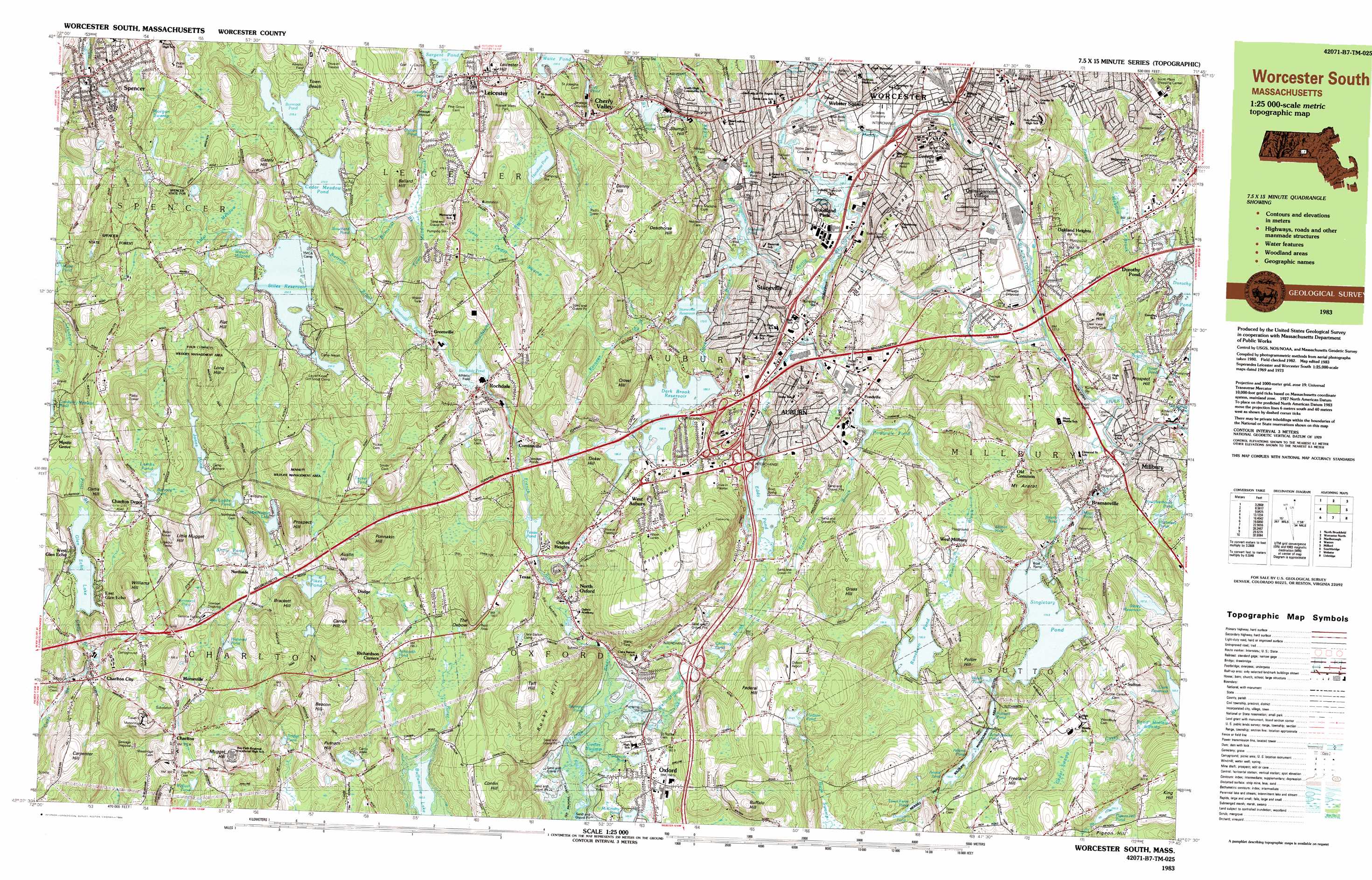
USGS Topo Quad 42071b7 - 1:25,000 scale
| Topo Map Name: | Worcester South |
| USGS Topo Quad ID: | 42071b7 |
| Print Size: | ca. 39" wide x 24" high |
| Southeast Coordinates: | 42.125° N latitude / 71.75° W longitude |
| Map Center Coordinates: | 42.1875° N latitude / 71.875° W longitude |
| U.S. State: | MA |
| Filename: | k42071b7.jpg |
| Download Map JPG Image: | Worcester South topo map 1:25,000 scale |
| Map Type: | Topographic |
| Topo Series: | 7.5´x15´ |
| Map Scale: | 1:25,000 |
| Source of Map Images: | United States Geological Survey (USGS) |
| Alternate Map Versions: |
Worcester South MA 1983, updated 1984 Download PDF Buy paper map Worcester South MA 1983, updated 1984 Download PDF Buy paper map |
1:24,000 Topo Quads surrounding Worcester South
Barre |
Sterling |
Hudson |
||
North Brookfield |
Worcester North |
Marlborough |
||
East Brookfield |
Worcester South |
Milford |
||
Southbridge |
Oxford |
Blackstone |
||
Eastford |
Putnam |
Thompson |
Chepachet |
Georgiaville |
> Back to 42071a1 at 1:100,000 scale
> Back to 42070a1 at 1:250,000 scale
> Back to U.S. Topo Maps home
Worcester South topo map: Gazetteer
Worcester South: Airports
Millbury Savings - West Heliport elevation 121m 396′Oxford Airport elevation 235m 770′
Oxford Airport Incorporated elevation 189m 620′
Worcester South: Crossings
Interchange Eleven elevation 146m 479′Interchange Nine elevation 157m 515′
Interchange Ten elevation 148m 485′
Interchange Ten elevation 195m 639′
Interchange Twelve elevation 138m 452′
Worcester South: Dams
Arnold Pond Dam elevation 183m 600′Auburn Pond Dam elevation 157m 515′
Brierly Pond Dam elevation 159m 521′
Burncoat Pond Dam elevation 274m 898′
Cedar Meadow Pond Dam elevation 270m 885′
Chimney Pond Dam elevation 164m 538′
Curtis Ponds Dam elevation 142m 465′
Dark Brook Reservoir Dam elevation 190m 623′
Dark Brook Reservoir Dike elevation 190m 623′
Dark Dam elevation 177m 580′
Glen Echo Lake Dam elevation 235m 770′
Greenville Pond Dam elevation 231m 757′
Hudson Pond Dam elevation 224m 734′
Jones Pond Dam elevation 267m 875′
Leesville Pond Dam elevation 146m 479′
Little Nugget Lake Dam elevation 233m 764′
Mayo Mill Number One Pond Dam elevation 158m 518′
Pikes Pond Dam elevation 211m 692′
Pondville Pond Dam elevation 158m 518′
Putnam Pond Dam elevation 201m 659′
Quinsigamond Pond Dam elevation 138m 452′
Ramshorn Pond Dam elevation 192m 629′
Rochdale Pond Dam elevation 232m 761′
Sargent Pond Dam elevation 278m 912′
Singletary Pond Dam elevation 170m 557′
Stiles Reservoir Dam elevation 259m 849′
Stoneville Pond Dam elevation 159m 521′
Upper Stoneville Reservoir Dam elevation 173m 567′
Waite Pond Dam elevation 257m 843′
Worcester South: Forests
Spencer State Forest elevation 260m 853′Worcester South: Lakes
Ashworth Pond elevation 178m 583′Bouchard Pond elevation 265m 869′
Carbuncle Pond elevation 153m 501′
Cider Millpond elevation 254m 833′
Crystal Pond elevation 153m 501′
Dodge Pond elevation 209m 685′
Hammond Pond elevation 279m 915′
Hathaway Pond elevation 157m 515′
Henshaw Pond elevation 240m 787′
Hultered Pond elevation 254m 833′
Jamesville Pond elevation 162m 531′
Shiner Hole elevation 175m 574′
Snows Pond elevation 245m 803′
Stillwater Pond elevation 142m 465′
Stump Hill elevation 226m 741′
Stumpy Pond elevation 153m 501′
Tucker Pond elevation 254m 833′
Welsh Pond elevation 174m 570′
Worcester South: Parks
Apricot Street Playground elevation 203m 666′Bennett Field elevation 193m 633′
Boyce Street Park elevation 159m 521′
Cookson Field elevation 200m 656′
Crompton Park elevation 138m 452′
Crystal Street Historic District elevation 151m 495′
Euclid Avenue-Montrose Street Historic District elevation 183m 600′
Fitton elevation 140m 459′
Freegrace Marble Farm Historic District elevation 188m 616′
Gaskin Field elevation 179m 587′
Greenwood Park elevation 152m 498′
Hadwen Park elevation 167m 547′
Mernill Pond State Reservation elevation 182m 597′
Middle River Park elevation 137m 449′
Northside Village Historic District elevation 243m 797′
Oakland Heights Playground elevation 173m 567′
Russell Memorial Park elevation 262m 859′
South Worcester Playground elevation 144m 472′
Spencer Town Center Historic District elevation 273m 895′
Ty Cobb Park elevation 163m 534′
Vernon Hill Playground elevation 182m 597′
View Street Historic District elevation 181m 593′
Woodford Street Historic District elevation 180m 590′
Worcester South: Populated Places
Auburn elevation 187m 613′Bramanville elevation 140m 459′
Cambridge elevation 153m 501′
Camp Barton elevation 205m 672′
Camp Bement elevation 276m 905′
Camp Neyati elevation 263m 862′
Charlton elevation 271m 889′
Charlton City elevation 216m 708′
Charlton Depot elevation 272m 892′
Cherry Valley elevation 219m 718′
College Hill elevation 200m 656′
Cominsville elevation 202m 662′
Dodge elevation 213m 698′
Dorothy Manor elevation 125m 410′
Dorothy Pond elevation 129m 423′
Drury Square elevation 151m 495′
Glen Grove elevation 242m 793′
Glen Grove Annex elevation 246m 807′
Glen Heights elevation 235m 770′
Greenville elevation 233m 764′
Heard Street elevation 184m 603′
Island elevation 138m 452′
Jamesville elevation 175m 574′
Jamesville (historical) elevation 164m 538′
Leicester elevation 298m 977′
Ludlow elevation 166m 544′
Marions Camp elevation 186m 610′
Massasoit elevation 182m 597′
Millbury elevation 123m 403′
Morseville elevation 274m 898′
New Worcester (historical) elevation 159m 521′
North Oxford elevation 160m 524′
Northside elevation 242m 793′
Oakland Heights elevation 170m 557′
Old Common elevation 196m 643′
Oxford Heights elevation 190m 623′
Pakachoag elevation 202m 662′
Pondville elevation 162m 531′
Quinsigamond Village elevation 153m 501′
Rice Square elevation 188m 616′
Richardson Corners elevation 193m 633′
Rochdale elevation 221m 725′
South Grafton Street elevation 135m 442′
South Worcester elevation 147m 482′
Spencer elevation 259m 849′
Stoneville elevation 170m 557′
Sunderland elevation 155m 508′
Sutton elevation 212m 695′
Texas elevation 193m 633′
Trowbridgeville (historical) elevation 152m 498′
Valley Falls (historical) elevation 189m 620′
Vernon Hill elevation 168m 551′
Webster Square elevation 141m 462′
West Auburn elevation 189m 620′
West Millbury elevation 196m 643′
Whispering Pines Estates Mobile Home Park elevation 131m 429′
Windbrook Acres Mobile Home Park elevation 142m 465′
Woodland Park elevation 164m 538′
Worcester South: Post Offices
Leicester Post Office elevation 279m 915′Millbury Post Office elevation 130m 426′
Rochdale Post Office elevation 224m 734′
Worcester South: Reservoirs
Ashwith Pond elevation 269m 882′Auburn Pond elevation 155m 508′
Brierly Pond elevation 158m 518′
Bugs Swamp elevation 195m 639′
Burncoat Pond elevation 274m 898′
Cedar Meadow Pond elevation 270m 885′
Chimney Pond elevation 164m 538′
City Pond elevation 234m 767′
Clarks Mill Pond elevation 233m 764′
Curtis Ponds elevation 142m 465′
Dark Brook elevation 190m 623′
Dutton Pond elevation 258m 846′
Eddy Pond elevation 177m 580′
Glen Echo Lake elevation 235m 770′
Greenville Pond elevation 231m 757′
Hopeville Pond elevation 141m 462′
Howe Pond elevation 116m 380′
Howe Reservoirs elevation 124m 406′
Hudson Pond elevation 224m 734′
Jones Pond elevation 267m 875′
Lambs Pond elevation 277m 908′
Leesville Pond elevation 146m 479′
Little Nugget Lake elevation 232m 761′
Mayo Pond elevation 152m 498′
McKinstry Pond elevation 150m 492′
Pikes Pond elevation 211m 692′
Pondville Pond elevation 158m 518′
Putnam Pond elevation 201m 659′
Quinsigamond Pond elevation 138m 452′
Railroad Pond elevation 272m 892′
Ramshorn Pond elevation 192m 629′
Rochdale Pond elevation 232m 761′
Sargent Pond elevation 278m 912′
Sibley Reservoir elevation 167m 547′
Sigourney Pond elevation 161m 528′
Singletary Pond elevation 173m 567′
Slaughterhouse Pond elevation 157m 515′
Smiths Pond elevation 228m 748′
Stiles Reservoir elevation 259m 849′
Stoneville Pond elevation 159m 521′
Stoneville Reservoir elevation 173m 567′
Texas Pond elevation 180m 590′
Wabash Pond elevation 251m 823′
Waite Pond elevation 257m 843′
Watson Millpond elevation 266m 872′
Wee Laddie Pond elevation 245m 803′
Worcester South: Streams
Bartons Brook elevation 231m 757′Beaver Brook elevation 141m 462′
Broad Meadow Brook elevation 119m 390′
Burncoat Brook elevation 246m 807′
Casey Brook elevation 158m 518′
Chapin Brook elevation 174m 570′
Dark Brook elevation 158m 518′
Dark Brook elevation 153m 501′
Dorothy Brook elevation 108m 354′
Grindstone Brook elevation 219m 718′
Kettle Brook elevation 144m 472′
Kinnear Brook elevation 186m 610′
Lynde Brook elevation 222m 728′
Middle River elevation 134m 439′
Mill Brook elevation 137m 449′
Pratt Brook elevation 137m 449′
Pratt Brook elevation 236m 774′
Ramshorn Brook elevation 196m 643′
Singletary Brook elevation 117m 383′
Stone Brook elevation 158m 518′
Stoneville Brook elevation 158m 518′
Tatnuck Brook elevation 141m 462′
Town Meadow Brook elevation 231m 757′
Wellington Brook elevation 153m 501′
Worcester South: Summits
Austin Hill elevation 248m 813′Ballard Hill elevation 300m 984′
Beacon Hill elevation 263m 862′
Brackett Hill elevation 265m 869′
Buffalo Hill elevation 230m 754′
Carpenter Hill elevation 261m 856′
Carroll Hill elevation 262m 859′
Conlin Hill elevation 225m 738′
Crowl Hill elevation 262m 859′
Curtis Hill elevation 294m 964′
Deadhorse Hill elevation 253m 830′
Denny Hill elevation 289m 948′
Dorothy Hill elevation 214m 702′
Federal Hill elevation 244m 800′
Flat Hill elevation 324m 1062′
Freeland Hill elevation 229m 751′
Gately Hill elevation 313m 1026′
Grass Hill elevation 228m 748′
Leicester Hill elevation 310m 1017′
Little Mugget Hill elevation 328m 1076′
Long Hill elevation 327m 1072′
Mount Ararat elevation 222m 728′
Mount Pleasant elevation 310m 1017′
Mugget Hill elevation 299m 980′
Pakachoag Hill elevation 138m 452′
Park Hill elevation 192m 629′
Pigeon Hill elevation 225m 738′
Ponnakin Hill elevation 276m 905′
Potter Hill elevation 240m 787′
Prospect Hill elevation 287m 941′
Prospect Hill elevation 226m 741′
Prospect Hill elevation 150m 492′
Putnam Hill elevation 247m 810′
Rocky Hill elevation 197m 646′
Taft Hill elevation 256m 839′
Tinker Hill elevation 214m 702′
Union Hill elevation 218m 715′
Williams Hill elevation 304m 997′
Worcester South: Swamps
Alder Meadow elevation 272m 892′Bond Hollow Swamp elevation 161m 528′
Cedar Swamp elevation 191m 626′
Cedar Swamp elevation 153m 501′
Great Cedar Swamp elevation 242m 793′
Morgan Swamp elevation 290m 951′
Worcester South digital topo map on disk
Buy this Worcester South topo map showing relief, roads, GPS coordinates and other geographical features, as a high-resolution digital map file on DVD:
Maine, New Hampshire, Rhode Island & Eastern Massachusetts
Buy digital topo maps: Maine, New Hampshire, Rhode Island & Eastern Massachusetts