Reading Topo Map Massachusetts
To zoom in, hover over the map of Reading
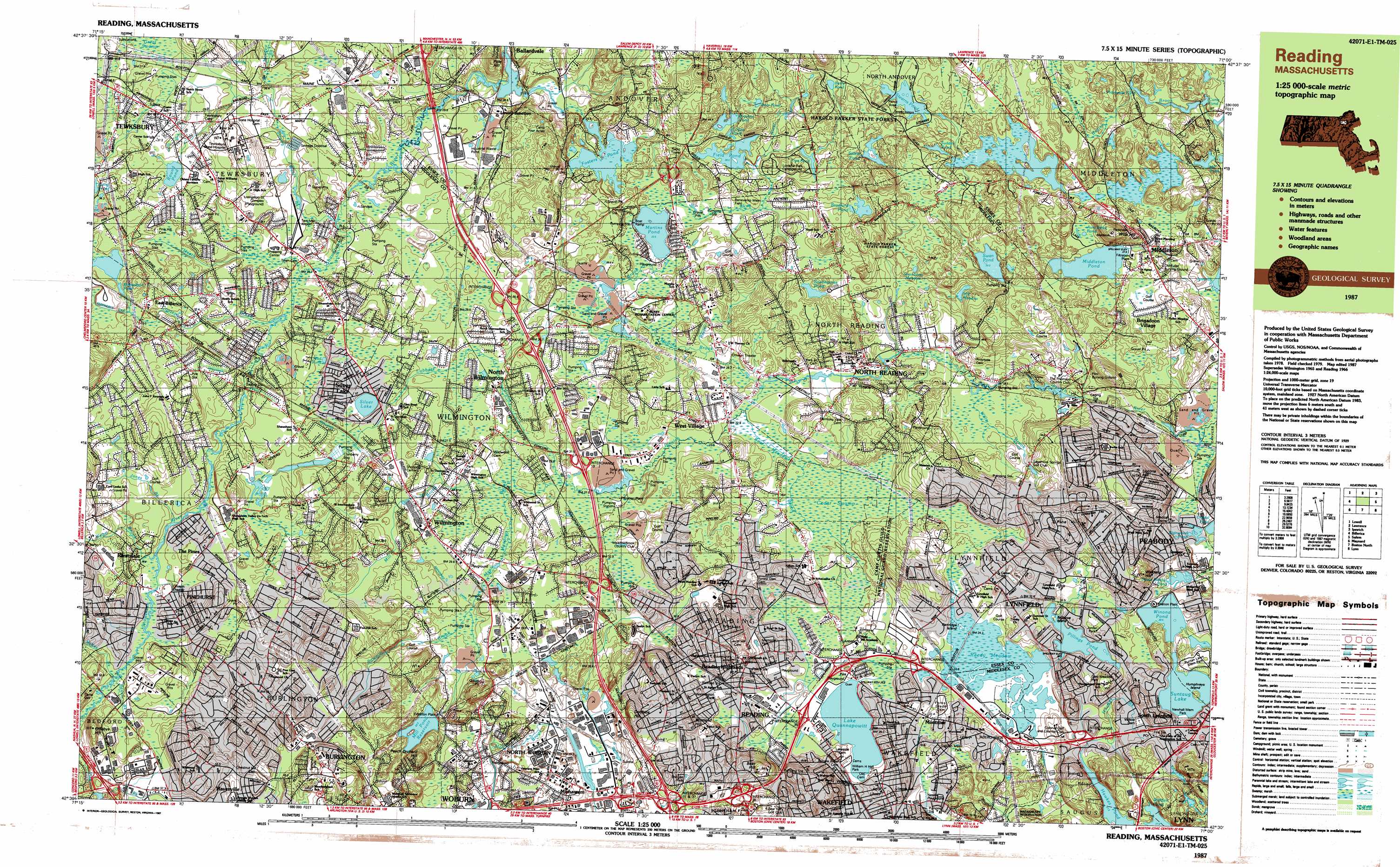
USGS Topo Quad 42071e1 - 1:25,000 scale
| Topo Map Name: | Reading |
| USGS Topo Quad ID: | 42071e1 |
| Print Size: | ca. 39" wide x 24" high |
| Southeast Coordinates: | 42.5° N latitude / 71° W longitude |
| Map Center Coordinates: | 42.5625° N latitude / 71.125° W longitude |
| U.S. State: | MA |
| Filename: | k42071e1.jpg |
| Download Map JPG Image: | Reading topo map 1:25,000 scale |
| Map Type: | Topographic |
| Topo Series: | 7.5´x15´ |
| Map Scale: | 1:25,000 |
| Source of Map Images: | United States Geological Survey (USGS) |
| Alternate Map Versions: |
Reading MA 1987, updated 1987 Download PDF Buy paper map Reading MA 1987, updated 1987 Download PDF Buy paper map |
1:24,000 Topo Quads surrounding Reading
Windham |
Haverhill |
Newburyport East |
||
Lowell |
South Groveland |
Ipswich |
||
Billerica |
Reading |
Salem |
||
Concord |
Boston North |
Marblehead South |
||
Natick |
Boston South |
Nantasket Beach |
> Back to 42071e1 at 1:100,000 scale
> Back to 42070a1 at 1:250,000 scale
> Back to U.S. Topo Maps home
Reading topo map: Gazetteer
Reading: Airports
Digital Heliport elevation 16m 52′Tew-Mac Airport elevation 27m 88′
Reading: Beaches
Silver Lake Town Beach elevation 28m 91′Reading: Crossings
Interchange eleven and thirty-seven elevation 30m 98′Interchange Fifteen elevation 52m 170′
Interchange Fourteen elevation 29m 95′
Interchange Thirteen elevation 30m 98′
Interchange Thirty Two elevation 25m 82′
Interchange Thirty-five elevation 26m 85′
Interchange Thirty-four elevation 26m 85′
Interchange Thirty-Nine elevation 31m 101′
Interchange Thirty-one elevation 30m 98′
Interchange Thirty-three elevation 21m 68′
Interchange Twelve elevation 28m 91′
Interchange Twenty-Six elevation 43m 141′
Reading: Dams
Boston Brook Dam elevation 16m 52′Brackett Pond Dam elevation 31m 101′
Devils Dishfull Pond Dam elevation 26m 85′
Elginwood Pond Dam elevation 14m 45′
Emerson Brook Lake Street Dam elevation 26m 85′
Field Pond Dam elevation 23m 75′
Fosters Pond Dam elevation 25m 82′
Hawkes Pond Outlet Dam elevation 21m 68′
Ipswich River Dam elevation 17m 55′
Lake Quannapowitt Dam elevation 25m 82′
Lynn Waterways Dam elevation 25m 82′
Martins Pond Dam elevation 22m 72′
Middleton Pond Outlet Dam elevation 28m 91′
Mill Pond Main Dam elevation 36m 118′
Mill Pond North Dike elevation 59m 193′
Mill Pond South Dike elevation 35m 114′
Pillings Pond Dam elevation 33m 108′
Stearns Pond East Dam elevation 34m 111′
Suntaug Lake Dam elevation 30m 98′
Winona Pond Dam elevation 30m 98′
Reading: Islands
Humphreys Island elevation 36m 118′Monk Island elevation 25m 82′
Reading: Lakes
Aunt Betts Pond elevation 29m 95′Bear Pond elevation 41m 134′
Berry Pond elevation 41m 134′
Bradford Pond elevation 38m 124′
Collins Pond elevation 29m 95′
Crystal Pond elevation 20m 65′
Elginwood Pond elevation 17m 55′
Frye Pond elevation 28m 91′
Middleton Pond elevation 28m 91′
Mud Pond elevation 29m 95′
Pillings Pond elevation 33m 108′
Pomps Pond elevation 32m 104′
Richardson Pond elevation 32m 104′
Round Pond elevation 34m 111′
Salem Pond elevation 37m 121′
Sawmill Pond (historical) elevation 38m 124′
Spectacle Ponds elevation 55m 180′
Stearns Pond elevation 34m 111′
Sudden Pond elevation 29m 95′
Suntaug Lake elevation 30m 98′
Swan Pond elevation 33m 108′
Tannery Pond elevation 47m 154′
Reading: Parks
Ackerson Playground elevation 31m 101′Benevento Memorial Field elevation 23m 75′
Burlington Town Common elevation 67m 219′
Camp Oak elevation 40m 131′
Church-Lafayette Streets Historic District elevation 26m 85′
Common District elevation 30m 98′
Common Historic District elevation 47m 154′
Livingston Street Complex elevation 31m 101′
Rahanis Park elevation 41m 134′
Simonds Park elevation 67m 219′
Sullivan Memorial Park elevation 24m 78′
Veterans Field elevation 25m 82′
Veterans Memorial Park elevation 38m 124′
Wakefield Park elevation 42m 137′
Wilmington Town Common elevation 29m 95′
Woburn Street Historic District elevation 41m 134′
Yale Avenue Historic District elevation 31m 101′
Reading: Populated Places
Brigadoon Village elevation 26m 85′Burlington elevation 67m 219′
Burtts Crossing elevation 25m 82′
East Billerica elevation 37m 121′
Fox Hill elevation 47m 154′
Havenville elevation 49m 160′
Lowell Junction elevation 24m 78′
Lynnfield elevation 27m 88′
Middleton elevation 31m 101′
Mishawum elevation 26m 85′
Montrose elevation 29m 95′
North Reading elevation 30m 98′
North Wilmington elevation 26m 85′
North Woburn elevation 33m 108′
Pattenville elevation 30m 98′
Pinehurst elevation 32m 104′
Reading elevation 28m 91′
Reading Highlands elevation 44m 144′
Silver Lake elevation 34m 111′
South Lynnfield elevation 44m 144′
South Middleton elevation 23m 75′
South Wilmington elevation 33m 108′
Tewksbury elevation 37m 121′
Tewksbury Junction elevation 31m 101′
The Pines elevation 29m 95′
Wakefield elevation 31m 101′
West Village elevation 25m 82′
Wilmington elevation 27m 88′
Wilmington Junction elevation 28m 91′
Reading: Post Offices
Burlington Post Office elevation 71m 232′Lynnfield Post Office (historical) elevation 41m 134′
Middleton Post Office (historical) elevation 24m 78′
Post Office Square Shopping Center elevation 39m 127′
Reading Post Office elevation 39m 127′
Shawsheen Post Office elevation 32m 104′
Tewksbury Post Office elevation 29m 95′
Wakefield Post Office elevation 34m 111′
Wilmington Post Office elevation 26m 85′
Reading: Reservoirs
Brackett Pond elevation 31m 101′College Pond elevation 37m 121′
Devils Dishfull Pond elevation 26m 85′
Emerson Brook Reservoir elevation 26m 85′
Field Pond elevation 23m 75′
Fosters Pond elevation 25m 82′
Furbish Pond elevation 23m 75′
Ipswich River Reservoir elevation 17m 55′
Lake Quannapowitt elevation 25m 82′
Martins Pond elevation 22m 72′
Mill Pond elevation 35m 114′
Mill Pond elevation 14m 45′
Mishawum Lake elevation 17m 55′
Patches Pond elevation 25m 82′
Richardsons Pond elevation 34m 111′
Winona Pond elevation 30m 98′
Reading: Ridges
Bow Ridge elevation 76m 249′Reading: Streams
Bear Meadow Brook elevation 31m 101′Beaver Brook elevation 30m 98′
Beaverdam Brook elevation 22m 72′
Content Brook elevation 26m 85′
Flint Brook elevation 16m 52′
Halls Brook elevation 17m 55′
Heath Brook elevation 24m 78′
Jones Brook elevation 26m 85′
Lubbers Brook elevation 23m 75′
Maple Meadow Brook elevation 23m 75′
Martins Brook elevation 20m 65′
McKee Brook elevation 29m 95′
Meadow Brook elevation 30m 98′
Mill Brook elevation 23m 75′
Rapers Brook elevation 32m 104′
Skug River elevation 22m 72′
Strong Water Brook elevation 26m 85′
Willow Brook elevation 30m 98′
Wills Brook elevation 18m 59′
Reading: Summits
Aslebe Hill elevation 77m 252′Bear Hill elevation 67m 219′
Cowdry Hill elevation 56m 183′
Crosbys Hill elevation 64m 209′
Dobbins Hill elevation 69m 226′
Huckleberry Hill elevation 52m 170′
Long Woods Hills elevation 48m 157′
Peach Orchard Hill elevation 77m 252′
Pine Hill elevation 65m 213′
Pine Hill elevation 37m 121′
Pole Hill elevation 64m 209′
Rattlesnake Hill elevation 55m 180′
Scotland Hill elevation 58m 190′
Snake Hill elevation 37m 121′
Uptons Hill elevation 71m 232′
Waldens Hill elevation 71m 232′
Wills Hill elevation 73m 239′
Wood Hill elevation 61m 200′
Reading: Swamps
Cedar Swamp elevation 26m 85′Hundred Acre Meadow elevation 23m 75′
Mill Meadow elevation 34m 111′
Strawberry Meadow elevation 23m 75′
Reading digital topo map on disk
Buy this Reading topo map showing relief, roads, GPS coordinates and other geographical features, as a high-resolution digital map file on DVD:
Maine, New Hampshire, Rhode Island & Eastern Massachusetts
Buy digital topo maps: Maine, New Hampshire, Rhode Island & Eastern Massachusetts