Fitchburg Topo Map Massachusetts
To zoom in, hover over the map of Fitchburg
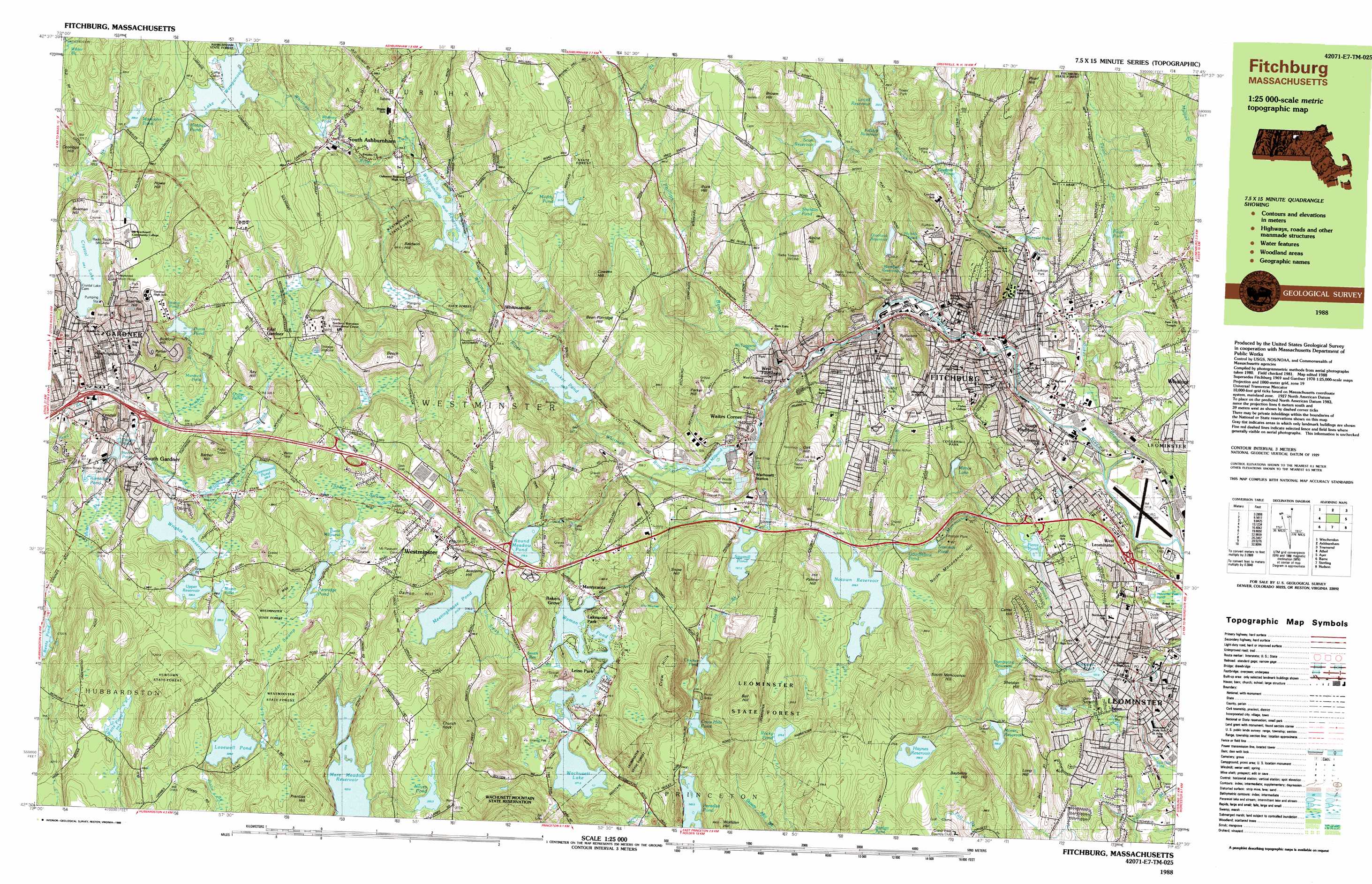
USGS Topo Quad 42071e7 - 1:25,000 scale
| Topo Map Name: | Fitchburg |
| USGS Topo Quad ID: | 42071e7 |
| Print Size: | ca. 39" wide x 24" high |
| Southeast Coordinates: | 42.5° N latitude / 71.75° W longitude |
| Map Center Coordinates: | 42.5625° N latitude / 71.875° W longitude |
| U.S. State: | MA |
| Filename: | k42071e7.jpg |
| Download Map JPG Image: | Fitchburg topo map 1:25,000 scale |
| Map Type: | Topographic |
| Topo Series: | 7.5´x15´ |
| Map Scale: | 1:25,000 |
| Source of Map Images: | United States Geological Survey (USGS) |
| Alternate Map Versions: |
Fitchburg MA 1988, updated 1988 Download PDF Buy paper map |
1:24,000 Topo Quads surrounding Fitchburg
Monadnock Mountain |
Peterborough South |
Greenville |
Milford |
South Merrimack |
Winchendon |
Ashby |
Pepperell |
||
Templeton |
Fitchburg |
Ayer |
||
Barre |
Sterling |
Hudson |
||
North Brookfield |
Worcester North |
Marlborough |
> Back to 42071e1 at 1:100,000 scale
> Back to 42070a1 at 1:250,000 scale
> Back to U.S. Topo Maps home
Fitchburg topo map: Gazetteer
Fitchburg: Airports
Digital Heliport elevation 337m 1105′Fitchburg Municipal Airport elevation 101m 331′
Fitchburg Paper Company Heliport elevation 168m 551′
Fitchburg-Leominster Airport elevation 100m 328′
Leominster Hospital Heliport elevation 133m 436′
Lleia Kyle O'Meara Heliport elevation 371m 1217′
Long Hill Heliport elevation 196m 643′
Fitchburg: Dams
Arden Mill Dam elevation 116m 380′Bents Pond Dam elevation 309m 1013′
Bents Pond Dam elevation 313m 1026′
Burnt Millpond Dam elevation 341m 1118′
Cowee Pond Dam elevation 323m 1059′
Crocker Pond Dam elevation 223m 731′
Crocker Pond Dam elevation 243m 797′
Crystal Lake Dike elevation 322m 1056′
Duck Mill Dam elevation 115m 377′
Dunn Pond Dam elevation 332m 1089′
Ellis Pond Dam elevation 335m 1099′
Goodfellow Pond Dam elevation 215m 705′
Greenes Pond Dam elevation 160m 524′
Haynes Reservoir Dam elevation 254m 833′
James Pond Dam elevation 196m 643′
Lake Wampanoag Dam elevation 326m 1069′
Lovell Reservoir Dam elevation 212m 695′
Lovell Reservoir Dike elevation 232m 761′
Lovewell Pond Dam elevation 328m 1076′
McTaggarts Pond Dam elevation 195m 639′
Meetinghouse Pond Dam elevation 314m 1030′
Mill Pond Dam Number 1 elevation 168m 551′
Minott Pond Dam elevation 328m 1076′
Morse Reservoir Dam elevation 205m 672′
North Nashua River Dam elevation 181m 593′
Notown Reservoir Dam elevation 224m 734′
Notown Reservoir Dike elevation 224m 734′
Noyes Pond Dam elevation 355m 1164′
Overlook Reservoir Dam elevation 254m 833′
Overlook Reservoir Dam elevation 238m 780′
Overlook Reservoir Dike elevation 254m 833′
Pierce Pond Dam elevation 143m 469′
Pierce Pond Dam elevation 333m 1092′
Rockwell Pond Dam elevation 129m 423′
Round Meadow Pond Dam elevation 278m 912′
Sawmill Pond Dam elevation 201m 659′
Scott Reservoir Dam elevation 267m 875′
Simonds Pond Dam elevation 275m 902′
Snows Mill Pond Dam elevation 202m 662′
Upper Crow Hills Pond Dam elevation 261m 856′
Upper Reservoir Dam elevation 327m 1072′
Wachusett Reservoir Dam elevation 281m 921′
Waite Pond Dam elevation 315m 1033′
Westminster Reservoir Dam elevation 246m 807′
Wrights Reservoir Dam elevation 332m 1089′
Wyman Pond Dam elevation 275m 902′
Fitchburg: Flats
Rice Meadow elevation 257m 843′Fitchburg: Forests
Leominster State Forest elevation 302m 990′Fitchburg: Islands
Redemption Rock elevation 280m 918′Fitchburg: Lakes
Baker Pond elevation 111m 364′Muddy Pond elevation 317m 1040′
Nichols Pond elevation 213m 698′
Paradise Pond elevation 245m 803′
Quag Pond elevation 334m 1095′
Rice Meadow Pond elevation 251m 823′
Rocky Pond elevation 273m 895′
Saima Pond elevation 168m 551′
Sheldon Pond elevation 286m 938′
Shiner Pond elevation 304m 997′
Stump Pond elevation 336m 1102′
Whitney Pond elevation 304m 997′
Fitchburg: Parks
Bickford Playground elevation 311m 1020′Caldwell Park elevation 176m 577′
Chapman Park elevation 331m 1085′
Coolidge Park elevation 126m 413′
Crocker Field elevation 141m 462′
Crow Hill State Reservation elevation 264m 866′
Crystal Lake Park elevation 343m 1125′
Dunn Park elevation 342m 1122′
Falulah Park elevation 190m 623′
Forrester elevation 271m 889′
Fournier Park elevation 132m 433′
Greenwood Street Playground elevation 325m 1066′
Haeger Park elevation 300m 984′
Jackson Field elevation 354m 1161′
Lowe Playground elevation 150m 492′
Marilene Stedman Playground elevation 359m 1177′
Monument Square Historic District elevation 123m 403′
Morgan Playground elevation 197m 646′
South Fitchburg Playground elevation 127m 416′
West Gardner Square Historic District elevation 325m 1066′
Westminster State Forest elevation 353m 1158′
Westminster Village-Academy Hill Historic District elevation 324m 1062′
Fitchburg: Populated Places
Bakers Grove elevation 275m 902′Camp Collier elevation 328m 1076′
East Gardner elevation 361m 1184′
Fitchburg elevation 142m 465′
Gardner elevation 325m 1066′
Lakewood Park elevation 274m 898′
Leino Park elevation 271m 889′
Leominster elevation 122m 400′
Mantyranta elevation 284m 931′
Meadowbrook Acres Mobile Home Park elevation 118m 387′
Olde English Village elevation 303m 994′
South Ashburnham elevation 294m 964′
South Fitchburg elevation 138m 452′
South Gardner elevation 319m 1046′
Wachusett elevation 245m 803′
Wachusett Station elevation 195m 639′
Waites Corner elevation 212m 695′
West Fitchburg elevation 197m 646′
West Leominster elevation 137m 449′
Westminster elevation 325m 1066′
Whitmanville elevation 241m 790′
Fitchburg: Post Offices
Fitchburg Post Office elevation 151m 495′Gardner Post Office elevation 325m 1066′
Leominster Post Office elevation 124m 406′
South Westminster Post Office (historical) elevation 330m 1082′
Twin City Plaza Post Office elevation 147m 482′
Westminster Depot Post Office (historical) elevation 223m 731′
Fitchburg: Reservoirs
Barrett Pond elevation 139m 456′Bents Pond elevation 313m 1026′
Burnt Millpond elevation 341m 1118′
Colburns Reservoir elevation 142m 465′
Cowee Pond elevation 323m 1059′
Crocker Pond elevation 243m 797′
Crocker Pond elevation 223m 731′
Crow Hills Pond elevation 253m 830′
Crystal Lake elevation 322m 1056′
Distributing Reservoir elevation 178m 583′
Dunn Pond elevation 332m 1089′
Falulah Reservoir elevation 211m 692′
Goodfellow Pond elevation 217m 711′
Greenes Pond elevation 160m 524′
Greenwood Pond elevation 333m 1092′
Haynes Reservoir elevation 254m 833′
Hobbys Pond elevation 331m 1085′
James Pond elevation 196m 643′
Lake Wampanoag elevation 326m 1069′
Lovell Reservoir elevation 212m 695′
Lovewell Pond elevation 328m 1076′
Marshall Reservoir elevation 173m 567′
McTaggards Pond elevation 202m 662′
Meetinghouse Pond elevation 314m 1030′
Minott Pond elevation 328m 1076′
Mirror Lake elevation 195m 639′
Morse Reservoir elevation 211m 692′
Murdock Pond elevation 319m 1046′
North Nashua River Reservoir elevation 168m 551′
North Nashua River Reservoir elevation 116m 380′
North Nashua River Reservoir elevation 181m 593′
North Nashua River Reservoir elevation 115m 377′
Notown Reservoir elevation 224m 734′
Noyes Pond elevation 355m 1164′
Overlook Reservoir elevation 254m 833′
Partridge Pond elevation 335m 1099′
Pierce Pond elevation 143m 469′
Putnam Pond elevation 137m 449′
Ramsdall Pond elevation 304m 997′
Rockwell Pond elevation 129m 423′
Round Meadow Pond elevation 278m 912′
Sawmill Pond elevation 201m 659′
Scott Reservoir elevation 269m 882′
Simonds Pond elevation 275m 902′
Smith Pond elevation 135m 442′
Smith Reservoir elevation 278m 912′
Snows Millpond elevation 202m 662′
Sumond Pond elevation 211m 692′
Travers Pond elevation 309m 1013′
Upper Reservoir elevation 327m 1072′
Wachusett Lake elevation 281m 921′
Wachusett Lake Reservoir elevation 281m 921′
Waite Pond elevation 315m 1033′
Westminster Reservoir elevation 246m 807′
Whitmanville Reservoir elevation 252m 826′
Wrights Reservoir elevation 332m 1089′
Wyman Pond elevation 271m 889′
Fitchburg: Streams
Baker Brook elevation 101m 331′Baker Brook elevation 306m 1003′
Falulah Brook elevation 114m 374′
Flag Brook elevation 173m 567′
Laws Brook elevation 346m 1135′
Mahoney Brook elevation 313m 1026′
Pearl Hill Brook elevation 114m 374′
Phillips Brook elevation 173m 567′
Sand Brook elevation 151m 495′
Scott Brook elevation 213m 698′
Smith Brook elevation 273m 895′
Whitman River elevation 173m 567′
Fitchburg: Summits
Academy Hill elevation 347m 1138′Alpine Hill elevation 318m 1043′
Baldwin Hill elevation 322m 1056′
Ball Hill elevation 364m 1194′
Barber Hill elevation 370m 1213′
Bayberry Hill elevation 240m 787′
Beaman Hill elevation 351m 1151′
Bean Porridge Hill elevation 325m 1066′
Beech Hill elevation 349m 1145′
Bickford Hill elevation 385m 1263′
Brown Hill elevation 368m 1207′
Buck Hill elevation 321m 1053′
Carter Hill elevation 218m 715′
Church Rock elevation 392m 1286′
Coolidge Hill elevation 356m 1167′
Cowees Hill elevation 344m 1128′
Crow Hills elevation 277m 908′
Damon Hill elevation 350m 1148′
Howe Hill elevation 383m 1256′
Kendall Hill elevation 346m 1135′
Long Hill elevation 260m 853′
Monoosnoc Hills elevation 177m 580′
Mount Elam elevation 262m 859′
North Monoosnoc Hill elevation 295m 967′
Oak Hill elevation 292m 958′
Palmer Hill elevation 274m 898′
Parker Hill elevation 383m 1256′
Parker Hill elevation 299m 980′
Pine Hill elevation 262m 859′
Pine Hill elevation 234m 767′
Prentiss Hill elevation 386m 1266′
Prospect Hill elevation 342m 1122′
Prospect Hill elevation 343m 1125′
Ray Hill elevation 367m 1204′
Reservoir Hill elevation 392m 1286′
Rollstone Hill elevation 247m 810′
Sheldon Hill elevation 225m 738′
Snow Hill elevation 308m 1010′
South Monoosnoc Hill elevation 351m 1151′
Washington Hill elevation 356m 1167′
Wolfden Hill elevation 303m 994′
Fitchburg: Swamps
Cedar Swamp elevation 339m 1112′Tophet Swamp elevation 331m 1085′
Fitchburg digital topo map on disk
Buy this Fitchburg topo map showing relief, roads, GPS coordinates and other geographical features, as a high-resolution digital map file on DVD:
Maine, New Hampshire, Rhode Island & Eastern Massachusetts
Buy digital topo maps: Maine, New Hampshire, Rhode Island & Eastern Massachusetts