Ashby Topo Map Massachusetts
To zoom in, hover over the map of Ashby
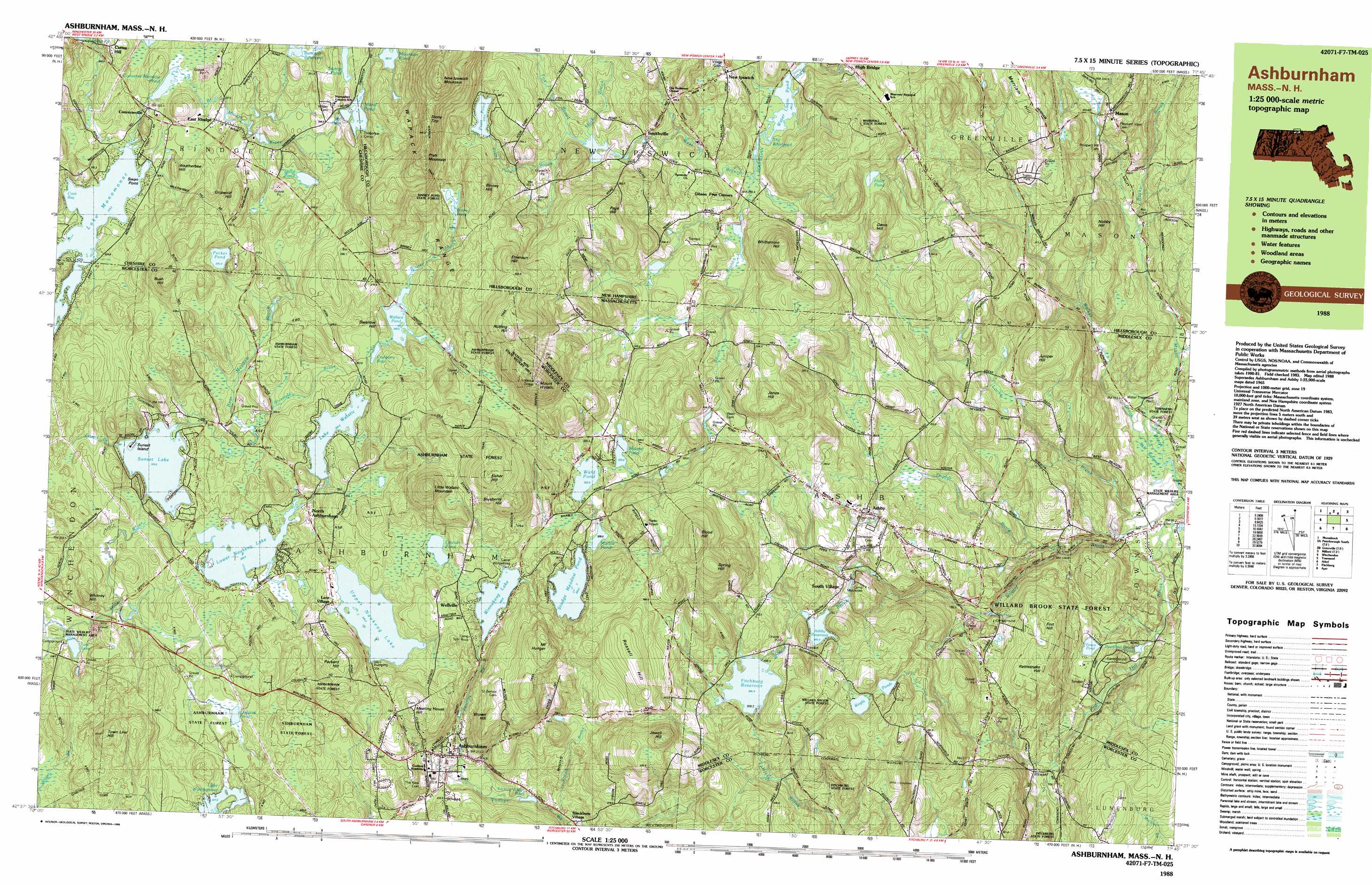
USGS Topo Quad 42071f7 - 1:25,000 scale
| Topo Map Name: | Ashby |
| USGS Topo Quad ID: | 42071f7 |
| Print Size: | ca. 39" wide x 24" high |
| Southeast Coordinates: | 42.625° N latitude / 71.75° W longitude |
| Map Center Coordinates: | 42.6875° N latitude / 71.875° W longitude |
| U.S. States: | MA, NH |
| Filename: | k42071f7.jpg |
| Download Map JPG Image: | Ashby topo map 1:25,000 scale |
| Map Type: | Topographic |
| Topo Series: | 7.5´x15´ |
| Map Scale: | 1:25,000 |
| Source of Map Images: | United States Geological Survey (USGS) |
| Alternate Map Versions: |
Ashburnham MA 1988, updated 1988 Download PDF Buy paper map |
1:24,000 Topo Quads surrounding Ashby
Dublin |
Peterborough North |
Greenfield |
New Boston |
Pinardville |
Monadnock Mountain |
Peterborough South |
Greenville |
Milford |
South Merrimack |
Winchendon |
Ashby |
Pepperell |
||
Templeton |
Fitchburg |
Ayer |
||
Barre |
Sterling |
Hudson |
> Back to 42071e1 at 1:100,000 scale
> Back to 42070a1 at 1:250,000 scale
> Back to U.S. Topo Maps home
Ashby topo map: Gazetteer
Ashby: Bays
Coot Bay elevation 318m 1043′Ashby: Capes
Swan Point elevation 320m 1049′Ashby: Dams
Ashby Reservoir Dam elevation 278m 912′Bancroft Reservoir Dam elevation 356m 1167′
Factory Village Pond Dam elevation 274m 898′
Fitchburg Reservoir North Dam elevation 300m 984′
Fitchburg Reservoir South Dam elevation 306m 1003′
Fitchburg Reservoir South Dike elevation 306m 1003′
Lake Watatic Dam elevation 343m 1125′
Lower Naukeag Lake Dam elevation 326m 1069′
Marble Pond Dam elevation 339m 1112′
Mill Pond Dam elevation 375m 1230′
Mountain Pond Dam elevation 383m 1256′
Pratt Pond Dam elevation 376m 1233′
Souhegan River Watershed Dam Number 19 elevation 303m 994′
Souhegan River Watershed Dam Number 35 elevation 328m 1076′
Stodge Meadow Pond Dam elevation 342m 1122′
Stump Pond Dam elevation 383m 1256′
Sunset Lake Dam elevation 326m 1069′
Upper Naukeag Lake Dam elevation 341m 1118′
Winnekeag Lake Dam elevation 361m 1184′
Ashby: Forests
Ashburnham State Forest elevation 363m 1190′Fitchburg State Forest elevation 172m 564′
Willard Brook State Forest elevation 167m 547′
Ashby: Lakes
Bancroft Reservoir elevation 382m 1253′Binney Pond elevation 394m 1292′
Cheshire Pond elevation 326m 1069′
Converse Meadow Pond elevation 331m 1085′
Divol Pond elevation 359m 1177′
Gibson Pond elevation 289m 948′
Hoar Pond elevation 320m 1049′
Island Pond elevation 372m 1220′
Jeffs Pond elevation 263m 862′
Lake Monomonac elevation 318m 1043′
Lincoln Pond elevation 352m 1154′
Lower Naukeag Lake elevation 326m 1069′
Pearl Hill Brook Pond elevation 119m 390′
Pecker Pond elevation 386m 1266′
Vinton Pond elevation 156m 511′
Wallace Pond elevation 349m 1145′
Ward Pond elevation 333m 1092′
Watatic Pond elevation 334m 1095′
Wright Ponds elevation 299m 980′
Ashby: Parks
Ashby Common elevation 276m 905′Bickford Field elevation 293m 961′
Binney Pond State Forest elevation 394m 1292′
Marshall State Forest elevation 364m 1194′
Pearl Hill State Park elevation 125m 410′
Watatic Mountain State Wildlife Area elevation 557m 1827′
Ashby: Populated Places
Ashburnham elevation 309m 1013′Ashby elevation 279m 915′
Blackburn Village elevation 268m 879′
Converseville elevation 333m 1092′
Cutter Hill elevation 364m 1194′
East Rindge elevation 337m 1105′
Gibson Four Corners elevation 290m 951′
Lane Village elevation 348m 1141′
Mason elevation 228m 748′
New Ipswich elevation 323m 1059′
North Ashburnham elevation 332m 1089′
Old North Ashburnham Station elevation 316m 1036′
Rogersville (historical) elevation 122m 400′
Smithville elevation 323m 1059′
South Village elevation 274m 898′
Wellville elevation 351m 1151′
Ashby: Post Offices
Ashby Post Office elevation 271m 889′Ashby: Ranges
Wapack Range elevation 532m 1745′Ashby: Rapids
The Whirlpool elevation 284m 931′Ashby: Reservoirs
Ashby Reservoir elevation 278m 912′Damon Pond elevation 201m 659′
Factory Village Pond elevation 277m 908′
Fitchburg Reservoir elevation 300m 984′
Lake Watatic elevation 343m 1125′
Lower Wrights Pond elevation 303m 994′
Marble Pond elevation 339m 1112′
Mill Pond elevation 375m 1230′
Mountain Pond elevation 383m 1256′
Pratt Pond elevation 376m 1233′
Smithville Reservoir elevation 328m 1076′
Stodge Meadow Pond elevation 342m 1122′
Stump Pond elevation 382m 1253′
Sunset Lake elevation 326m 1069′
Upper Naukeag Lake elevation 341m 1118′
Upper Wrights Pond elevation 294m 964′
Winnekeag Lake elevation 340m 1115′
Ashby: Streams
Bear Meadow Brook elevation 330m 1082′Bear Meadow Brook elevation 330m 1082′
Binney Hill Brook elevation 350m 1148′
Binney Hill Brook elevation 349m 1145′
Bluefield Brook elevation 330m 1082′
Brown Brook elevation 261m 856′
Estees Brook elevation 326m 1069′
Fox Brook elevation 327m 1072′
Locke Brook elevation 93m 305′
Mason Brook elevation 93m 305′
Mason Brook elevation 93m 305′
Pearl Hill Brook elevation 130m 426′
Pratt Pond Brook elevation 327m 1072′
Rocky Brook elevation 125m 410′
South Branch Souhegan River elevation 283m 928′
Stark Brook elevation 327m 1072′
Trapfall Brook elevation 135m 442′
Walker Brook elevation 93m 305′
Walker Brook elevation 93m 305′
West Branch Souhegan River elevation 283m 928′
West Souhegan River elevation 283m 928′
Whitemans Brook elevation 344m 1128′
Ashby: Summits
Binney Hill elevation 436m 1430′Blood Hill elevation 460m 1509′
Brown Hill elevation 400m 1312′
Bush Hill elevation 431m 1414′
Davis Hill elevation 335m 1099′
Emerson Hill elevation 464m 1522′
Fisher Hill elevation 470m 1541′
Fort Hill elevation 241m 790′
Griswold Hill elevation 417m 1368′
Jewell Hill elevation 429m 1407′
Jones Hill elevation 396m 1299′
Juniper Hill elevation 278m 912′
Little Watatic Mountain elevation 483m 1584′
Meeting House Hill elevation 408m 1338′
Merriam Hill elevation 312m 1023′
Mount Hunger elevation 443m 1453′
Mount Watatic elevation 558m 1830′
New Ipswich Mountain elevation 567m 1860′
Nobby Hill elevation 234m 767′
Nutting Hill elevation 494m 1620′
Packard Hill elevation 409m 1341′
Page Hill elevation 412m 1351′
Pearl Hill elevation 252m 826′
Pratt Mountain elevation 552m 1811′
Rattlesnake Hill elevation 254m 833′
Rocky Hill elevation 382m 1253′
Russell Hill elevation 413m 1354′
Stony Top elevation 533m 1748′
Swallow Hill elevation 374m 1227′
Town Line Hill elevation 411m 1348′
Weatherbee Hill elevation 340m 1115′
Whitney Hill elevation 350m 1148′
Whittemore Hill elevation 416m 1364′
Ashby: Swamps
Ash Swamp elevation 93m 305′Ashby digital topo map on disk
Buy this Ashby topo map showing relief, roads, GPS coordinates and other geographical features, as a high-resolution digital map file on DVD:
Maine, New Hampshire, Rhode Island & Eastern Massachusetts
Buy digital topo maps: Maine, New Hampshire, Rhode Island & Eastern Massachusetts