Windham Topo Map New Hampshire
To zoom in, hover over the map of Windham
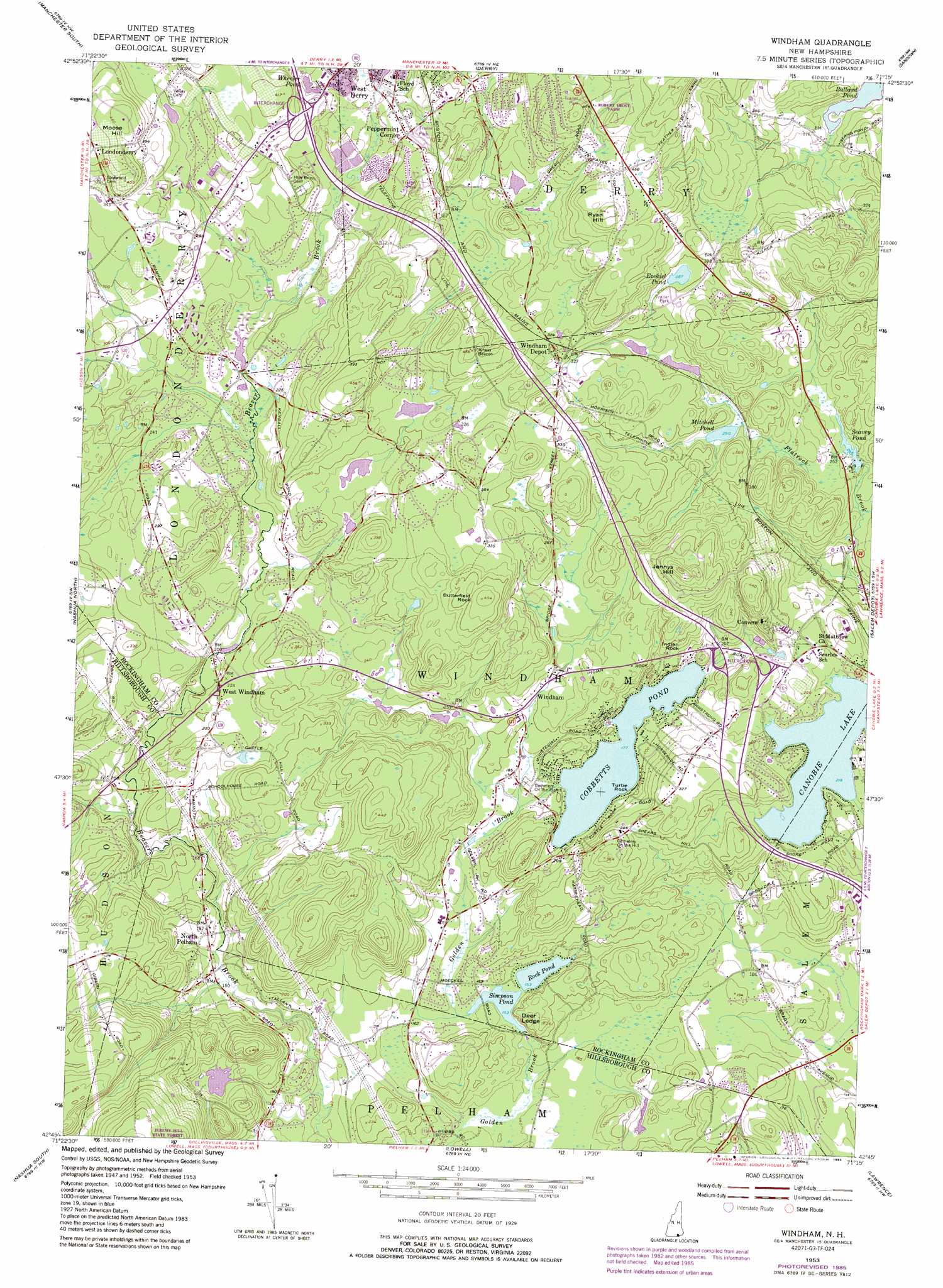
USGS Topo Quad 42071g3 - 1:24,000 scale
| Topo Map Name: | Windham |
| USGS Topo Quad ID: | 42071g3 |
| Print Size: | ca. 21 1/4" wide x 27" high |
| Southeast Coordinates: | 42.75° N latitude / 71.25° W longitude |
| Map Center Coordinates: | 42.8125° N latitude / 71.3125° W longitude |
| U.S. State: | NH |
| Filename: | o42071g3.jpg |
| Download Map JPG Image: | Windham topo map 1:24,000 scale |
| Map Type: | Topographic |
| Topo Series: | 7.5´ |
| Map Scale: | 1:24,000 |
| Source of Map Images: | United States Geological Survey (USGS) |
| Alternate Map Versions: |
Windham NH 1953, updated 1956 Download PDF Buy paper map Windham NH 1953, updated 1967 Download PDF Buy paper map Windham NH 1953, updated 1976 Download PDF Buy paper map Windham NH 1953, updated 1985 Download PDF Buy paper map Windham NH 1953, updated 1985 Download PDF Buy paper map Windham NH 2012 Download PDF Buy paper map Windham NH 2015 Download PDF Buy paper map |
1:24,000 Topo Quads surrounding Windham
Goffstown |
Manchester North |
Candia |
Mount Pawtuckaway |
Epping |
Pinardville |
Manchester South |
Derry |
Sandown |
Kingston |
South Merrimack |
Nashua North |
Windham |
Haverhill |
|
Pepperell |
Lowell |
South Groveland |
||
Ayer |
Billerica |
Reading |
> Back to 42071e1 at 1:100,000 scale
> Back to 42070a1 at 1:250,000 scale
> Back to U.S. Topo Maps home
Windham topo map: Gazetteer
Windham: Capes
Turtle Rock elevation 54m 177′Windham: Crossings
Interchange 3 elevation 61m 200′Interchange 4 elevation 100m 328′
Windham: Dams
Canobie Lake Dam elevation 73m 239′Kendall Pond Dam elevation 67m 219′
Londonderry Treatment Lagoon Dike elevation 73m 239′
Moeckel Pond Dam elevation 44m 144′
Windham: Lakes
Cobbetts Pond elevation 54m 177′Ezekiel Pond elevation 87m 285′
Mitchell Pond elevation 75m 246′
Rock Pond elevation 45m 147′
Wheeler Pond elevation 84m 275′
Windham: Parks
Canobie Lake Park elevation 70m 229′Windham: Pillars
Indian Rock elevation 80m 262′Windham: Populated Places
Londonderry elevation 127m 416′North Pelham elevation 52m 170′
Peppermint Corner elevation 86m 282′
West Derry elevation 86m 282′
West Windham elevation 67m 219′
Windham elevation 60m 196′
Windham Depot elevation 103m 337′
Windham: Post Offices
Londonderry Post Office elevation 97m 318′Windham Post Office elevation 55m 180′
Windham: Reservoirs
Canobie Lake elevation 69m 226′Kendall Pond elevation 67m 219′
Londonderry Sewage Lagoon elevation 73m 239′
Moeckel Pond elevation 44m 144′
Seavey Pond elevation 75m 246′
Simpson Pond elevation 44m 144′
Windham: Summits
Butterfield Rock elevation 135m 442′Deer Ledge elevation 78m 255′
Jennys Hill elevation 154m 505′
Moose Hill elevation 143m 469′
Ryan Hill elevation 153m 501′
Windham: Swamps
Ballard Marsh elevation 77m 252′Windham digital topo map on disk
Buy this Windham topo map showing relief, roads, GPS coordinates and other geographical features, as a high-resolution digital map file on DVD:
Maine, New Hampshire, Rhode Island & Eastern Massachusetts
Buy digital topo maps: Maine, New Hampshire, Rhode Island & Eastern Massachusetts