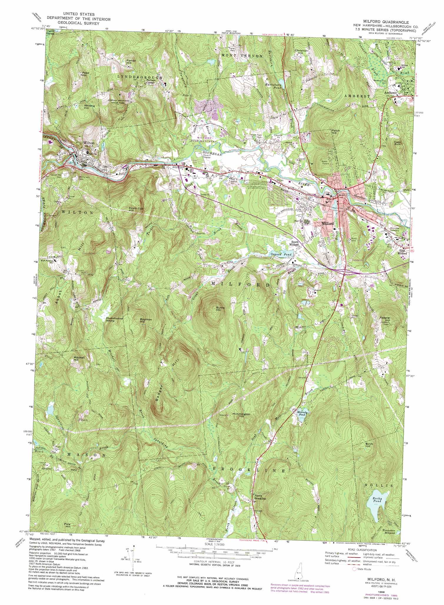
Milford Topo Map New Hampshire
To zoom in, hover over the map of Milford
USGS Topo Quad 42071g6 - 1:24,000 scale
| Topo Map Name: | Milford |
| USGS Topo Quad ID: | 42071g6 |
| Print Size: | ca. 21 1/4" wide x 27" high |
| Southeast Coordinates: | 42.75° N latitude / 71.625° W longitude |
| Map Center Coordinates: | 42.8125° N latitude / 71.6875° W longitude |
| U.S. State: | NH |
| Filename: | o42071g6.jpg |
| Download Map JPG Image: | Milford topo map 1:24,000 scale |
| Map Type: | Topographic |
| Topo Series: | 7.5´ |
| Map Scale: | 1:24,000 |
| Source of Map Images: | United States Geological Survey (USGS) |
| Alternate Map Versions: |
Milford NH 1968, updated 1971 Download PDF Buy paper map Milford NH 1968, updated 1978 Download PDF Buy paper map Milford NH 1968, updated 1985 Download PDF Buy paper map Milford NH 2012 Download PDF Buy paper map Milford NH 2015 Download PDF Buy paper map |
1:24,000 Topo Quads surrounding Milford
Hillsboro |
Deering |
Weare |
Goffstown |
Manchester North |
Peterborough North |
Greenfield |
New Boston |
Pinardville |
Manchester South |
Peterborough South |
Greenville |
Milford |
South Merrimack |
Nashua North |
Ashby |
Pepperell |
|||
Fitchburg |
Ayer |
> Back to 42071e1 at 1:100,000 scale
> Back to 42070a1 at 1:250,000 scale
> Back to U.S. Topo Maps home
Milford topo map: Gazetteer
Milford: Airports
Shanklin Heliport elevation 249m 816′Milford: Crossings
Interchange 2 elevation 87m 285′Milford: Dams
Abbott Memorial Trust Dam elevation 109m 357′Hillsborough Mills Dam elevation 103m 337′
Milford Town Dam elevation 68m 223′
Osgood Pond Dam elevation 81m 265′
Souhegan River Watershed Dam Number 33 elevation 208m 682′
Milford: Lakes
Melendy Pond elevation 126m 413′Rocky Pond elevation 139m 456′
Milford: Parks
Amherst Village Historic District elevation 107m 351′Curtiss Dogwood State Park elevation 231m 757′
Endicott Park elevation 73m 239′
Union Square elevation 77m 252′
Milford: Populated Places
Amherst elevation 79m 259′Curtis Corner elevation 216m 708′
East Milford elevation 76m 249′
Field and Stream Travel Trailer Park elevation 110m 360′
Milford elevation 81m 265′
North Brookline elevation 88m 288′
Perham Corner elevation 179m 587′
Richardson (historical) elevation 79m 259′
South Milford elevation 88m 288′
Wilton elevation 116m 380′
Milford: Post Offices
Wilton Post Office elevation 108m 354′Milford: Reservoirs
Hartshorn Pond elevation 110m 360′Osgood Pond elevation 81m 265′
Souhegan River Reservoir elevation 103m 337′
Souhegan River Reservoir elevation 68m 223′
Milford: Streams
Birch Brook elevation 82m 269′Black Brook elevation 160m 524′
Ceasars Brook elevation 75m 246′
Great Brook elevation 73m 239′
Hartshorn Brook elevation 76m 249′
Medlyn-Woods Brook elevation 64m 209′
Mitchell Brook elevation 112m 367′
Ox Brook elevation 82m 269′
Purgatory Brook elevation 77m 252′
Scab Mill Brook elevation 81m 265′
Spaulding Brook elevation 81m 265′
Stony Brook elevation 104m 341′
Tucker Brook elevation 73m 239′
Milford: Summits
Abbot Hill elevation 280m 918′Badger Hill elevation 236m 774′
Birch Hill elevation 247m 810′
Boynton Hill elevation 247m 810′
Burns Hill elevation 218m 715′
Christian Hill elevation 178m 583′
Dram Cup Hill elevation 242m 793′
Eagle Rock elevation 158m 518′
Federal Hill elevation 210m 688′
Hutchington Hill elevation 174m 570′
Mitchell Hill elevation 267m 875′
Parker Hill elevation 227m 744′
Patch Hill elevation 168m 551′
Pead Hill elevation 279m 915′
Pole Hill elevation 259m 849′
Whiting Hill elevation 248m 813′
Milford: Swamps
Rhododendron Swamp elevation 178m 583′Milford: Trails
Mitchell Hill Road elevation 224m 734′Milford digital topo map on disk
Buy this Milford topo map showing relief, roads, GPS coordinates and other geographical features, as a high-resolution digital map file on DVD:
Maine, New Hampshire, Rhode Island & Eastern Massachusetts
Buy digital topo maps: Maine, New Hampshire, Rhode Island & Eastern Massachusetts