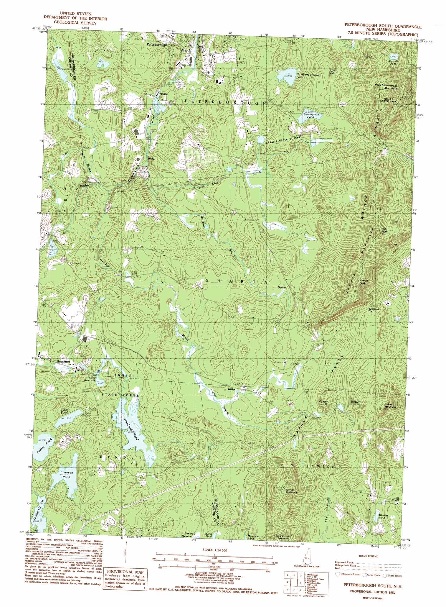
Peterborough South Topo Map New Hampshire
To zoom in, hover over the map of Peterborough South
USGS Topo Quad 42071g8 - 1:24,000 scale
| Topo Map Name: | Peterborough South |
| USGS Topo Quad ID: | 42071g8 |
| Print Size: | ca. 21 1/4" wide x 27" high |
| Southeast Coordinates: | 42.75° N latitude / 71.875° W longitude |
| Map Center Coordinates: | 42.8125° N latitude / 71.9375° W longitude |
| U.S. State: | NH |
| Filename: | o42071g8.jpg |
| Download Map JPG Image: | Peterborough South topo map 1:24,000 scale |
| Map Type: | Topographic |
| Topo Series: | 7.5´ |
| Map Scale: | 1:24,000 |
| Source of Map Images: | United States Geological Survey (USGS) |
| Alternate Map Versions: |
Peterborough South NH 1987, updated 1987 Download PDF Buy paper map Peterborough South NH 1997, updated 1998 Download PDF Buy paper map Peterborough South NH 2012 Download PDF Buy paper map Peterborough South NH 2015 Download PDF Buy paper map |
1:24,000 Topo Quads surrounding Peterborough South
Stoddard |
Hillsboro |
Deering |
Weare |
|
Dublin |
Peterborough North |
Greenfield |
New Boston |
|
Monadnock Mountain |
Peterborough South |
Greenville |
Milford |
|
Winchendon |
Ashby |
|||
Templeton |
Fitchburg |
> Back to 42071e1 at 1:100,000 scale
> Back to 42070a1 at 1:250,000 scale
> Back to U.S. Topo Maps home
Peterborough South topo map: Gazetteer
Peterborough South: Airports
Millipore Heliport elevation 341m 1118′Peterborough South: Dams
Black Reservoir Lower Dam elevation 324m 1062′Black Reservoir Upper Dam elevation 332m 1089′
Crowcroft Pond Dam elevation 354m 1161′
Hubbard Pond Dam elevation 336m 1102′
Jaffrey Wastewater Treatment Plant Dam elevation 286m 938′
Noone Mills Dam elevation 225m 738′
Peterborough South: Gaps
Spofford Gap elevation 425m 1394′Peterborough South: Lakes
Bullet Pond elevation 363m 1190′Cranberry Meadow Pond elevation 308m 1010′
Crowcroft Pond elevation 353m 1158′
Cunningham Pond elevation 368m 1207′
Emerson Pond elevation 356m 1167′
Topside Pond elevation 455m 1492′
Wheeler Pond elevation 376m 1233′
Peterborough South: Parks
Annett State Reservation elevation 341m 1118′Casalis Marsh Wildlife Area elevation 382m 1253′
Fosket Wildlife Refuge elevation 357m 1171′
Miller State Park elevation 592m 1942′
Peterborough South: Populated Places
Drury elevation 242m 793′Hadley elevation 278m 912′
Noone elevation 233m 764′
Peterborough elevation 219m 718′
Sharon elevation 356m 1167′
Squantum elevation 323m 1059′
Wilder elevation 360m 1181′
Peterborough South: Reservoirs
Black Reservoir elevation 324m 1062′Black Reservoir elevation 332m 1089′
Contoocook River Reservoir elevation 225m 738′
Crowcroft Pond elevation 354m 1161′
Hubbard Pond elevation 336m 1102′
Jaffrey Wastewater Lagoons elevation 286m 938′
Peterborough South: Streams
Gridley River elevation 250m 820′Meadow Brook elevation 243m 797′
Town Farm Brook elevation 256m 839′
Town Line Brook elevation 246m 807′
Peterborough South: Summits
Barrett Mountain elevation 561m 1840′Burton Peak elevation 605m 1984′
Conant Hill elevation 462m 1515′
Holt Peak elevation 619m 2030′
Kidder Mountain elevation 549m 1801′
Oak Hill elevation 403m 1322′
Pack Monadnock Mountain elevation 695m 2280′
Temple Mountain elevation 597m 1958′
Wildcat Hill elevation 528m 1732′
Peterborough South: Swamps
Tophet Swamp elevation 350m 1148′Peterborough South: Trails
Wapack Trail elevation 550m 1804′Peterborough South digital topo map on disk
Buy this Peterborough South topo map showing relief, roads, GPS coordinates and other geographical features, as a high-resolution digital map file on DVD:
Maine, New Hampshire, Rhode Island & Eastern Massachusetts
Buy digital topo maps: Maine, New Hampshire, Rhode Island & Eastern Massachusetts