Kingston Topo Map New Hampshire
To zoom in, hover over the map of Kingston
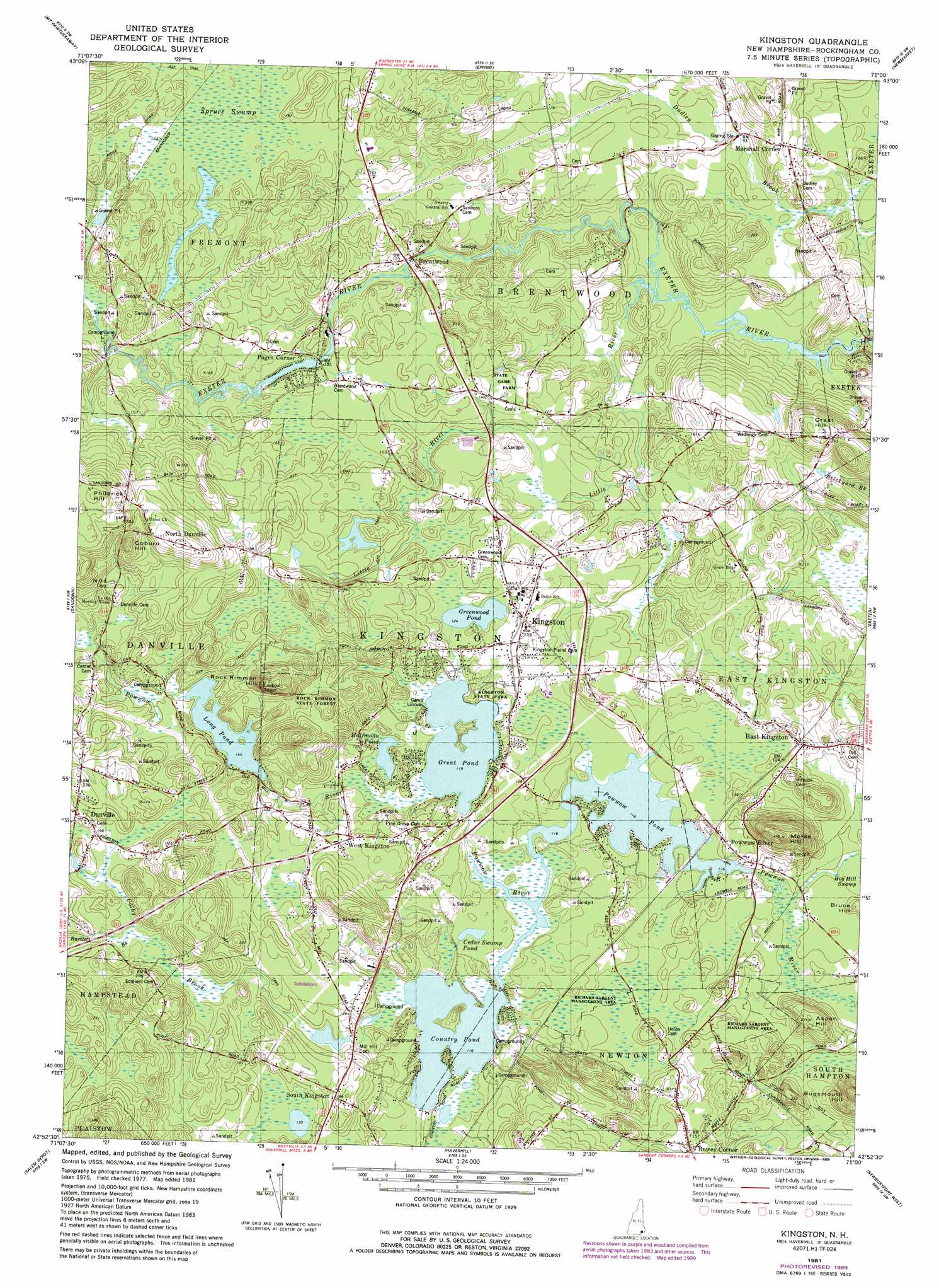
USGS Topo Quad 42071h1 - 1:24,000 scale
| Topo Map Name: | Kingston |
| USGS Topo Quad ID: | 42071h1 |
| Print Size: | ca. 21 1/4" wide x 27" high |
| Southeast Coordinates: | 42.875° N latitude / 71° W longitude |
| Map Center Coordinates: | 42.9375° N latitude / 71.0625° W longitude |
| U.S. State: | NH |
| Filename: | o42071h1.jpg |
| Download Map JPG Image: | Kingston topo map 1:24,000 scale |
| Map Type: | Topographic |
| Topo Series: | 7.5´ |
| Map Scale: | 1:24,000 |
| Source of Map Images: | United States Geological Survey (USGS) |
| Alternate Map Versions: |
Kingston NH 1981, updated 1981 Download PDF Buy paper map Kingston NH 1981, updated 1989 Download PDF Buy paper map Kingston NH 2012 Download PDF Buy paper map Kingston NH 2015 Download PDF Buy paper map |
1:24,000 Topo Quads surrounding Kingston
Gossville |
Northwood |
Barrington |
Dover West |
Dover East |
Candia |
Mount Pawtuckaway |
Epping |
Newmarket |
Portsmouth |
Derry |
Sandown |
Kingston |
Hampton |
|
Windham |
Haverhill |
Newburyport East |
||
Lowell |
South Groveland |
Ipswich |
> Back to 42071e1 at 1:100,000 scale
> Back to 42070a1 at 1:250,000 scale
> Back to U.S. Topo Maps home
Kingston topo map: Gazetteer
Kingston: Airports
Pow-Wow Seaplane Base elevation 35m 114′Winterwood Airport elevation 38m 124′
Kingston: Dams
Dustin Pond Dam elevation 42m 137′Long Pond Dam elevation 45m 147′
Pickpocket Dam elevation 19m 62′
Trickling Falls Dam elevation 35m 114′
Kingston: Forests
Rock Rimmon State Forest elevation 76m 249′Kingston: Lakes
Country Pond elevation 35m 114′Great Pond elevation 36m 118′
Greenwood Pond elevation 38m 124′
Halfmoon Pond elevation 35m 114′
Long Pond elevation 44m 144′
Powwow Pond elevation 35m 114′
Kingston: Parks
Kingston State Park elevation 38m 124′Richard Sargent Management Area elevation 38m 124′
Richard Sargent Management Area elevation 34m 111′
Webster Natural Area elevation 36m 118′
Kingston: Populated Places
Brentwood elevation 35m 114′Danville elevation 62m 203′
East Kingston elevation 43m 141′
Fremont Station elevation 42m 137′
Kingston elevation 40m 131′
Marshall Corner elevation 39m 127′
North Danville elevation 78m 255′
Pages Corner elevation 41m 134′
Powwow River elevation 39m 127′
Rowes Corner elevation 46m 150′
South Kingston elevation 56m 183′
West Kingston elevation 46m 150′
Kingston: Reservoirs
Exeter River Reservoir elevation 42m 137′Exeter River Reservoir elevation 19m 62′
Powwow Pond elevation 35m 114′
Kingston: Streams
Bartlett Brook elevation 53m 173′Colby Brook elevation 43m 141′
Little River elevation 20m 65′
Kingston: Summits
Aspen Hill elevation 64m 209′Coburn Hill elevation 96m 314′
Great Hill elevation 81m 265′
Morse Hill elevation 94m 308′
Philbrick Hill elevation 101m 331′
Rock Rimmon Hill elevation 100m 328′
Kingston: Swamps
Cedar Swamp Pond elevation 35m 114′Spruce Swamp elevation 50m 164′
Kingston digital topo map on disk
Buy this Kingston topo map showing relief, roads, GPS coordinates and other geographical features, as a high-resolution digital map file on DVD:
Maine, New Hampshire, Rhode Island & Eastern Massachusetts
Buy digital topo maps: Maine, New Hampshire, Rhode Island & Eastern Massachusetts