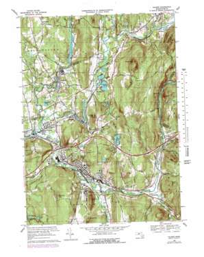
Palmer Topo Map Massachusetts
To zoom in, hover over the map of Palmer
USGS Topo Quad 42072b3 - 1:25,000 scale
| Topo Map Name: | Palmer |
| USGS Topo Quad ID: | 42072b3 |
| Print Size: | ca. 21 1/4" wide x 27" high |
| Southeast Coordinates: | 42.125° N latitude / 72.25° W longitude |
| Map Center Coordinates: | 42.1875° N latitude / 72.3125° W longitude |
| U.S. State: | MA |
| Filename: | l42072b3.jpg |
| Download Map JPG Image: | Palmer topo map 1:25,000 scale |
| Map Type: | Topographic |
| Topo Series: | 7.5´ |
| Map Scale: | 1:25,000 |
| Source of Map Images: | United States Geological Survey (USGS) |
| Alternate Map Versions: |
Palmer MA 1947 Download PDF Buy paper map Palmer MA 1969, updated 1979 Download PDF Buy paper map Palmer MA 1969, updated 1979 Download PDF Buy paper map Palmer MA 1975, updated 1981 Download PDF Buy paper map |
1:24,000 Topo Quads surrounding Palmer
> Back to 42072a1 at 1:100,000 scale
> Back to 42072a1 at 1:250,000 scale
> Back to U.S. Topo Maps home
Palmer topo map: Gazetteer
Palmer: Airports
Metropolitan Airport elevation 126m 413′Palmer: Bridges
Fays Bridge elevation 97m 318′Palmer: Dams
Baldwin Pond Dam elevation 135m 442′Bondsville Lower Dam elevation 106m 347′
Forest Lake Dam elevation 112m 367′
Palmer Reservoir Upper Dam elevation 159m 521′
Textile Printing Company Upper Dam elevation 124m 406′
Thompson Lake Dam elevation 171m 561′
Ware River Dam elevation 102m 334′
Ware River Dam elevation 107m 351′
Palmer: Lakes
Crystal Lake elevation 94m 308′Knox Pond elevation 125m 410′
Lilly Pond elevation 107m 351′
Pattaquattic Pond elevation 110m 360′
Palmer: Parks
Pulaski Park elevation 108m 354′Palmer: Populated Places
Bardwell elevation 112m 367′Blanchardville elevation 108m 354′
Bondsville elevation 108m 354′
Cold Spring elevation 170m 557′
Duckville elevation 111m 364′
Fentonville elevation 112m 367′
Four Corners elevation 108m 354′
Gibbs Crossing elevation 122m 400′
Meadowbrook Green elevation 144m 472′
Palmer elevation 105m 344′
Palmer Center elevation 147m 482′
Palmer Green Estates elevation 110m 360′
Tenneyville elevation 106m 347′
Thorndike elevation 137m 449′
Three Rivers elevation 99m 324′
West Brimfield elevation 121m 396′
Whipples elevation 117m 383′
Palmer: Post Offices
Bondsville Post Office elevation 106m 347′Palmer Post Office (historical) elevation 134m 439′
Thorndike Post Office elevation 113m 370′
Three Rivers Post Office elevation 92m 301′
Palmer: Reservoirs
Baldwin Pond elevation 128m 419′Forest Lake elevation 133m 436′
Freitag Pond elevation 134m 439′
Palmer Reservoir elevation 159m 521′
Swift River Reservoir elevation 124m 406′
Swift River Reservoir elevation 106m 347′
Thompson Lake elevation 171m 561′
Ware River Reservoir elevation 107m 351′
Ware River Reservoir elevation 102m 334′
Palmer: Streams
Beaver Brook elevation 123m 403′Blodgett Mill Brook elevation 115m 377′
Bottle Brook elevation 109m 357′
Chicopee Brook elevation 191m 626′
Dumplin Brook elevation 89m 291′
Flat Brook elevation 118m 387′
Foskett Mill Stream elevation 108m 354′
Jabish Brook elevation 89m 291′
Kings Brook elevation 111m 364′
Penny Brook elevation 114m 374′
Penny Brook elevation 111m 364′
Quaboag River elevation 89m 291′
Swift River elevation 89m 291′
Turkey Brook elevation 186m 610′
Ware River elevation 89m 291′
Palmer: Summits
Bald Peak elevation 295m 967′Baptist Hill elevation 153m 501′
Bunyan Mountain elevation 232m 761′
Chicopee Mountain elevation 211m 692′
Cooks Mountain elevation 286m 938′
Devils Peak elevation 250m 820′
Fenton Mountain elevation 259m 849′
Fox Hill elevation 302m 990′
Kings Mountain elevation 212m 695′
Mount Dumplin elevation 205m 672′
Pattaquattic Hill elevation 317m 1040′
Palmer digital topo map on disk
Buy this Palmer topo map showing relief, roads, GPS coordinates and other geographical features, as a high-resolution digital map file on DVD:
New York, Vermont, Connecticut & Western Massachusetts
Buy digital topo maps: New York, Vermont, Connecticut & Western Massachusetts


