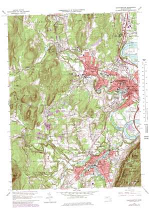
Easthampton Topo Map Massachusetts
To zoom in, hover over the map of Easthampton
USGS Topo Quad 42072c6 - 1:25,000 scale
| Topo Map Name: | Easthampton |
| USGS Topo Quad ID: | 42072c6 |
| Print Size: | ca. 21 1/4" wide x 27" high |
| Southeast Coordinates: | 42.25° N latitude / 72.625° W longitude |
| Map Center Coordinates: | 42.3125° N latitude / 72.6875° W longitude |
| U.S. State: | MA |
| Filename: | l42072c6.jpg |
| Download Map JPG Image: | Easthampton topo map 1:25,000 scale |
| Map Type: | Topographic |
| Topo Series: | 7.5´ |
| Map Scale: | 1:25,000 |
| Source of Map Images: | United States Geological Survey (USGS) |
| Alternate Map Versions: |
Easthampton MA 1964, updated 1979 Download PDF Buy paper map Easthampton MA 1964, updated 1979 Download PDF Buy paper map |
1:24,000 Topo Quads surrounding Easthampton
Ashfield |
Greenfield |
|||
Goshen |
Mount Toby |
|||
Westhampton |
Easthampton |
Mount Holyoke |
Belchertown |
|
Woronoco |
Mount Tom |
Springfield North |
Ludlow |
|
Southwick |
West Springfield |
Springfield South |
Hampden |
> Back to 42072a1 at 1:100,000 scale
> Back to 42072a1 at 1:250,000 scale
> Back to U.S. Topo Maps home
Easthampton topo map: Gazetteer
Easthampton: Canals
Mill River Diversion elevation 27m 88′Easthampton: Crossings
Interchange Eighteen elevation 42m 137′Interchange Twenty elevation 54m 177′
Interchange Twenty One elevation 47m 154′
Easthampton: Dams
Lower Millpond Dam elevation 42m 137′Manhan River Dam elevation 49m 160′
Mill River Dam elevation 69m 226′
Mill River Dam elevation 35m 114′
Nashawannuck Pond Dam elevation 46m 150′
Paradise Pond Dam elevation 42m 137′
Rocky Hill Pond Dam elevation 66m 216′
Vistron Dam elevation 73m 239′
Easthampton: Flats
Hockanum Meadows elevation 27m 88′Manhan Meadows elevation 33m 108′
Pynchon Meadows elevation 33m 108′
Roberts Meadow elevation 126m 413′
Easthampton: Islands
Canary Island elevation 33m 108′Easthampton: Lakes
Danks Pond elevation 30m 98′Florence Pond elevation 80m 262′
Hulberts Pond elevation 27m 88′
The Oxbow elevation 27m 88′
Easthampton: Parks
Arcadia Sanctuary elevation 39m 127′Childs Park elevation 67m 219′
Childs Park elevation 69m 226′
Fort Hill Historic District elevation 49m 160′
Japanese Garden and Tea Hut elevation 52m 170′
Kearney Field elevation 48m 157′
Look Memorial Park elevation 80m 262′
Main Street Historic District elevation 58m 190′
Maines Field elevation 67m 219′
Mount Tom State Reservation elevation 191m 626′
Nonotuck Park elevation 54m 177′
Northampton Downtown Historic District elevation 48m 157′
Easthampton: Populated Places
Bay State elevation 65m 213′Easthampton elevation 49m 160′
Florence elevation 84m 275′
Laurel Park elevation 62m 203′
Leeds elevation 117m 383′
Loudville elevation 103m 337′
North Farms elevation 106m 347′
Northampton elevation 76m 249′
Pine Grove elevation 82m 269′
West Farms elevation 91m 298′
West Hatfield elevation 46m 150′
West Whately elevation 51m 167′
Easthampton: Post Offices
Easthampton Post Office elevation 55m 180′Florence Post Office elevation 84m 275′
Haydenville Post Office elevation 126m 413′
Leeds Post Office elevation 107m 351′
Northampton Post Office elevation 39m 127′
Easthampton: Reservoirs
Brass Millpond elevation 123m 403′Clear Falls Pond elevation 107m 351′
Lower Millpond elevation 42m 137′
Manhan River Reservoir elevation 49m 160′
Mill River Diversion Reservoir elevation 35m 114′
Mill River Reservoir elevation 42m 137′
Mill River Reservoir elevation 69m 226′
Mill River Reservoir elevation 73m 239′
Mount Tom Reservoir elevation 123m 403′
Mountain Park Reservoir elevation 217m 711′
Nashawannuck Pond elevation 46m 150′
Paradise Pond elevation 40m 131′
Roberts Meadow Reservoir elevation 119m 390′
Rocky Hill Pond elevation 66m 216′
Rubber Thread Pond elevation 47m 154′
Upper Reservoir elevation 134m 439′
Easthampton: Streams
Bassett Brook elevation 39m 127′Beaver Brook elevation 109m 357′
Brickyard Brook elevation 39m 127′
Broad Brook elevation 34m 111′
Clark Brook elevation 122m 400′
Day Brook elevation 105m 344′
Hannum Brook elevation 39m 127′
Marble Brook elevation 143m 469′
North Branch Manhan River elevation 42m 137′
Parsons Brook elevation 69m 226′
Plum Brook elevation 44m 144′
Roberts Meadow Brook elevation 104m 341′
Running Gutter elevation 39m 127′
Turkey Brook elevation 116m 380′
White Brook elevation 46m 150′
Wilton Brook elevation 48m 157′
Easthampton: Summits
Baker Hill elevation 98m 321′Bald Hill elevation 207m 679′
Deadtop elevation 333m 1092′
Dry Knoll elevation 250m 820′
Goat Peak elevation 252m 826′
Miller Hill elevation 185m 606′
Mineral Hills elevation 248m 813′
Pomeroy Mountain elevation 352m 1154′
Roberts Hill elevation 177m 580′
Round Hill elevation 81m 265′
Sawmill Hills elevation 187m 613′
Turkey Hill elevation 230m 754′
Whiting Peak elevation 305m 1000′
Easthampton: Swamps
Neds Ditch elevation 33m 108′Pomeroys Meadow elevation 61m 200′
Easthampton digital topo map on disk
Buy this Easthampton topo map showing relief, roads, GPS coordinates and other geographical features, as a high-resolution digital map file on DVD:
New York, Vermont, Connecticut & Western Massachusetts
Buy digital topo maps: New York, Vermont, Connecticut & Western Massachusetts


