Quabbin Reservoir Topo Map Massachusetts
To zoom in, hover over the map of Quabbin Reservoir
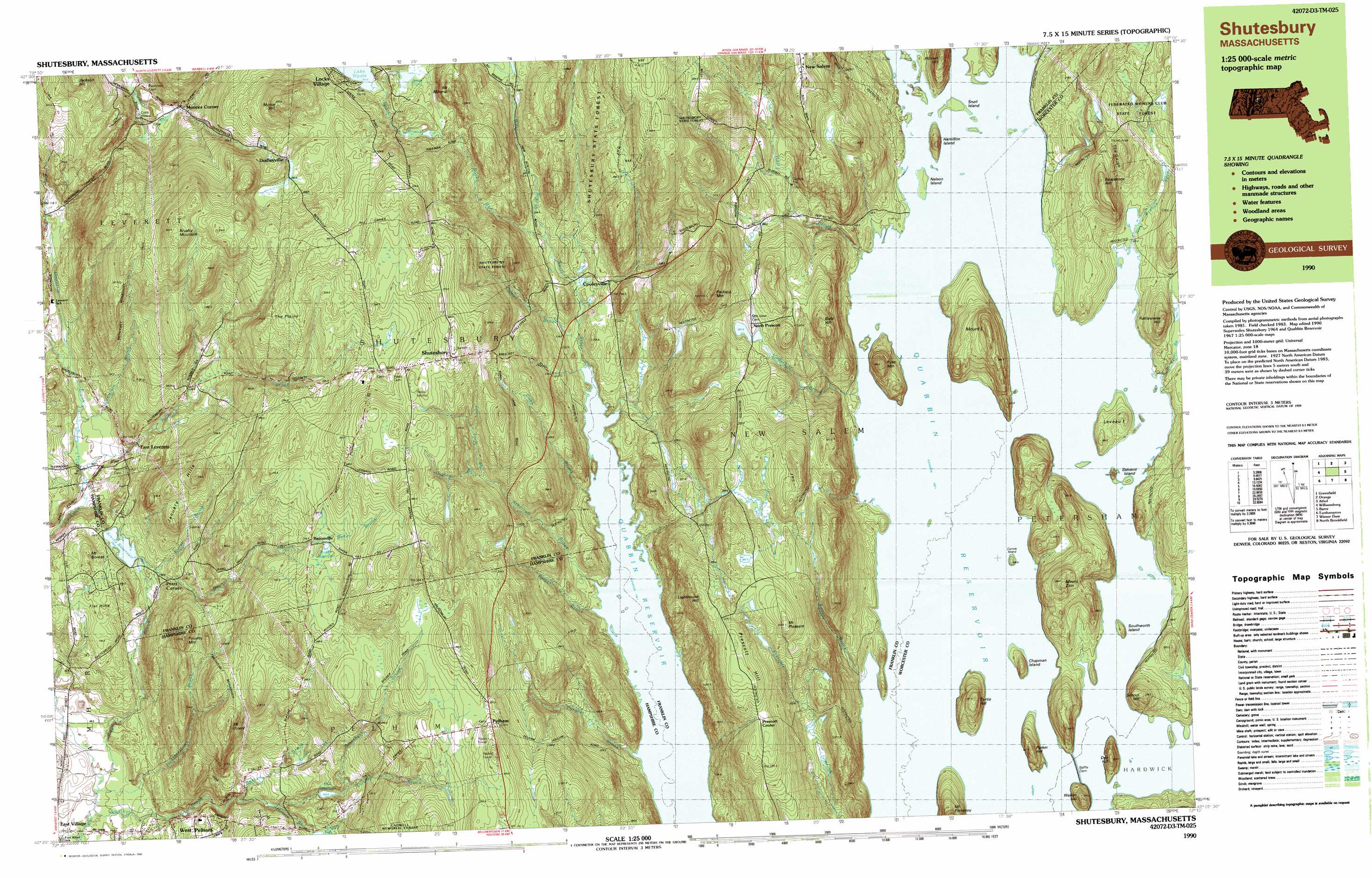
USGS Topo Quad 42072d3 - 1:25,000 scale
| Topo Map Name: | Quabbin Reservoir |
| USGS Topo Quad ID: | 42072d3 |
| Print Size: | ca. 39" wide x 24" high |
| Southeast Coordinates: | 42.375° N latitude / 72.25° W longitude |
| Map Center Coordinates: | 42.4375° N latitude / 72.375° W longitude |
| U.S. State: | MA |
| Filename: | k42072d3.jpg |
| Download Map JPG Image: | Quabbin Reservoir topo map 1:25,000 scale |
| Map Type: | Topographic |
| Topo Series: | 7.5´x15´ |
| Map Scale: | 1:25,000 |
| Source of Map Images: | United States Geological Survey (USGS) |
| Alternate Map Versions: |
Shutesbury MA 1990, updated 1990 Download PDF Buy paper map Shutesbury MA 1990, updated 1990 Download PDF Buy paper map |
1:24,000 Topo Quads surrounding Quabbin Reservoir
Bernardston |
Mount Grace |
Winchendon |
||
Greenfield |
Orange |
Templeton |
||
Mount Toby |
Quabbin Reservoir |
Barre |
||
Mount Holyoke |
Belchertown |
Winsor Dam |
North Brookfield |
|
Springfield North |
Ludlow |
Palmer |
East Brookfield |
> Back to 42072a1 at 1:100,000 scale
> Back to 42072a1 at 1:250,000 scale
> Back to U.S. Topo Maps home
Quabbin Reservoir topo map: Gazetteer
Quabbin Reservoir: Capes
Prescott Peninsula elevation 351m 1151′Quabbin Reservoir: Dams
Ames Pond Upper Dam elevation 273m 895′Baffle Dam elevation 160m 524′
Dudleyville Pond Dam elevation 293m 961′
Intake Reservoir Dam elevation 145m 475′
Quabbin Reservoir: Flats
The Plains elevation 332m 1089′Quabbin Reservoir: Forests
Shutesbury State Forest elevation 304m 997′Quabbin Reservoir: Islands
Carrick Island elevation 164m 538′Chapman Island elevation 173m 567′
Hamilton Island elevation 191m 626′
Leveau Island elevation 178m 583′
Mount L elevation 284m 931′
Nelson Island elevation 162m 531′
Russ Mountain elevation 257m 843′
Snell Island elevation 162m 531′
Southworth Island elevation 168m 551′
Stevens Island elevation 179m 587′
Quabbin Reservoir: Lakes
Ash Pond elevation 160m 524′Curtis Pond elevation 160m 524′
Dead Pond elevation 160m 524′
Dudleys Pond elevation 292m 958′
Gibbs Pond elevation 160m 524′
Hackmetack Pond elevation 160m 524′
Leonards Pond elevation 337m 1105′
Nance Lake elevation 160m 524′
Neeseponsett Pond elevation 160m 524′
Russ Pond elevation 160m 524′
Sunk Pond elevation 160m 524′
Thompson Pond elevation 160m 524′
Turtle Pond elevation 160m 524′
Quabbin Reservoir: Parks
Amethyst Conservation Area elevation 60m 196′Pelham Town Hall Historic District elevation 346m 1135′
Quabbin Reservoir: Populated Places
Baconville elevation 294m 964′Cooleyville elevation 210m 688′
Dana (historical) elevation 160m 524′
Dudleyville elevation 282m 925′
East Leverett elevation 136m 446′
East Village elevation 55m 180′
Greenwich Village (historical) elevation 160m 524′
Millington (historical) elevation 160m 524′
Moores Corner elevation 192m 629′
North Dana (historical) elevation 160m 524′
North Prescott elevation 259m 849′
Pelham elevation 345m 1131′
Pratt Corner elevation 147m 482′
Prescott (historical) elevation 304m 997′
Prescott Center elevation 305m 1000′
Shutesbury elevation 375m 1230′
West Pelham elevation 110m 360′
Quabbin Reservoir: Reservoirs
Ames Pond elevation 273m 895′Atkins Reservoir elevation 135m 442′
Baker Reservoir elevation 298m 977′
Hawley Reservoir elevation 184m 603′
Hill Reservoir elevation 181m 593′
Quabbin Reservoir: Ridges
Prescott Ridge elevation 306m 1003′Quabbin Reservoir: Springs
Orient Springs elevation 126m 413′Quabbin Reservoir: Streams
Adams Brook elevation 53m 173′Amethyst Brook elevation 53m 173′
Atherton Brook elevation 160m 524′
Baker Brook elevation 294m 964′
Briggs Brook elevation 160m 524′
Buffam Brook elevation 123m 403′
Camel Brook elevation 165m 541′
Cobb Brook elevation 160m 524′
Dean Brook elevation 125m 410′
Doolittle Brook elevation 100m 328′
Dunlop Brook elevation 196m 643′
East Branch Fever Brook elevation 162m 531′
Egypt Brook elevation 160m 524′
Fever Brook elevation 160m 524′
Gates Brook elevation 171m 561′
Harris Brook elevation 146m 479′
Hearthstone Brook elevation 60m 196′
Hop Brook elevation 161m 528′
Keyup Brook elevation 316m 1036′
Mountain Brook elevation 104m 341′
Nurse Brook elevation 136m 446′
Osgood Brook elevation 266m 872′
Purgee Brook elevation 160m 524′
Roaring Brook elevation 105m 344′
Rocky Run elevation 186m 610′
South Brook elevation 254m 833′
Town Farm Brook elevation 266m 872′
Underhill Brook elevation 160m 524′
West Branch Fever Brook elevation 160m 524′
Quabbin Reservoir: Summits
Bials Hill elevation 320m 1049′Brushy Mountain elevation 380m 1246′
Butter Hill elevation 204m 669′
Curtis Hill elevation 231m 757′
Den Hill elevation 228m 748′
Flat Hills elevation 151m 495′
Jackson Hill elevation 279m 915′
January Hills elevation 256m 839′
Lighthouse Hill elevation 322m 1056′
Morse Hill elevation 366m 1200′
Mount Boreas elevation 179m 587′
Mount Mineral elevation 276m 905′
Mount Orient elevation 291m 954′
Mount Pleasant elevation 335m 1099′
Mount Pomeroy elevation 261m 856′
Mount Zion elevation 260m 853′
Packard Mountain elevation 386m 1266′
Parker Hill elevation 200m 656′
Pine Hill elevation 371m 1217′
Pitman Hill elevation 233m 764′
Poverty Mountain elevation 247m 810′
Prescott Hill elevation 336m 1102′
Rattlesnake Hill elevation 250m 820′
School Hill elevation 236m 774′
Soapstone Hill elevation 269m 882′
Walker Hill elevation 205m 672′
Quabbin Reservoir: Valleys
Rattlesnake Gutter elevation 123m 403′The Gorge elevation 190m 623′
The Gorge elevation 169m 554′
Quabbin Reservoir digital topo map on disk
Buy this Quabbin Reservoir topo map showing relief, roads, GPS coordinates and other geographical features, as a high-resolution digital map file on DVD:
New York, Vermont, Connecticut & Western Massachusetts
Buy digital topo maps: New York, Vermont, Connecticut & Western Massachusetts