Greenfield Topo Map Massachusetts
To zoom in, hover over the map of Greenfield
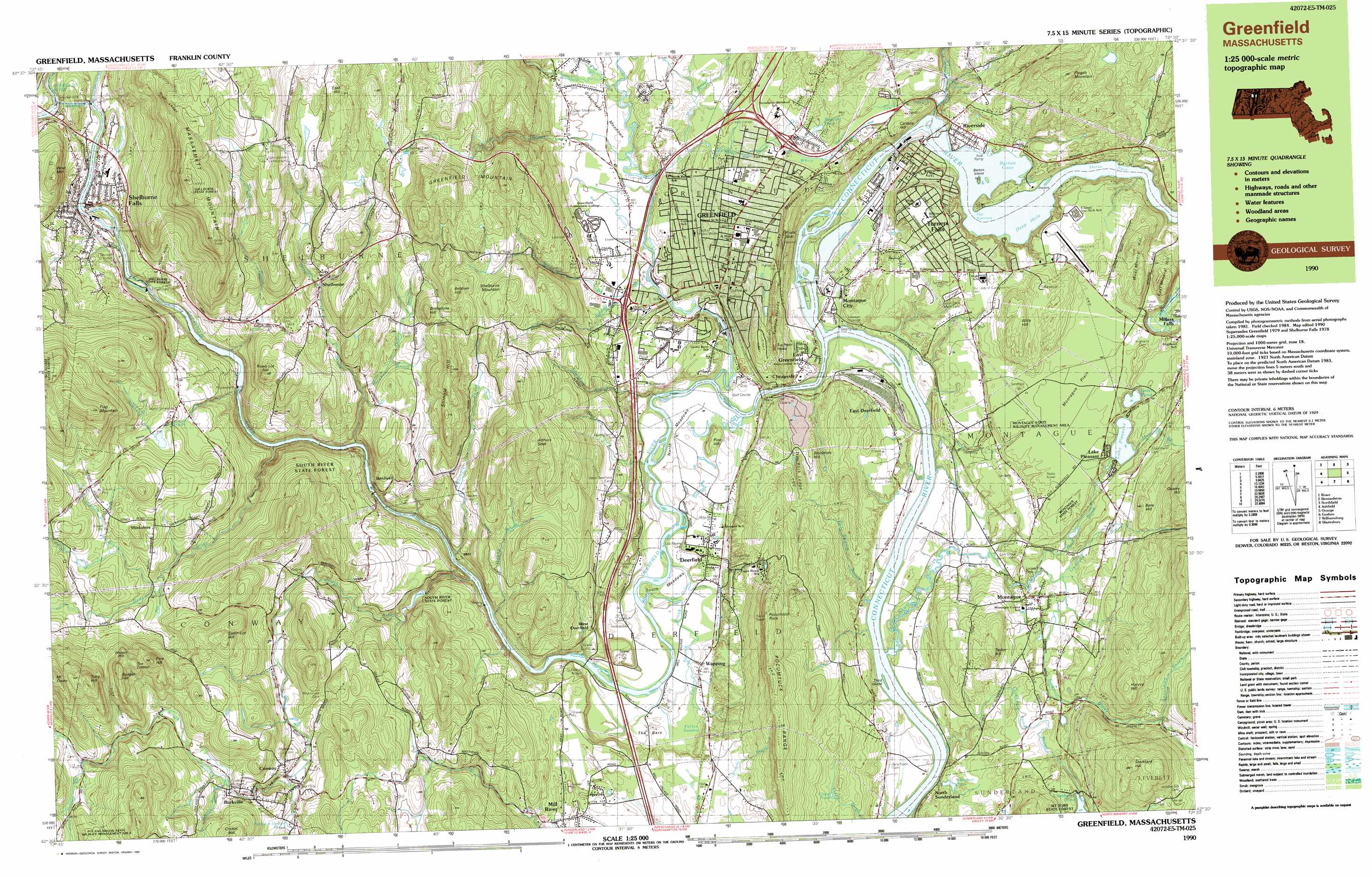
USGS Topo Quad 42072e5 - 1:25,000 scale
| Topo Map Name: | Greenfield |
| USGS Topo Quad ID: | 42072e5 |
| Print Size: | ca. 39" wide x 24" high |
| Southeast Coordinates: | 42.5° N latitude / 72.5° W longitude |
| Map Center Coordinates: | 42.5625° N latitude / 72.625° W longitude |
| U.S. State: | MA |
| Filename: | k42072e5.jpg |
| Download Map JPG Image: | Greenfield topo map 1:25,000 scale |
| Map Type: | Topographic |
| Topo Series: | 7.5´x15´ |
| Map Scale: | 1:25,000 |
| Source of Map Images: | United States Geological Survey (USGS) |
| Alternate Map Versions: |
Greenfield MA 1990, updated 1990 Download PDF Buy paper map Greenfield MA 1990, updated 1990 Download PDF Buy paper map Greenfield MA 1990, updated 1990 Download PDF Buy paper map |
1:24,000 Topo Quads surrounding Greenfield
Jacksonville |
Brattleboro |
West Swanzey |
||
Heath |
Bernardston |
Mount Grace |
||
Ashfield |
Greenfield |
Orange |
||
Goshen |
Mount Toby |
Quabbin Reservoir |
||
Westhampton |
Easthampton |
Mount Holyoke |
Belchertown |
Winsor Dam |
> Back to 42072e1 at 1:100,000 scale
> Back to 42072a1 at 1:250,000 scale
> Back to U.S. Topo Maps home
Greenfield topo map: Gazetteer
Greenfield: Airports
Turners Falls Airport elevation 107m 351′Greenfield: Bays
Barton Cove elevation 54m 177′Lily Pond elevation 54m 177′
Greenfield: Beaches
Greenfield Beach elevation 47m 154′Horse Race elevation 54m 177′
Greenfield: Bridges
Burkeville Covered Bridge elevation 197m 646′Pumping Station Covered Bridge elevation 57m 187′
Stillwater Bridge elevation 50m 164′
Greenfield: Canals
Power Canal elevation 52m 170′Greenfield: Capes
Doctors Island elevation 54m 177′Greenfield: Crossings
Interchange Twenty Seven elevation 90m 295′Interchange Twenty Six elevation 59m 193′
Greenfield: Dams
Albert Davenport Dam elevation 140m 459′Bowens Pond Dam elevation 103m 337′
Cabot Station Power Plant Dam elevation 44m 144′
Conway Electric Dam elevation 112m 367′
Cranberry Pond Dam elevation 110m 360′
Gardner Falls Main Dam elevation 97m 318′
Gardner Falls Station Canal Dam elevation 105m 344′
Greenfield Electric Light and Power Dam elevation 42m 137′
New England Power Company Dam Number 2 elevation 89m 291′
New England Power Company Dam Number 3 Forebay elevation 99m 324′
New England Power Company Number 3 Dam elevation 113m 370′
New England Power Company Number 4 Forebay Dam elevation 127m 416′
New England Power Number 4 Dam elevation 146m 479′
Turners Falls Canal Headgates elevation 54m 177′
Turners Falls Dam elevation 54m 177′
Turners Falls Number 1 Dam elevation 48m 157′
Whitmore Pond Dam elevation 64m 209′
Greenfield: Falls
The Cascades elevation 78m 255′Turners Falls elevation 36m 118′
Greenfield: Flats
Deerfield Meadows elevation 37m 121′Montague Plain elevation 106m 347′
North Meadows elevation 42m 137′
South Meadows elevation 46m 150′
The Bars elevation 54m 177′
Wilder Flat elevation 212m 695′
Greenfield: Forests
Mount Toby State Forest elevation 128m 419′Shelburne State Forest elevation 96m 314′
South River State Forest elevation 74m 242′
Greenfield: Gaps
The Narrows elevation 54m 177′Greenfield: Islands
Barton Island elevation 59m 193′Middle Ground elevation 204m 669′
Peskeomskut Island elevation 42m 137′
Poets Seat elevation 144m 472′
Rawson Island elevation 38m 124′
Smead Island elevation 36m 118′
Third Island elevation 30m 98′
Greenfield: Lakes
Clapp Pond elevation 100m 328′Deep Hole elevation 54m 177′
Green Pond elevation 82m 269′
Greenfield: Parks
Highland Park elevation 89m 291′Lake Minola Park elevation 92m 301′
Main Street Historic District elevation 74m 242′
Montague Wildlife Management Area elevation 198m 649′
Old Deerfield Village Historic District elevation 45m 147′
Rocky Mountain Park elevation 110m 360′
Shelburne Falls Historic District elevation 125m 410′
Temple Woods elevation 115m 377′
Turner Falls Historic District elevation 75m 246′
Greenfield: Populated Places
Bardwell elevation 65m 213′Burkville elevation 213m 698′
Cheapside elevation 79m 259′
Conway elevation 172m 564′
Deerfield elevation 53m 173′
East Deerfield elevation 61m 200′
East Greenfield elevation 51m 167′
Factory Village (historical) elevation 67m 219′
Greenfield elevation 73m 239′
Lake Pleasant elevation 97m 318′
Mill River elevation 103m 337′
Montague elevation 69m 226′
Montague City elevation 48m 157′
Montague Station elevation 73m 239′
North Sunderland elevation 39m 127′
Riverside elevation 60m 196′
Shelburne elevation 177m 580′
Shelburne Falls elevation 123m 403′
Shirkshire elevation 242m 793′
The Patten elevation 427m 1400′
Turners Falls elevation 74m 242′
Wapping elevation 49m 160′
West Deerfield elevation 93m 305′
Greenfield: Post Offices
Conway Post Office elevation 175m 574′Montague Post Office elevation 73m 239′
Shelburne Falls Post Office elevation 131m 429′
Greenfield: Reservoirs
Albert Davenport Pond elevation 140m 459′Bowens Pond elevation 103m 337′
Connecticut River Reservoir elevation 54m 177′
Connecticut River Reservoir elevation 54m 177′
Conway Electric Reservoir elevation 112m 367′
Cranberry Pond elevation 110m 360′
Deerfield River Reservoir elevation 89m 291′
Deerfield River Reservoir elevation 146m 479′
Deerfield River Reservoir elevation 113m 370′
Deerfield River Reservoir elevation 97m 318′
Gardner Falls Station Canal Reservoir elevation 105m 344′
Lake Pleasant elevation 82m 269′
Maynard Pond elevation 89m 291′
Montague Power Canal Reservoir elevation 44m 144′
Nash Pond elevation 66m 216′
Number 3 Forebay Reservoir elevation 99m 324′
Power Canal Reservoir elevation 48m 157′
Turners Falls Reservoir elevation 140m 459′
Whitmore Pond elevation 66m 216′
Greenfield: Ridges
High Ledge elevation 389m 1276′Pocumtuck Range elevation 166m 544′
Rocky Mountain elevation 114m 374′
Greenfield: Streams
Allen Brook elevation 53m 173′Arms Brook elevation 45m 147′
Bear River elevation 73m 239′
Chadwick Brook elevation 104m 341′
Cherry Rum Brook elevation 66m 216′
Cranberry Pond Brook elevation 30m 98′
Deerfield River elevation 98m 321′
Dragon Brook elevation 70m 229′
Drakes Brook elevation 191m 626′
Fall Brook elevation 43m 141′
Fall River elevation 36m 118′
Fall River elevation 36m 118′
Fuller Swamp Brook elevation 42m 137′
Goddard Brook elevation 63m 206′
Graves Brook elevation 83m 272′
Great Brook elevation 151m 495′
Green River elevation 34m 111′
Green River elevation 34m 111′
Gunn Brook elevation 33m 108′
Hannegan Brook elevation 83m 272′
Hawkes Brook elevation 113m 370′
Hawks Brook elevation 70m 229′
Hinsdale Brook elevation 60m 196′
Johnny Bean Brook elevation 199m 652′
Mill Brook elevation 78m 255′
Mill Brook Stream elevation 42m 137′
Pea Brook elevation 214m 702′
Poland Brook elevation 246m 807′
Pole Swamp Brook elevation 30m 98′
Pond Brook elevation 59m 193′
Pumpkin Hollow Brook elevation 170m 557′
Punch Brook elevation 54m 177′
Sawmill River elevation 30m 98′
Schneck Brook elevation 79m 259′
Sheldon Brook elevation 31m 101′
Shingle Brook elevation 56m 183′
Sids Brook elevation 222m 728′
Sluice Brook elevation 89m 291′
Smead Brook elevation 47m 154′
South River elevation 73m 239′
Spaulding Brook elevation 118m 387′
The Oxbow elevation 42m 137′
Wheeler Brook elevation 54m 177′
Greenfield: Summits
Arthurs Seat elevation 293m 961′Badger Hill elevation 370m 1213′
Bald Mountain elevation 485m 1591′
Bare Hill elevation 139m 456′
Bellows Hill elevation 292m 958′
Brimstone Hill elevation 250m 820′
Canada Hill elevation 103m 337′
Catlin Lot Hill elevation 325m 1066′
Cricket Hill elevation 301m 987′
Dragon Hill elevation 250m 820′
East Hill elevation 349m 1145′
East Mineral Hill elevation 153m 501′
Flag Mountain elevation 427m 1400′
Great Hill elevation 301m 987′
Greenfield Mountain elevation 295m 967′
Harvey Hill elevation 235m 770′
Massaemett Mountain elevation 417m 1368′
Pine Hill elevation 61m 200′
Pine Hill elevation 357m 1171′
Pisgah Mountain elevation 250m 820′
Pocumtuck Rock elevation 255m 836′
Sachem Head elevation 133m 436′
Shelburne Mountain elevation 272m 892′
Shingle Hill elevation 271m 889′
Stoddard Hill elevation 252m 826′
Taylor Hill elevation 168m 551′
The Colonel elevation 333m 1092′
Toby Hill elevation 410m 1345′
Trap Rock Ledge elevation 134m 439′
Walters Hill elevation 379m 1243′
West Mineral Hill elevation 143m 469′
West Mountain elevation 245m 803′
Wills Hill elevation 169m 554′
Woolman Hill elevation 122m 400′
Greenfield: Swamps
Fuller Swamp elevation 45m 147′White Ash Swamp elevation 84m 275′
Greenfield: Valleys
Toby Hollow elevation 297m 974′Wilcox Hollow elevation 102m 334′
Greenfield digital topo map on disk
Buy this Greenfield topo map showing relief, roads, GPS coordinates and other geographical features, as a high-resolution digital map file on DVD:
New York, Vermont, Connecticut & Western Massachusetts
Buy digital topo maps: New York, Vermont, Connecticut & Western Massachusetts