Winchendon Topo Map Massachusetts
To zoom in, hover over the map of Winchendon
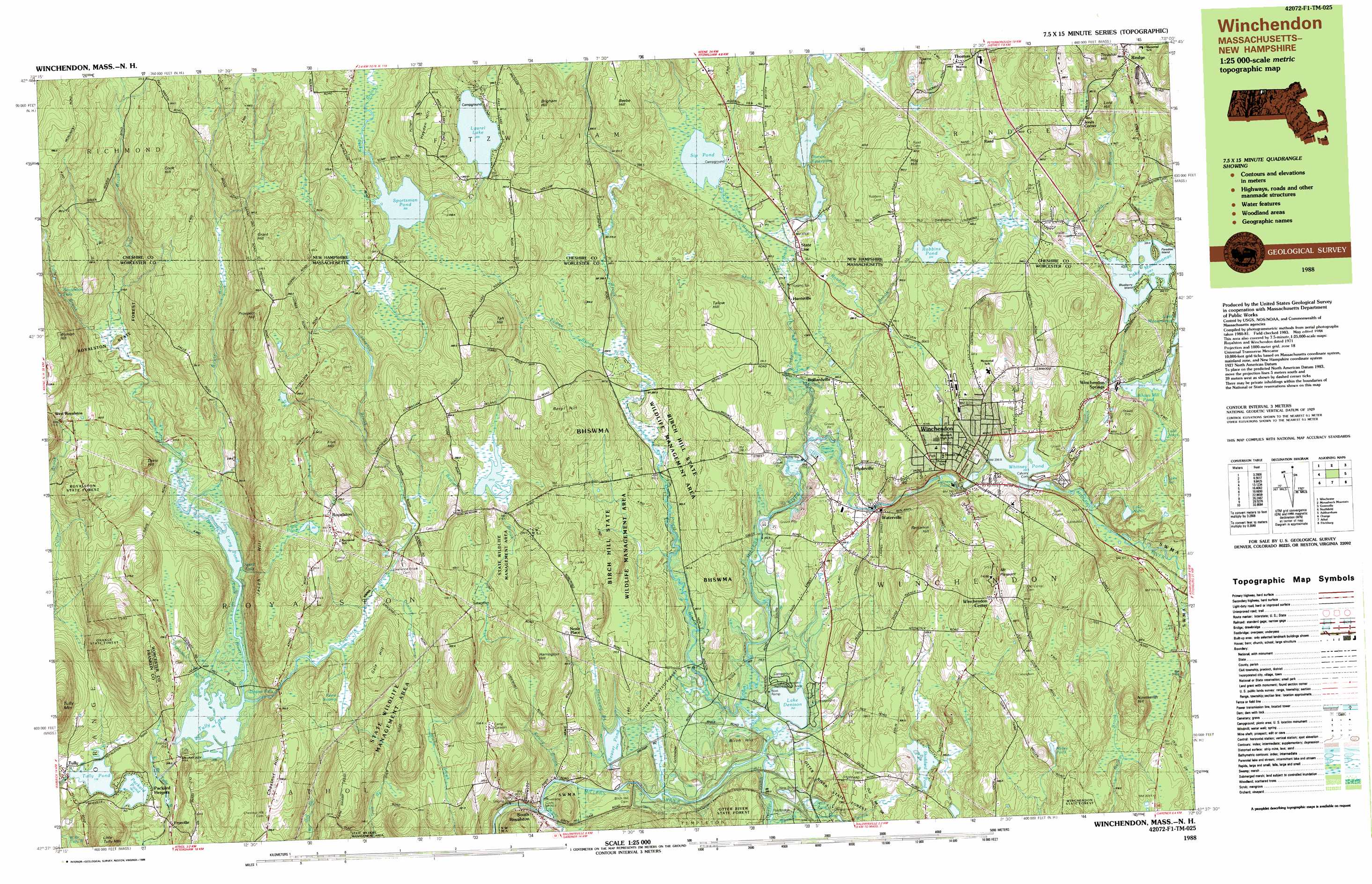
USGS Topo Quad 42072f1 - 1:25,000 scale
| Topo Map Name: | Winchendon |
| USGS Topo Quad ID: | 42072f1 |
| Print Size: | ca. 39" wide x 24" high |
| Southeast Coordinates: | 42.625° N latitude / 72° W longitude |
| Map Center Coordinates: | 42.6875° N latitude / 72.125° W longitude |
| U.S. States: | MA, NH |
| Filename: | k42072f1.jpg |
| Download Map JPG Image: | Winchendon topo map 1:25,000 scale |
| Map Type: | Topographic |
| Topo Series: | 7.5´x15´ |
| Map Scale: | 1:25,000 |
| Source of Map Images: | United States Geological Survey (USGS) |
| Alternate Map Versions: |
Winchendon MA 1988, updated 1988 Download PDF Buy paper map Winchendon MA 1988, updated 1988 Download PDF Buy paper map |
1:24,000 Topo Quads surrounding Winchendon
Keene |
Dublin |
Peterborough North |
Greenfield |
|
West Swanzey |
Monadnock Mountain |
Peterborough South |
Greenville |
|
Mount Grace |
Winchendon |
Ashby |
||
Orange |
Templeton |
Fitchburg |
||
Quabbin Reservoir |
Barre |
Sterling |
> Back to 42072e1 at 1:100,000 scale
> Back to 42072a1 at 1:250,000 scale
> Back to U.S. Topo Maps home
Winchendon topo map: Gazetteer
Winchendon: Cliffs
Jacob Hill elevation 315m 1033′Winchendon: Dams
Birch Hill Dam elevation 259m 849′Birch Hill Dam elevation 250m 820′
Damon Mill Pond Dam elevation 284m 931′
Damon Upper Reservoir Dam elevation 281m 921′
Flis Pond Dam elevation 302m 990′
Hunts Pond Dam elevation 297m 974′
Lake Monomonac Dam elevation 317m 1040′
Lake Monomonac Dam elevation 319m 1046′
Packard Pond Dam elevation 187m 613′
Putney Mill Dam elevation 297m 974′
Robbins Pond Dam elevation 316m 1036′
Sportsman Pond Dam elevation 305m 1000′
Stoddard Pond Dam elevation 289m 948′
Tannery Pond Dam elevation 288m 944′
Tully Dam elevation 200m 656′
Tully Pond Dam elevation 176m 577′
Tully River Dam elevation 190m 623′
Whites Mill Pond Dam elevation 308m 1010′
Whitney Pond Dam elevation 295m 967′
Winchendon: Falls
Doane Falls elevation 233m 764′Royalston Falls elevation 261m 856′
Spirit Falls elevation 238m 780′
Winchendon: Forests
Grant State Forest elevation 341m 1118′Orange State Forest elevation 264m 866′
Royalston State Forest elevation 234m 767′
Royalston State Forest elevation 216m 708′
Winchendon: Islands
Blueberry Island elevation 321m 1053′Blueberry Island elevation 321m 1053′
Paradise Island elevation 332m 1089′
Winchendon: Lakes
Beaman Pond elevation 264m 866′Bedman Pond elevation 255m 836′
Lake Denison elevation 250m 820′
Lake Jones elevation 323m 1059′
Lake Martin elevation 311m 1020′
Lake Sal elevation 324m 1062′
Laurel Lake elevation 335m 1099′
Little Pond elevation 301m 987′
Long Pond elevation 195m 639′
Mellen Pond elevation 328m 1076′
Mud Pond elevation 255m 836′
Robbins Pond elevation 314m 1030′
Sip Pond elevation 271m 889′
Winchendon: Parks
Bamans Pond Recreation Area elevation 261m 856′Birch Hill State Wildlife Management Area elevation 267m 875′
Hyde Park elevation 310m 1017′
Lawrence Brook Wildlife Management Area elevation 285m 935′
Millers River Wildlife Management Area elevation 274m 898′
Old Centre Historic District elevation 374m 1227′
Royalston Common Historic District elevation 307m 1007′
V F W Park elevation 368m 1207′
Winchendon: Populated Places
Bullardville elevation 261m 856′Camp Caravan elevation 339m 1112′
Fryeville elevation 185m 606′
Glenallen elevation 313m 1026′
Harrisville elevation 269m 882′
Hydeville elevation 272m 892′
Jones Corner elevation 383m 1256′
Neale Place elevation 325m 1066′
Packard Heights elevation 184m 603′
Parkers Station elevation 259m 849′
Pequoig elevation 307m 1007′
Rand elevation 351m 1151′
Royalston elevation 308m 1010′
South Royalston elevation 262m 859′
State Line elevation 270m 885′
Thomas elevation 351m 1151′
Tully elevation 177m 580′
Waterville elevation 275m 902′
West Royalston elevation 273m 895′
Winchendon elevation 304m 997′
Winchendon Center elevation 376m 1233′
Winchendon Springs elevation 307m 1007′
Winchendon: Post Offices
Winchendon Post Office elevation 298m 977′Winchendon: Reservoirs
Beaver Pond elevation 255m 836′Damon Mill Pond elevation 284m 931′
Damon Reservoirs elevation 275m 902′
Damon Upper Reservoir elevation 281m 921′
Flis Pond elevation 302m 990′
Hunts Pond elevation 297m 974′
Lake Monomonac elevation 319m 1046′
Millers River Reservoir elevation 288m 944′
Packard Pond elevation 187m 613′
Robbins Pond elevation 316m 1036′
Sportsman Pond elevation 305m 1000′
Stoddard Pond elevation 289m 948′
Tannery Pond elevation 288m 944′
Tully Lake elevation 200m 656′
Tully Pond elevation 176m 577′
Whites Mill Pond elevation 308m 1010′
Whitney Pond elevation 298m 977′
Winchendon: Streams
Beaman Brook elevation 249m 816′Beaver Brook elevation 248m 813′
Beaver Brook elevation 255m 836′
Boyce Brook elevation 201m 659′
Boyce Brook elevation 201m 659′
Dunham Brook elevation 254m 833′
Falls Brook elevation 206m 675′
Falls Brook elevation 206m 675′
Kemp Brook elevation 307m 1007′
Kenny Brook elevation 247m 810′
Lawrence Brook elevation 195m 639′
Lawrence Brook elevation 195m 639′
Lord Brook elevation 318m 1043′
North Branch Millers River elevation 295m 967′
North Branch Millers River elevation 296m 971′
Otter River elevation 253m 830′
Priest Brook elevation 250m 820′
Robbins Brook elevation 264m 866′
Robbins Brook elevation 255m 836′
Scott Brook elevation 264m 866′
Shepardson Brook elevation 196m 643′
Sip Pond Brook elevation 268m 879′
Spud Brook elevation 268m 879′
Stockwell Brook elevation 249m 816′
Tarbell Brook elevation 262m 859′
Tarbell Brook elevation 252m 826′
Towne Brook elevation 265m 869′
Tully Brook elevation 207m 679′
Tully Brook elevation 206m 675′
Winchendon: Summits
Beebe Hill elevation 343m 1125′Benjamin Hill elevation 377m 1236′
Beryl Hill elevation 334m 1095′
Birch Hill elevation 275m 902′
Brigham Hill elevation 405m 1328′
Chestnut Hill elevation 308m 1010′
Cook Hill elevation 367m 1204′
Davis Hill elevation 299m 980′
Frye Hill elevation 370m 1213′
Gale Hill elevation 319m 1046′
Grant Hill elevation 380m 1246′
Harrington Hill elevation 369m 1210′
Hayden Hill elevation 378m 1240′
Hog Hill elevation 369m 1210′
Little Tully Mountain elevation 261m 856′
Lord Hill elevation 378m 1240′
Mount Pleasant elevation 393m 1289′
Nineteenth Hill elevation 372m 1220′
Prospect Hill elevation 407m 1335′
Taft Hill elevation 376m 1233′
Tallow Hill elevation 333m 1092′
Thrasher Hill elevation 417m 1368′
Towne Hill elevation 353m 1158′
Wyman Hill elevation 355m 1164′
Winchendon: Swamps
Paine Swamp elevation 253m 830′Winchendon digital topo map on disk
Buy this Winchendon topo map showing relief, roads, GPS coordinates and other geographical features, as a high-resolution digital map file on DVD:
New York, Vermont, Connecticut & Western Massachusetts
Buy digital topo maps: New York, Vermont, Connecticut & Western Massachusetts