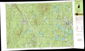
Monadnock Mountain Topo Map New Hampshire
To zoom in, hover over the map of Monadnock Mountain
USGS Topo Quad 42072g1 - 1:25,000 scale
| Topo Map Name: | Monadnock Mountain |
| USGS Topo Quad ID: | 42072g1 |
| Print Size: | ca. 39" wide x 24" high |
| Southeast Coordinates: | 42.75° N latitude / 72° W longitude |
| Map Center Coordinates: | 42.8125° N latitude / 72.125° W longitude |
| U.S. State: | NH |
| Filename: | k42072g1.jpg |
| Download Map JPG Image: | Monadnock Mountain topo map 1:25,000 scale |
| Map Type: | Topographic |
| Topo Series: | 7.5´x15´ |
| Map Scale: | 1:25,000 |
| Source of Map Images: | United States Geological Survey (USGS) |
| Alternate Map Versions: |
Monadnock Mountain NH 1984, updated 1984 Download PDF Buy paper map Monadnock Mountain NH 1984, updated 1984 Download PDF Buy paper map |
1:24,000 Topo Quads surrounding Monadnock Mountain
Gilsum |
Stoddard |
Hillsboro |
Deering |
|
Keene |
Dublin |
Peterborough North |
Greenfield |
|
West Swanzey |
Monadnock Mountain |
Peterborough South |
Greenville |
|
Mount Grace |
Winchendon |
Ashby |
||
Orange |
Templeton |
Fitchburg |
> Back to 42072e1 at 1:100,000 scale
> Back to 42072a1 at 1:250,000 scale
> Back to U.S. Topo Maps home
Monadnock Mountain topo map: Gazetteer
Monadnock Mountain: Airports
Jaffrey Municipal-Silver Ranch Airport elevation 311m 1020′Monadnock Mountain: Dams
Bowkerville Dam elevation 357m 1171′Cheshire Pond Dam elevation 297m 974′
Contoocook Lake Dam elevation 307m 1007′
Cummings Meadow Dam elevation 371m 1217′
Gilson Pond Dam elevation 365m 1197′
Horseshoe Pond Dam elevation 311m 1020′
Larrys Pond Dam elevation 346m 1135′
Mountain Brook Dam elevation 309m 1013′
Pearly Lake Dam elevation 307m 1007′
Rockwood Pond Dam elevation 347m 1138′
Scott Pond Dam elevation 329m 1079′
Stone Pond Dam elevation 315m 1033′
Thorndike Pond Dam elevation 358m 1174′
Monadnock Mountain: Flats
Cummings Meadow elevation 368m 1207′Monadnock Mountain: Forests
Gay State Forest elevation 438m 1437′Monadnock Mountain: Lakes
Bowker Pond elevation 354m 1161′Corey Pond elevation 346m 1135′
Farrar Pond elevation 280m 918′
Frost Pond elevation 333m 1092′
Garfield Pond elevation 364m 1194′
Gilmore Pond elevation 321m 1053′
Grassy Pond elevation 360m 1181′
Hodge Pond elevation 327m 1072′
New Cumings Pond elevation 364m 1194′
Parker Pond elevation 314m 1030′
Perkins Pond elevation 374m 1227′
Pool Pond elevation 307m 1007′
Potters Pond elevation 404m 1325′
Rugg Pond elevation 350m 1148′
Whites Pond elevation 348m 1141′
Monadnock Mountain: Parks
Barden State Wildlife Management Area elevation 274m 898′Haven State Park elevation 377m 1236′
Jaffrey Center Historic District elevation 348m 1141′
Monadnock State Park elevation 372m 1220′
Rhododendron State Park elevation 363m 1190′
Richmond Wildlife Manangement Area elevation 250m 820′
Sawyer Tract elevation 493m 1617′
Monadnock Mountain: Populated Places
Bowkerville elevation 355m 1164′Fitzwilliam elevation 349m 1145′
Fitzwilliam Depot elevation 322m 1056′
Jaffrey elevation 304m 997′
Jaffrey Center elevation 347m 1138′
Rindge elevation 397m 1302′
Rockwood elevation 339m 1112′
Troy elevation 309m 1013′
Webb elevation 250m 820′
West Rindge elevation 328m 1076′
Woodmere elevation 324m 1062′
Monadnock Mountain: Post Offices
Jaffrey Post Office elevation 314m 1030′Monadnock Mountain: Reservoirs
Bowker Pond elevation 357m 1171′Cheshire Pond elevation 297m 974′
Contoocook Lake elevation 307m 1007′
Cummings Meadow Reservoir elevation 371m 1217′
Gilson Pond elevation 365m 1197′
Horseshoe Pond elevation 311m 1020′
Larrys Pond elevation 346m 1135′
Mountain Brook Reservoir elevation 309m 1013′
Pearly Lake elevation 307m 1007′
Poole Reservoir elevation 421m 1381′
Rockwood Pond elevation 347m 1138′
Scott Pond elevation 326m 1069′
Stone Pond elevation 315m 1033′
Thorndike Pond elevation 358m 1174′
West Hill Reservoir elevation 371m 1217′
Monadnock Mountain: Streams
Brandy Brook elevation 280m 918′Fassett Brook elevation 342m 1122′
Forbush Brook elevation 176m 577′
Frost Brook elevation 327m 1072′
Gleason Brook elevation 352m 1154′
Mead Brook elevation 317m 1040′
Mills Brook elevation 336m 1102′
Mountain Brook elevation 309m 1013′
Nester Brook elevation 306m 1003′
Quarry Brook elevation 290m 951′
Shaker Brook elevation 277m 908′
Stony Brook elevation 316m 1036′
Tyler Brook elevation 296m 971′
Monadnock Mountain: Summits
Bigelow Hill elevation 472m 1548′Brennan Hill elevation 433m 1420′
Brigham Hill elevation 364m 1194′
Carter Hill elevation 341m 1118′
Cubleigh Hill elevation 419m 1374′
Fern Hill elevation 410m 1345′
Fullam Hill elevation 378m 1240′
Gap Mountain elevation 545m 1788′
Grassy Hill elevation 446m 1463′
Jock Page Hill elevation 392m 1286′
Little Monadnock Mountain elevation 571m 1873′
Monadnock Mountain elevation 941m 3087′
Peabody Hill elevation 346m 1135′
The Pinnacle elevation 467m 1532′
Todd Hill elevation 433m 1420′
Webb Hill elevation 415m 1361′
Whitcomb Hill elevation 342m 1122′
Woodbury Hill elevation 407m 1335′
Monadnock Mountain: Swamps
Dead Swamp elevation 309m 1013′Taggart Meadows elevation 314m 1030′
Monadnock Mountain: Trails
Cascade Link Trail elevation 760m 2493′Farmers Trail elevation 679m 2227′
Harling Trail elevation 430m 1410′
Marlboro Trail elevation 529m 1735′
Parker Trail elevation 381m 1250′
Red Cross Trail elevation 754m 2473′
White Arrow Trail elevation 708m 2322′
White Dot Trail elevation 701m 2299′
Monadnock Mountain digital topo map on disk
Buy this Monadnock Mountain topo map showing relief, roads, GPS coordinates and other geographical features, as a high-resolution digital map file on DVD:
New York, Vermont, Connecticut & Western Massachusetts
Buy digital topo maps: New York, Vermont, Connecticut & Western Massachusetts


