Dublin Topo Map New Hampshire
To zoom in, hover over the map of Dublin
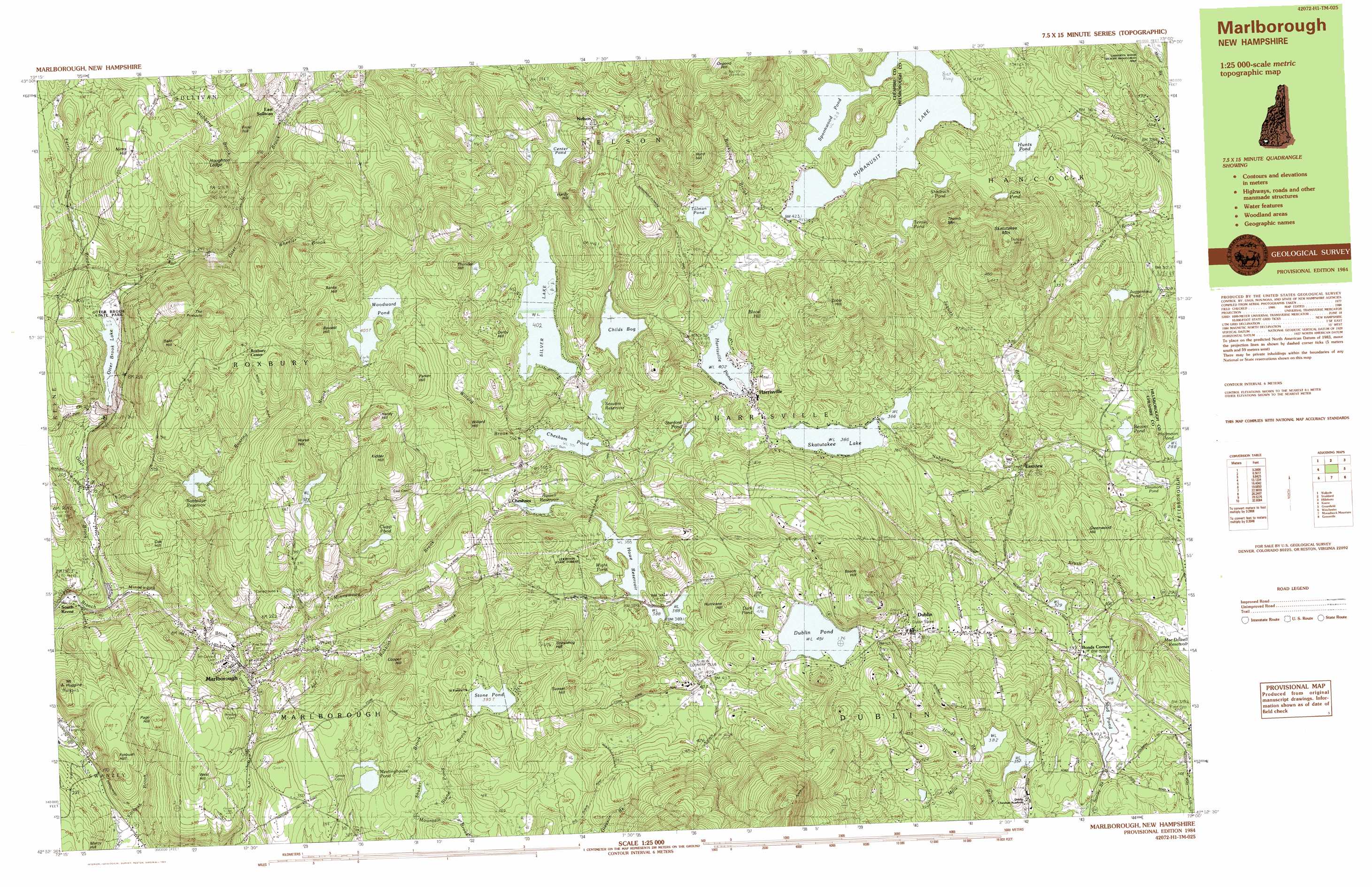
USGS Topo Quad 42072h1 - 1:25,000 scale
| Topo Map Name: | Dublin |
| USGS Topo Quad ID: | 42072h1 |
| Print Size: | ca. 39" wide x 24" high |
| Southeast Coordinates: | 42.875° N latitude / 72° W longitude |
| Map Center Coordinates: | 42.9375° N latitude / 72.125° W longitude |
| U.S. State: | NH |
| Filename: | k42072h1.jpg |
| Download Map JPG Image: | Dublin topo map 1:25,000 scale |
| Map Type: | Topographic |
| Topo Series: | 7.5´x15´ |
| Map Scale: | 1:25,000 |
| Source of Map Images: | United States Geological Survey (USGS) |
| Alternate Map Versions: |
Marlborough NH 1984, updated 1984 Download PDF Buy paper map Marlborough NH 1984, updated 1984 Download PDF Buy paper map |
1:24,000 Topo Quads surrounding Dublin
Alstead |
Washington |
Hillsboro Upper Village |
Henniker |
|
Gilsum |
Stoddard |
Hillsboro |
Deering |
|
Keene |
Dublin |
Peterborough North |
Greenfield |
|
West Swanzey |
Monadnock Mountain |
Peterborough South |
Greenville |
|
Mount Grace |
Winchendon |
Ashby |
> Back to 42072e1 at 1:100,000 scale
> Back to 42072a1 at 1:250,000 scale
> Back to U.S. Topo Maps home
Dublin topo map: Gazetteer
Dublin: Bays
Sucker Brook Cove elevation 402m 1318′Dublin: Dams
Babbidge Reservoir Dam elevation 312m 1023′Center Pond Dam elevation 446m 1463′
Chesham Pond Dam elevation 356m 1167′
Childs Bog Dam elevation 422m 1384′
Dublin Pond Dam elevation 467m 1532′
Echo Lake Dam elevation 400m 1312′
Filtrine Dam elevation 376m 1233′
Half Moon Pond Dam elevation 288m 944′
Harrisville Pond Dam elevation 405m 1328′
Howe Reservoir Dam elevation 390m 1279′
Hunts Pond Dam elevation 396m 1299′
Lake Skatutakee Dam elevation 378m 1240′
Meetinghouse Pond Dam elevation 349m 1145′
Minnewawa Dam elevation 307m 1007′
Mud Pond Dam elevation 315m 1033′
Nubanusit Lake Dam elevation 312m 1023′
Otter Brook Dam elevation 235m 770′
Russell Reservoir Dam elevation 360m 1181′
Seaver Reservoir Dam elevation 393m 1289′
Silver Lake Dam elevation 411m 1348′
Spoonwood Pond Dam elevation 436m 1430′
Stone Pond Dam elevation 387m 1269′
Dublin: Forests
Leighton State Forest elevation 423m 1387′Dublin: Lakes
Beaver Pond elevation 290m 951′Clapp Pond elevation 379m 1243′
Dark Pond elevation 426m 1397′
Dinsmore Pond elevation 286m 938′
Dublin Pond elevation 451m 1479′
Jacks Pond elevation 468m 1535′
Juggernaut Pond elevation 350m 1148′
Mud Pond elevation 318m 1043′
Shadrach Pond elevation 444m 1456′
Silver Lake elevation 402m 1318′
Skatutakee Lake elevation 366m 1200′
Spectacle Pond elevation 378m 1240′
Stanford Pond elevation 396m 1299′
Tenney Pond elevation 485m 1591′
Tolman Pond elevation 440m 1443′
Wight Pond elevation 389m 1276′
Dublin: Parks
Carpenter Marsh State Wildlife Management Area elevation 325m 1066′Chesham Village District elevation 352m 1154′
Dublin Lake Historic District elevation 456m 1496′
Dublin Village Historic District elevation 435m 1427′
Harrisville Historic District elevation 398m 1305′
Harrisville Rural District elevation 327m 1072′
Otter Brook State Park elevation 226m 741′
Peterson State Wildlife Management Area elevation 318m 1043′
Pottersville Historic District elevation 354m 1161′
Ryan State Wildlife Management Area elevation 401m 1315′
Silver Lake District elevation 405m 1328′
Dublin: Pillars
The Pinnacle elevation 360m 1181′Dublin: Populated Places
Bonds Corner elevation 330m 1082′Chesham elevation 368m 1207′
Dublin elevation 454m 1489′
East Sullivan elevation 310m 1017′
Eastview elevation 315m 1033′
Harrisville elevation 407m 1335′
Marlborough elevation 215m 705′
Nelson elevation 438m 1437′
Roxbury Center elevation 415m 1361′
South Keene elevation 161m 528′
Dublin: Post Offices
Marlboro Post Office elevation 211m 692′Dublin: Reservoirs
Babbidge Reservoir elevation 312m 1023′Center Pond elevation 446m 1463′
Chesham Pond elevation 356m 1167′
Childs Bog elevation 422m 1384′
Half Moon Pond elevation 288m 944′
Harrisville Pond elevation 405m 1328′
Howe Reservoir elevation 390m 1279′
Hunts Pond elevation 396m 1299′
Lake Skatutakee elevation 378m 1240′
Meetinghouse Pond elevation 332m 1089′
Minniwawa Brook Reservoir elevation 307m 1007′
Mud Pond elevation 322m 1056′
Nubanusit Brook Reservoir elevation 376m 1233′
Nubanusit Lake elevation 312m 1023′
Otter Brook Lake elevation 227m 744′
Russell Reservoir elevation 360m 1181′
Seaver Reservoir elevation 393m 1289′
Spoonwood Pond elevation 436m 1430′
Stone Pond elevation 387m 1269′
Woodward Pond elevation 400m 1312′
Dublin: Streams
Brickyard Brook elevation 412m 1351′Ferry Brook elevation 215m 705′
Hinds Brook elevation 358m 1174′
Hubbard Brook elevation 272m 892′
Jaquith Brook elevation 293m 961′
Minnewawa Brook elevation 173m 567′
Mountain Brook elevation 342m 1122′
Otter Brook elevation 174m 570′
Roaring Brook elevation 188m 616′
Robbins Brook elevation 230m 754′
Stanley Brook elevation 284m 931′
Stone Pond Brook elevation 347m 1138′
Wheeler Brook elevation 263m 862′
Willard Brook elevation 366m 1200′
Dublin: Summits
Bald Hill elevation 437m 1433′Banks Hill elevation 423m 1387′
Bassett Hill elevation 472m 1548′
Beech Hill elevation 529m 1735′
Blood Hill elevation 465m 1525′
Cobb Hill elevation 555m 1820′
Cooper Hill elevation 399m 1309′
Derby Hill elevation 460m 1509′
Forbush Hill elevation 283m 928′
Frost Hill elevation 400m 1312′
Greenwood Hill elevation 346m 1135′
Hardy Hill elevation 458m 1502′
Hardy Hill elevation 487m 1597′
Horse Hill elevation 455m 1492′
Houghton Ledge elevation 393m 1289′
Hurd Hill elevation 555m 1820′
Hurricane Hill elevation 446m 1463′
Kidder Hill elevation 457m 1499′
Marcy Hill elevation 281m 921′
Mount Huggins elevation 269m 882′
Nims Hill elevation 399m 1309′
Oak Hill elevation 313m 1026′
Osgood Hill elevation 648m 2125′
Page Hill elevation 300m 984′
Parker Hill elevation 481m 1578′
Skatutakee Mountain elevation 585m 1919′
Spaulding Hill elevation 484m 1587′
Sunset Hill elevation 482m 1581′
Thumb Mountain elevation 594m 1948′
Thunder Hill elevation 477m 1564′
West Hill elevation 368m 1207′
Willard Hill elevation 429m 1407′
Dublin: Trails
Pumpelly Trail elevation 730m 2395′Dublin digital topo map on disk
Buy this Dublin topo map showing relief, roads, GPS coordinates and other geographical features, as a high-resolution digital map file on DVD:
New York, Vermont, Connecticut & Western Massachusetts
Buy digital topo maps: New York, Vermont, Connecticut & Western Massachusetts